Storm Chances Continue This Weekend In Green Country
Oklahoma Weather Forecast: Bookmark this page and refresh it often for the latest forecast and daily updates.Sunday, May 5th 2024, 10:42 am


TULSA, Okla. -
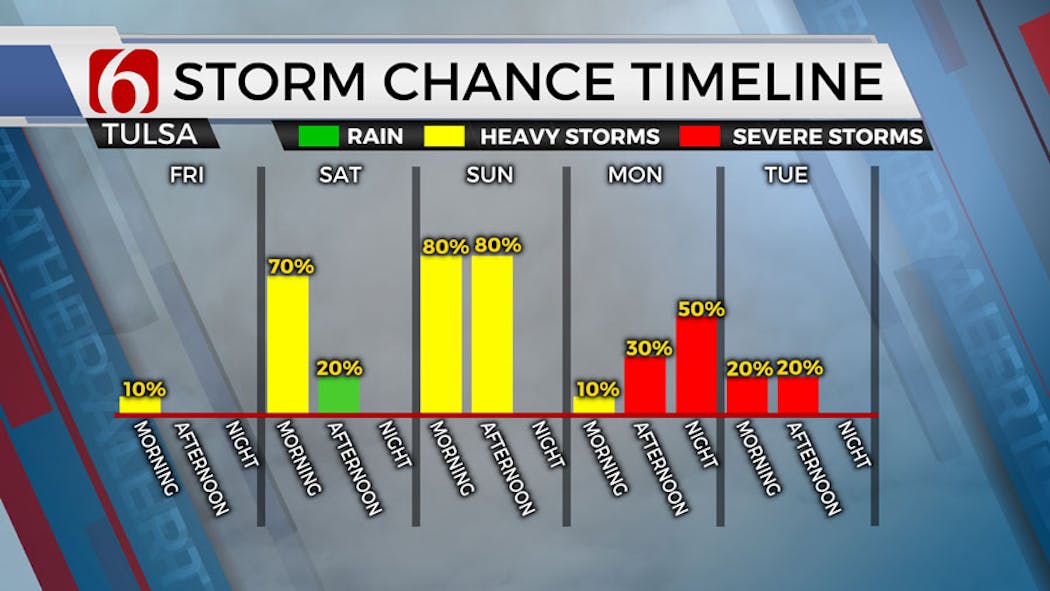
This weekend will have decent opportunities for showers and storms both Saturday and Sunday, including the mention for a few strong to severe storms.
A much stronger upper-level trough nears from the southwest early Monday into Tuesday with increasing threats of potentially more high-end severe weather threats.
Are there storm chances this weekend in Oklahoma?

Another wave of rain arrives on Sunday midday to afternoon, and triggering additional showers and storms near the area. The overall upper-level support seems weak and severe threats will be low but not zero Sunday.
After days of rain, much of western Oklahoma is under a flood watch.
What are the chances for severe weather next week in Oklahoma?
The powerful upper-level low nears the area late Sunday night into Monday and will eject to our northeast Monday night into Tuesday.
A dry line is likely to develop across far western OK with persistent southerly low-level flow bringing significantly deep moisture from Texas across Oklahoma into the central and northern plains.
As the strong system spreads upper-level winds nearing 90 knots across the area, thunderstorms will attempt to develop along and east of the dry line. All modes of severe weather will be likely.

A mitigating factor is the possibility of a layer of warm air aloft (the cap) which may limit updrafts for most of the day. By early evening, scattered storms may become more likely.
The stronger lift with the system exits into the Midwest Tuesday, but a broad upper flow from the west to east will remain positioned across the central plains.

At the surface, a slowly sagging frontal boundary is likely to be across part of our area keeping mentions for strong and severe storms both Tuesday and Wednesday across far part of eastern Oklahoma.
The front should finally clear our area by midweek with the possibility of some cooler and rain-free conditions next weekend.
The following roads are closed due to severe weather clean-up or flooding:
Cherokee County: SH-80 is closed approximately 3 miles west of Hulbert due to high water.
Cotton County: SH-5B is closed at Deep Red Creek between US-70 and SH-5A due to high water.
Outages Across Oklahoma:
Northeast Oklahoma has various power companies and electric co-operatives, many with overlapping areas of coverage. Below is a link to various outage maps.
Indian Electric Cooperative (IEC) Outage Map
Oklahoma Association of Electric Cooperatives Outage Map - (Note Several Smaller Co-ops Included)
The Alan Crone morning weather podcast link from Spotify:
https://open.spotify.com/episode/5j0ovActG8BZCOTqZQzrfU
The Alan Crone morning weather podcast link from Apple:
https://podcasts.apple.com/us/podcast/weather-out-the-door/id1499556141?i=1000646589555
Follow the News On 6 Meteorologists on Facebook!


Get The Daily Update!
Be among the first to get breaking news, weather, and general news updates from News on 6 delivered right to your inbox!
More Like This

May 5th, 2024

May 5th, 2024

May 5th, 2024

Top Headlines

May 5th, 2024

May 5th, 2024
May 5th, 2024

May 5th, 2024
