Odds of a White Christmas Explained.
A look at the odds of a White Christmas.Monday, December 17th 2012, 4:01 pm

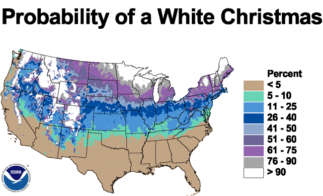
The map on the right requires some explanation. It shows the climatological probability of a White Christmas for any given year across the lower 48, but the definition of a White Christmas needs to be a part of this as well. The ‘official' definition of a White Christmas is for 1" of snow on the ground at the verification time of 6 AM Christmas Morning. So, just because some snow falls during the day or just because there is a trace on the ground left over from some previous snowfall, that does not meet the official definition.
At any rate, the map on the right does clearly show that a White Christmas is a very rare event for the state of Oklahoma with at most only a 10% chance for any given year. Also, as might be expected the chances increase with latitude.
Of course, this leads to the obvious question regarding having a White Christmas this year since it is just over a week away. Quite frankly, the jury is still out as the longer range guidance has shown considerable run to run inconsistency and there is a low confidence level regarding the timing/intensity/location of a strong system during the Mon-Wed time period. The latest and greatest guidance now suggests a chance of rain before the day is over on Monday, rain a good bet on Christmas Day itself, and depending on which set of guidance has the better solution, there is the possibility of a changeover to snow before the day is over or perhaps that night and into Wednesday. Again, the timing/intensity/location of this storm system may well change considerably with additional guidance over the next few days, so don't bet the farm on that scenario just yet.
In either event, it does appear that there will likely be some travel issues during that time period due to wet roads at the very least.
Between now and then, we will be very mild leading up to Christmas Day itself except on Thursday which will have a brief blast of cold, windy weather. Today has been milder than normal, and Tuesday and Wednesday look to be milder yet with daytime highs into the 60s. Overnight lows will be in the 30s tonight and near 40 Tue night which is also much milder than normal.
A rapidly moving cold front will be moving across the state late Wed/Wed night with strong S to SW winds ahead of it and even stronger NW winds behind it. That will create some fire danger concerns due to the windy, warm conditions. There will also be a chance of showers and possibly some thunder ahead of the cold front, but most of the rain and the better chances of thunder will likely be much further east of us. On the back side of the system, the colder air at the surface and aloft still look to be sufficient to wring out some brief periods of snow. There may even be a dusting as far south as the hwy 412 corridor, but any measurable accumulation still looks to be just across the state line into KS.
Thursday will then be a raw day with gusty NW winds, and despite the clearing skies temperatures will only be in the low-mid 40s during the day which is actually pretty close to normal. That will be followed by a return to mild conditions through the coming weekend and leading up to Christmas Day itself, which according to current guidance could turn out to be rather interesting.
So, stay tuned and check back for updates.
Dick Faurot

Get The Daily Update!
Be among the first to get breaking news, weather, and general news updates from News on 6 delivered right to your inbox!
More Like This
December 17th, 2012

April 15th, 2024

April 12th, 2024

March 14th, 2024
Top Headlines

April 23rd, 2024


April 23rd, 2024

April 23rd, 2024
