Cold Tonight, Followed by a Warming Trend.
Clear, cold night tonight. Warming trend through the weekend along with increasing chances of showers/storms this weekend.Tuesday, March 5th 2013, 2:32 pm


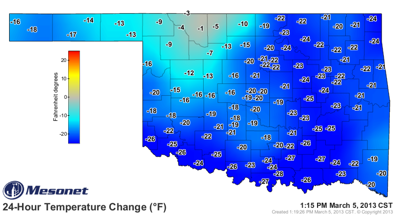
Spring time in OK can be marked by some pretty significant swings in temperature and that has certainly been the case over the last 24 hours. Notice the 24 hour change in temperature as of early this afternoon and as indicated by the first map on the right, courtesy of the OK Mesonet. Strong NW winds have also accompanied this particular system to make it feel even cooler. By the way, the reason for only a minimal change in NW OK from 24 hours ago is because of the snow on the ground that has kept them so much cooler than the rest of the state.
That will be changing this evening as the winds will settle down along about the time the sun goes down. For the overnight hours, light northerly winds, clear skies, and cool, dry air in place will result in a cold start to your Wednesday morning. Most of us will be dropping into the mid 20s to start the day after only reaching the upper 40s this afternoon.
A few high clouds during the day Wednesday will still allow for lots of sunshine and a more N to NE wind will only be on the order of 5-10 mph. That should result in afternoon temperatures reaching the lower 50s which is still well below the normal of 59 for this time of year.
However, the rest of the week and into the weekend will be above normal due to the return to gusty southerly winds in advance of a strong storm system that is heading our direction. We can also expect increasing cloud cover for the weekend along with increasing chances of showers/storms.
Notice the updated QPF map also on the right. Have been keeping a close eye on this over the last few days as this next storm system has the potential to be very wet. However, it has been trending down with respect to the total amount of rain we could expect to receive although another inch or so still isn't too bad. That is certainly subject to additional revisions over the next couple of days, so will continue to monitor that particular product.
The longer range guidance continues to project that storm system just mentioned coming through the Southern Rockies and into the Southern Plains over the course of the weekend. The guidance also continues to have some issues regarding placement/intensity/timing of that system; issues which have major implications regarding how much rain we can expect. Currently, the timing is strongly suggesting a late Saturday night/Sunday morning event for this side of the state with widespread showers/storms. Cannot rule out the possibility of some wintry precipitation on the backside Sunday night, but that does not look to be very significant at this point in time.
At any rate, this rainfall should put another dent into the ongoing drought situation.
In the meantime, stay tuned and check back for updates.
Dick Faurot

Get The Daily Update!
Be among the first to get breaking news, weather, and general news updates from News on 6 delivered right to your inbox!
More Like This
March 5th, 2013

April 15th, 2024

April 12th, 2024

March 14th, 2024
Top Headlines

April 19th, 2024

April 19th, 2024

April 19th, 2024

April 19th, 2024
