Turning Colder, Rain Likely.
Turning colder Monday, cold and wet Tuesday and Wednesday.Sunday, March 31st 2013, 8:48 pm

As mentioned in yesterday's discussion, had to make some big changes in the forecast at that time and the data coming in so far today has resulted in some additional fine tuning to those changes. We are still watching some much colder air that will be moving southward across the state on Monday, and the exact timing of this boundary will have a big impact on temperatures. The way I see it right now, the cold front should be reaching the immediate Tulsa area around the noon hour, give or take an hour or two. That should allow temperatures to moderate into at least the upper 50s if not the lower 60s by the time the colder air arrives. Then, gusty NE winds behind the cold front and mostly cloudy skies will result in temperatures dropping back into the lower 50s by 5PM and into the 40s that evening/night.
Obviously, if the front is delayed or comes through more quickly that will impact temperatures accordingly. Same thing applies for the more northern counties which will see the impact first and the more southern counties which are not expected to see much of an impact till later in the day.
After what has turned out to be a very pleasant Easter Sunday, the drier air that is now in place together with light winds and fair skies overnight should produce morning lows in the lower 40s. Then, temperatures will quickly rebound and should reach the 60s for those locations ahead of the cold front before falling back after frontal passage.
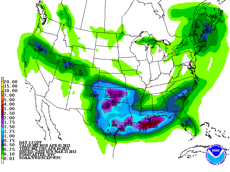
After that, Tuesday and Wednesday look to be downright cold and wet. In fact, as you can see from the QPF map on the right, which is valid through Wednesday, it is painting a rather generous picture. Hopefully that will verify as that kind of widespread rain will really put a dent in the drought situation.
We will also have very short thermometers those days with morning lows near 40 and daytime highs still in the 40s. The showers should be moving out Wednesday but it will still be quite cool followed by a return to southerly winds and much warmer conditions going into the coming weekend. Decided to keep temperatures steady on Sunday and there may be a few showers as there are indications of a weak boundary in the area by then.
After that, a more spring-like pattern looks to be getting established going into that following week with warm, windy, unsettled conditions possible.
So, stay tuned and check back for updates.
Dick Faurot

Get The Daily Update!
Be among the first to get breaking news, weather, and general news updates from News on 6 delivered right to your inbox!
More Like This
March 31st, 2013

April 15th, 2024

April 12th, 2024

March 14th, 2024
Top Headlines


April 19th, 2024


