Warmer Days Coming Our Way
<span lang="en-US"><font face="Calibri,sans-serif" size="2"><span style="font-size:11pt;">Will finally get rid of those stubborn low level clouds on Monday followed by generally warmer temperatures through the weekend and into the following week.</span></font></span>Sunday, December 7th 2014, 9:02 pm


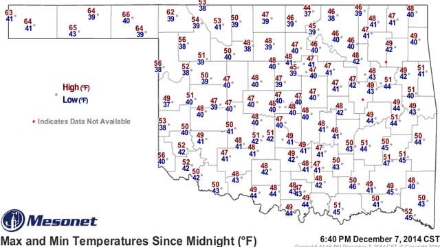
Notice today's max/min temperatures, courtesy of the OK Mesonet. Another very short thermometer as the cloud deck kept us from cooling off much at night and despite a light southerly breeze, the low level clouds also kept us from warming much during the day. Those low level clouds will persist through the overnight hours and with a light southerly breeze, do not expect temperatures to drop much by morning. Most of us should be in the low-mid 40s as that is also about where the dew point temperatures are at this time.
So far for the month of December, we have yet to see any sunshine as overcast skies have prevailed each day. That has kept us somewhat cooler than normal most of the days, but our nights have for the most part been warmer than normal because of the blanket effect of the clouds. Bottom line is that although the month has seemed to be rather cool so far because of the cooler days, we are actually averaging pretty close to normal because of the relatively warmer nights.
I mention that because the outlook for the coming work week and for the week following that is for above normal temperatures. The normal max/min temperature range for the coming week is around the 50/30 mark and from the forecast page you can see we expect to be at or well above those numbers each of the coming 7 days. One of the contributing factors for the milder temperatures will be the fact that we will finally get to see some sunshine for the first time this month.
That's right, I did not want to put that in the headline; afraid I might scare it off. But, the low clouds that will persist through the night and to start the day on Monday are expected to be thinning out by the Noon hour followed by lots of sunshine for the rest of the day. Tuesday will also be mostly sunny and we should at least start off the day on Wednesday with lots of sunshine.
A light southerly breeze tonight will be shifting to a light NW breeze during the day Monday as a weak frontal boundary pushes through the state. A NE wind on Tuesday will keep temperatures pretty close to normal, but the sunshine will sure be nice. After that, a more southerly wind will return and extend right on into the coming weekend accompanied by warmer nights and milder days.
Along with the southerly winds will likely be a return to more cloud cover for later in the week and the weekend along with perhaps some drizzle or a sprinkle or two. Notice I did not put a rain chance on those days as it appears it will be nothing more than that with the return southerly flow and little or nothing that would be measurable.
The longer range guidance does suggest a better chance of showers and possibly some thunder along about next Sunday. As is usually the case that far down the road, there is lots that can change but for now both the GFS and the ECWMF are suggesting the next system will be approaching by then. So, will be monitoring the data runs in the coming days to see if this signal remains consistent and also to get a better feel for the intensity as the preliminary indications suggest this system could be capable of producing some decent showers/storms.
Beyond that time frame, the guidance continues to suggest temperatures will average warmer than normal. Notice the 8-14 day temperature and precipitation outlooks which continue to suggest a very strong warmer than normal signal for much of the country. The outlook also suggests a relatively unsettled pattern for us which is not too surprising as the more zonal or W to E flow aloft will have embedded within it occasional pockets of energy capable of producing showers/thunder during that week long stretch.
So, stay tuned and check back for updates.
Dick Faurot

Get The Daily Update!
Be among the first to get breaking news, weather, and general news updates from News on 6 delivered right to your inbox!
More Like This
December 7th, 2014

April 15th, 2024

April 12th, 2024

March 14th, 2024
Top Headlines

 We Remember: City, State Leaders Expected To Assemble For Oklahoma City Bombing Remembrance Ceremony
April 19th, 2024

April 19th, 2024

April 18th, 2024
