Severe Weather Possible In Oklahoma This Week
<p>We are tracking two very strong storm systems over the next few days that will impact the Southern Plains and Oklahoma with increasing thunderstorm chances, some of which may be very strong to severe. </p>Monday, April 25th 2016, 4:14 am


We are tracking two very strong storm systems over the next few days that will impact the Southern Plains and Oklahoma with increasing thunderstorm chances, some of which may be very strong to severe.
One or two showers may occur this morning as a strong storm system ejects out into the Central and Northern High Plains.
This system was responsible for a few thunderstorms last night across South Central Kansas.
Later this afternoon, one or two isolated thunderstorms will be a very low possibility, but a layer of warm air aloft , commonly called the CAP, will more than likely keep thunderstorm activity from developing both today and tonight.
Any isolated storm that develops this afternoon or evening would be severe and capable of producing large hail.
Download our free news and weather apps
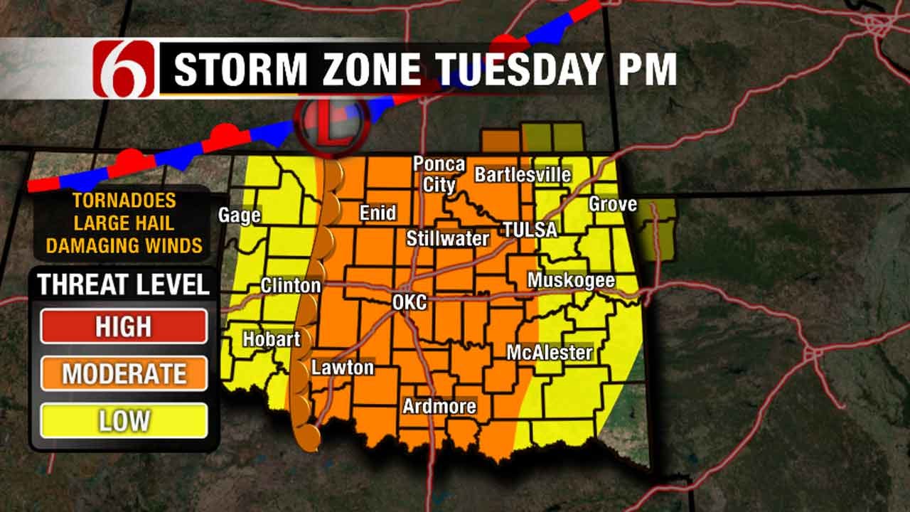
Tuesday morning, a few isolated thunderstorms may also be a possibility across far Northern Oklahoma and Southeastern Kansas as the very powerful upper-level storm system rotates across the four corners area. Warm moist air will rapidly spread northward across the Central and Southern Plains with gusty South Winds at 20 to 30 miles per hour. A dry line will this establish itself across part of Western Oklahoma and Southwestern Kansas associated with a surface area of low pressure.
Locations east of the dry line will become increasingly unstable with time Tuesday afternoon and evening.
See the latest watches and warnings
As the four corners area of low pressure begins to the left to the east-northeast, forcing along the dry line will allow thunderstorms to develop Tuesday evening into Wednesday morning. Thunderstorms will be scattered, but would be able to produce all modes of severe weather. Large hail, damaging winds, and tornadoes will be a possibility Tuesday night into early Wednesday morning. Wednesday morning thunderstorms may continue to move eastward, with additional thunderstorm activity developing Wednesday afternoon along or ahead of Highway 69 as the dry line moves East and Southeast across the state. These thunderstorms may also be strong to severe with very large hail and damaging winds the primary threats.
The cold front may pass Southeastern Oklahoma Wednesday night into Thursday morning allowing a short break for the state Thursday with sunshine and relatively mild conditions. Another strong upper level system will develop across the desert Southwest Thursday and the front will move northward as a warm front Friday and Saturday across Oklahoma and part of Kansas. Showers and thunderstorms will become more numerous during this time. And severe weather chances will also be increasing as this next storm system approaches the state. Unsettled weather with increasing thunderstorm chances will remain in the forecast Friday through the first half of the weekend. This 2nd system should clear the state sometime Saturday afternoon or evening with cooler and dry conditions expected Sunday.
Temperatures today will move into the lower 80s with strong South Winds and partly to mostly cloudy conditions. Some sunshine may occur later this afternoon. Temperatures will be characterized by lows in the 60s and highs in the lower 80s Tuesday with strong South Winds and increasing thunderstorm chances Tuesday night, including the threat of severe weather.
Wednesday another chance for thunderstorm activity will remain through the morning in northeastern OK, and into the afternoon across far southeastern OK and east central sections of the state. Additional severe thunderstorm activity will be possible across the far southeastern third of the state.
Thursday morning lows will be in the mid-50s. The afternoon highs will stay in the mid to upper 70s with northeast winds at 10 mph and mostly sunny sky.
Friday expect increasing clouds and gusty south winds with highs in the 70s along with increasing thunderstorm chances. The storm chances will remain Saturday into Sunday morning across central and eastern OK. Some of the storms may be severe. Weekend temperatures will feature lows in the 60s Saturday with highs in the mid-70s. Sunday morning lows in the 50s will be followed by highs in the upper 60s or lower 70s.
Thanks for reading the Monday morning weather discussion and blog.
Have a super great day
Alan Crone
KOTV

Get The Daily Update!
Be among the first to get breaking news, weather, and general news updates from News on 6 delivered right to your inbox!
More Like This
April 25th, 2016

April 15th, 2024

April 12th, 2024

March 14th, 2024
Top Headlines

April 23rd, 2024

April 23rd, 2024

April 23rd, 2024

