Storms, Heavy Rain, Ahead Of Great Weekend Weather
<p>A few storms will continue along the OK-Kansas state line for the next few hours but should quickly lift northeast away from the area this morning leaving warm and muggy conditions for all of eastern OK. Daytime highs will move back into the mid to upper-90s along with heat index values near 104. </p>Friday, September 9th 2016, 4:09 am


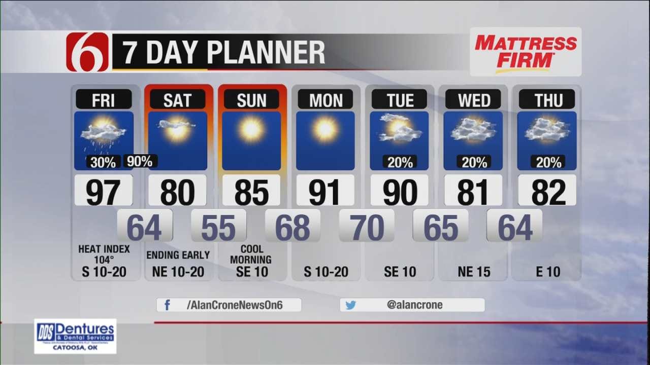
A few storms will continue along the OK-Kansas state line for the next few hours but should quickly lift northeast away from the area this morning leaving warm and muggy conditions for all of eastern OK. Daytime highs will move back into the mid to upper-90s along with heat index values near 104. But a strong cold front will sweep across the area late tonight through pre-dawn Saturday bringing a round of showers and storms followed by nice fall weather Saturday and Sunday. Another minor warm-up will occur Monday before the next front will arrive either Tuesday or Wednesday of next week with additional storm chances and another noticeable cool-down.
The activity this morning is near a weak boundary currently located across southern Kansas. Tropical moisture is being feed into this system with heavy rainfall in some locations across southeastern Kansas. This boundary will lift northeast quickly this morning and take the active weather away from the area. A few outflow boundaries may be present this morning and today across part of northeastern OK that may spark off a few storms. This pop will remain around 20% with muggy and warm conditions remaining across the area. The hi-res models indicate we could see a storm in the metro from this outflow boundary around 7am-8am but the chance will continue to remain low.
Tonight a strong upper level trough will rapidly eject across the Rockies into the central plains with a surface front quickly surging southward into the state. Storms will be likely along and slightly behind this boundary. A few strong to severe storms will be possible with damaging winds and heavy rainfall the main threat. The timing continues to support an arrival of the front around 9pm to 10pm in the metro with the front exiting southeastern OK tomorrow morning around 7am to 10am. The best chance for showers and storms will fall between these two times. Currently most Friday Night Football games will be ending before the storms arrive, but locations northwest of the metro may have the 2nd half interrupted by incoming storms. There is always a chance the front will speed up or slow down. Bottom line: remain aware of the weather tonight.
Dry and stable air will quickly follow the frontal departure Saturday with clouds clearing from the north to south by mid-morning. Saturday morning lows in the mid to upper 60s will be followed by highs near 80 with sunshine and north winds at 10 to 15 mph. Dry air will be noticeable.
Stay Connected With The News On 6
Sunday morning temperatures are expected to in the lower to mid-50s with clear sky, light winds, and dry air across eastern OK. Sunday afternoon highs will move into the mid-80s along with sunshine and east to southeast winds at 10 to 15 mph.
Monday morning lows in the 70s will be followed by highs in the lower 90s before the next front arrives either Tuesday or Wednesday of next week with additional storm chances and additional fall-like temperatures.
Thanks for reading the Friday morning weather Discussion and blog.
Have a super great day
Alan Crone

Get The Daily Update!
Be among the first to get breaking news, weather, and general news updates from News on 6 delivered right to your inbox!
More Like This
September 9th, 2016

April 15th, 2024

April 12th, 2024

March 14th, 2024
Top Headlines

April 16th, 2024

April 15th, 2024
April 15th, 2024

