Severe Weather Possible Across Eastern Oklahoma
<p>More warm and windy weather is expected today before a strong fall front moves across the area tonight bringing a chance of late afternoon and evening storms followed by cooler air for a few days this week. </p>Monday, October 9th 2017, 3:44 am


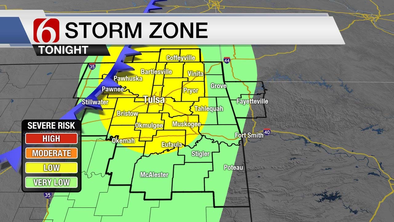
More warm and windy weather is expected today before a strong fall front moves across the area tonight bringing a chance of late afternoon and evening storms followed by cooler air for a few days this week. Another system will impact the area by the 2nd half of next weekend into early next week. Highs today will be in the upper 80s to lower 90s with highs Tuesday in the upper 50s to lower 60s. Some of the storms later this evening may be strong to severe.
The upper air flow is characterized with a strong positively tilted trough located near the four corners area this morning and quickly moving east to southeast. Later tonight into Tuesday this trough is expected to become more of a small closed low and rapidly move into central Kansas Tuesday morning and ejecting into the upper Midwest Tuesday afternoon into Wednesday. As this system deepens today a surface low pressure area will respond across NW Oklahoma and move eastward across the state this evening as a broad low pressure area. A surface front will continue moving southeast across the state later this evening with a chance of storms from southern Kansas into eastern Oklahoma. Adequate instability and severe weather parameters will be in place for a few hours this evening and some strong to severe storms will be possible. Objective skew-T analysis indicates the possibility for a few super cells across NE Oklahoma for a short period this evening before storms become more linear overnight. We’ll be in the running for all modes of severe weather for the first half of the event before convection attempts to line-out later tonight. It’s unclear on the exact coverage of storms this evening but we’ll keep a fairly high pop in place for locations along and east of highway 75. Storm timing appears between 3 pm to midnight. Metro timing would be around 5 pm to 9 pm. Most storms should be exiting the eastern Oklahoma state line region between midnight and 1 am.
The back side of the system may present some spotty showers for a short time Tuesday morning along with gusty north winds for the first half of the morning before wind speeds diminish in speed later during the early afternoon. The possibility of lingering clouds until later Tuesday would keep the highs in the upper 50s. The sky should clear sometime Tuesday later in the day with clear and chilly weather overnight into Wednesday morning. Dry air combined with clear sky and light winds will allow lows Wednesday morning in the 40s with highs rebounding into the mid to upper 60s with light wind and blue sky as a surface ridge of high pressure settles across north central Oklahoma. This ridge moves east Thursday as the next upper level trough begins to influence the state Thursday into the weekend with increasing south winds and warmer weather. We’ll see another warm-up Friday into next weekend before the next strong front arrives Sunday with storm chances and another decent cool-down.
Thanks for reading the Monday morning weather discussion and blog.

Get The Daily Update!
Be among the first to get breaking news, weather, and general news updates from News on 6 delivered right to your inbox!
More Like This
October 9th, 2017

April 15th, 2024

April 12th, 2024

March 14th, 2024
Top Headlines

April 25th, 2024


April 25th, 2024

April 25th, 2024
