Heat And Humidity Return To Eastern Oklahoma
<p>It looks like one more possible MCS will be brushing the area tonight before our attention quickly turns to the impending heat and humidity for the rest of the week. </p>Tuesday, June 26th 2018, 4:16 am


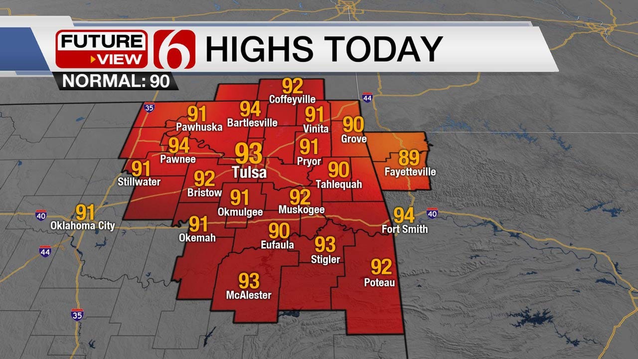
It looks like one more possible MCS will be brushing the area tonight before our attention quickly turns to the impending heat and humidity for the rest of the week. The recent rainfall (wet soil and green veggies) may offset the temperature potential by 1 or 2 degrees, but we’ll be in the upper 90s with THI valleys triggering heat advisories Wednesday and Thursday. Highs this afternoon will be from 92 to 95 with the metro around 93. Local dews may stay elevated today and could force the THI to near 101-103. The math tomorrow could take our high to 98 with a THI nearing 108 to 110. #ugh.
A weak boundary is located around the I-44 region this morning and will continue slowly lifting northward. Some subtle and weak forcing brushed this zone with a few showers and storms but the coverage has been very low. We’ll be in the running for a few morning showers and storms through pre-dawn but most of the day will be precip free.
Later this afternoon into tonight storms are likely to develop in several areas to our north (central plains into the Missouri Valley) and will have a tendency to grow upscale into one or more MCS ( storm complex) segments. While mid-level ridging is quickly expanding across north Texas into southwestern and central Oklahoma today, it will probably not be strong enough to override northeast Oklahoma until tomorrow. This means our northwest flow highway will brush our area for another evening.
One area of storms may quickly develop by this afternoon across eastern Kansas and spread into southwestern Missouri. By late afternoon and early evening, another area of storms may develop across south central or eastern Kansas and begin diving southeast late this evening. Tulsa may be on the far western edge of the pop but we’ll keep this mention for the metro due to the penitential. The main threats will be straight-line damaging winds from 60 to 70 mph along with heavy rainfall and some hail for southeastern Kansas and part of northeast Oklahoma. The timing is still up for grabs but appears to be late evening into early Wednesday morning.
Wednesday through Friday the ridge will be the big deal. This will keep the storms away and will bring the heat into the state. No doubt some of our friends across the western third of Oklahoma will see triple digits where the rainfall has been lower, but across our area, the recent rainfall “should” offset the temp by a few degrees. This process eventually stops and the heat wins. I’m just not sure if that takes place this week or possibly later next week, but we’re pretty close to seeing our first 100-degree day soon. The pattern will briefly change again this weekend with the ridge migrating away and a weak system bringing a few clouds along with some scattered storm chances Sunday into Monday. This process will lower our highs a few degree Sunday, but then the heat should return by the middle to end of next week.
Thanks for reading the Tuesday morning weather discussion and blog.

Get The Daily Update!
Be among the first to get breaking news, weather, and general news updates from News on 6 delivered right to your inbox!
More Like This
June 26th, 2018

April 15th, 2024

April 12th, 2024

March 14th, 2024
Top Headlines

April 17th, 2024

April 17th, 2024