October Begins with A Heat Wave, Turns Unsettled
As we flip the calendar to October, you would think there’d be a hint of cool fall air. Instead, we are greeted by high humidity and warmth, typical of May and June. We are heading into another warm spell that could qualify as an October heat wave. Some may even call it Indian Summer, but I think it must actually feel like fall for more than two days at a time before we can label it that. Instead, it’s just summer’s stubborn refusal to leave Oklahoma for good. The w...Monday, October 1st 2018, 1:43 pm


As we flip the calendar to October, you would think there’d be a hint of cool fall air. Instead, we are greeted by high humidity and warmth, typical of May and June. We are heading into another warm spell that could qualify as an October heat wave. Some may even call it Indian Summer, but I think it must actually feel like fall for more than two days at a time before we can label it that. Instead, it’s just summer’s stubborn refusal to leave Oklahoma for good.
The warm-up will be gradual into midweek, owing to quite a few morning clouds each day. However, any sunshine at all will propel us into the 80s. By Thursday, warm enough air brought by strengthening southerly winds could send the mercury up to 90°! That’s not a record, but nearly 15° above normal. What’s even more impressive is that morning temperatures may not even dip below 70° after Tuesday for a full week. That could put us in record territory there.
[img]
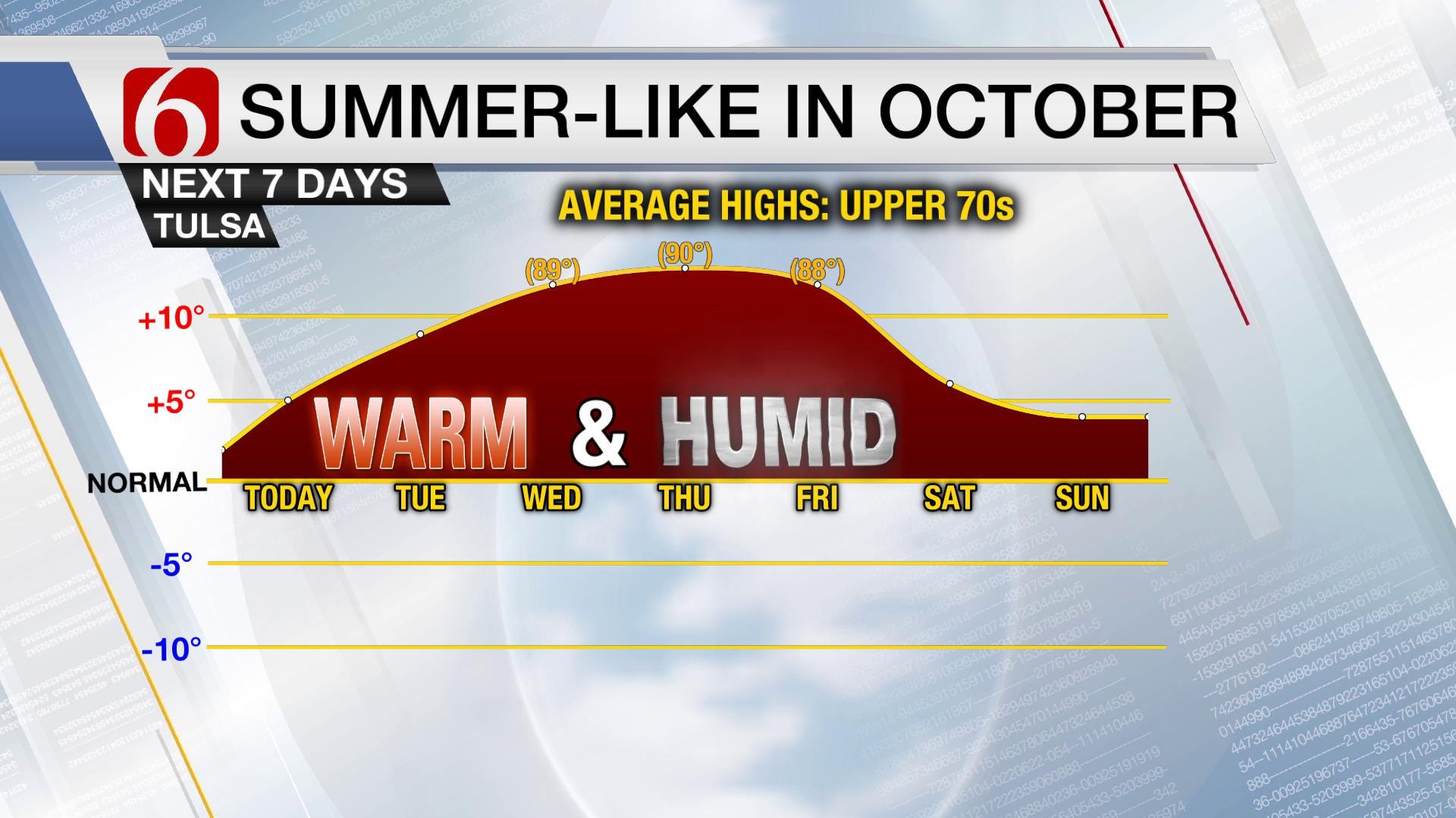
Above is that temperature trend through the weekend. This shows how far our daytime highs will be from normal. Even with more clouds and rain potential by late in the week, it still won’t really feel like fall. Here’s why: an unusually strong high pressure ridge setting up to our east is blocking any colder air from dropping into Oklahoma. Although there is a deep storm system developing across the western U.S. this week, it won’t be able to advance too far eastward as shown below. That keeps us and much of the Lower 48 for that matter in a summer-like pattern.
[img]
After our warm spell comes a wet spell. As you also see above, the jet stream will be edging closer by the weekend. That means the storm track will be able to translate this humidity into actual rain and storms. However, due to the nearly stalled out system, it may bring days of heavy rainfall to the state. Rain could fall as early as Friday night in Green Country, but the heavier and more prolonged bouts of rain may hold off until late in the weekend and early next week. From the weekend into next week may be a very active stretch of weather for much of the country. As you see below, it’s a wet outlook for nearly the whole country until mid-month. We could see several inches of rainfall during this time.
[img]
What about the real-deal fall air? It may be at least a week before its felt in our corner of the world, but it may be quite a whiplash. Even if we drop to average temperatures, we’d see lows down to 50° regularly. You can stow away the jackets for now, but a wardrobe change is likely next week. For more weather updates, be sure to follow me on Twitter: @GroganontheGO and on my Facebook Page!

Get The Daily Update!
Be among the first to get breaking news, weather, and general news updates from News on 6 delivered right to your inbox!
More Like This
October 1st, 2018

April 15th, 2024

April 12th, 2024

March 14th, 2024
Top Headlines

April 16th, 2024


April 16th, 2024

April 15th, 2024
