Alan Crone's Weather Blog: Winter Weather Advisory In Effect In Oklahoma
Periods of rain, freezing rain, sleet and snow will be likely with some accumulations possible along and west of the highway 75 corridor later this afternoon and early evening.Tuesday, February 19th 2019, 9:29 am
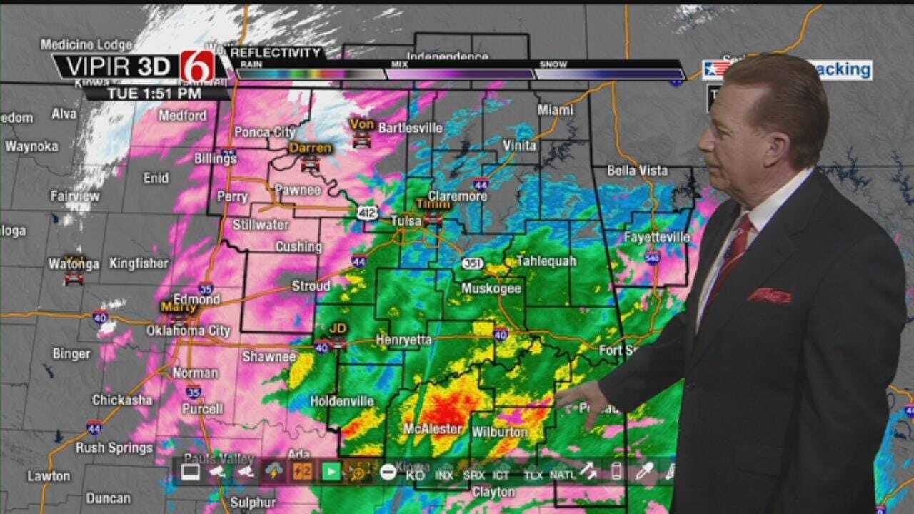
A winter weather advisory will remain for part of northeastern and central OK along with southern Kansas through the day and evening. Periods of rain, freezing rain, sleet and snow will be likely with some accumulations possible along and west of the highway 75 corridor later this afternoon and early evening. The predominate precipitation type across southeastern OK and north Texas will remain rain.

The Tulsa metro will see a mix of rain, sleet and possibly some light snow that may result in slick roadway conditions for the evening commute. There is a low chance that rain could remain the predominate precipitation type in the metro for this event but we do have a mix in the forecast
The entire system will be exiting the area later tonight, but some freezing drizzle may develop overnight into pre-dawn Wednesday for a short period. Cold weather will remain Wednesday morning, but clouds will slowly decrease through the afternoon with highs moving into the lower or mid-40s.
Improvement is likely with our temperatures by the end of the week as another storm system nears the state. But this will also result in shower chances Friday and thunderstorm chances Saturday. A few strong to severe storms may be possible Saturday across part of southeastern and eastern OK before another front moves across the region.
A strong upper level system is located to our west this morning but is spreading moisture up and over the shallow cold air entrenched across the state. A few spotty showers or pockets of drizzle will become possible this morning to our south with gradually increasing shower chances by late morning, mostly across southern OK. The metro chances will begin increasing around the noon hour with the best chance between 2pm and 7pm tonight. We’ll see rain showers nearing the metro first and possibly mixing with some sleet or even snow by later this afternoon.
Different parts of the state will support different precipitation types today with locations across north central OK along and northwest of the I-44 corridor mostly snow. This will also extend northward across a large portion of Kansas. Locations along or northwest of the I-44 corridor may see snowfall from 1 to near 2 inches of snow with the higher accumulations along the OK- Kansas state line region. Snowfall across southern to central Kansas will result in accumulations from 3 to 5 inches.
The Tulsa metro region may see spotty showers (rain) early afternoon transitioning to some sleet mixed with light snow for the evening commute. The longer the transition from rain to sleet occurs, the lower accumulations will be likely. Accumulations may be near or less than 1 inch for the metro region.
While amounts may not be exceeding large, any amounts of wintry mix may result in slick and hazardous travel for the advisory locations.
The main slug of moisture will exit the area this evening between 7pm and 10pm but pockets of drizzle may develop as dry air begins to invade the lower levels of the atmosphere with temps near or slightly below freezing across northern OK and southeastern Kansas. Therefore, our friends at the National Weather Service will keep the advisory up for the overnight hours due to this probability of freezing drizzle in some locations.
Tomorrow morning we’re starting with clouds and temps in the lower 30s for morning lows with slowly decreasing clouds by afternoon as highs reach the lower or mid-40s. The pattern will support another strong trough to impact the state later this week with increasing south winds and warmer weather. Highs will reach the lower to mid-50s Thursday and Friday with a slight chance of showers Friday.
Saturday gusty south winds will bring moisture rapidly into the state as a surface low pressure area develops and moves across southeastern or south-central Kansas. A chance for strong to near severe storm may develop Saturday afternoon or early evening, mostly across southeastern OK by midday to afternoon. Highs Saturday could reach the lower 70s, but the presence of clouds and moisture will probably keep the highs in the 60s. A strong front moves across the state Saturday late with sunshine and cooler weather remaining Sunday with highs in the lower 50s.
The graphics include the current winter weather or travel advisory. Also, the first try at our hour by hour forecast for the metro and several snapshots of the future-view forecast for the afternoon and evening. I write "first try" because this will be a moving target later today. Additional changes are still possible for this system later today.

Get The Daily Update!
Be among the first to get breaking news, weather, and general news updates from News on 6 delivered right to your inbox!
More Like This
February 19th, 2019

April 15th, 2024

April 12th, 2024

March 14th, 2024
Top Headlines

April 19th, 2024

April 19th, 2024

