Rain Moving Out But An Extremely Windy Saturday Ahead
Early morning showers and storms are quickly clearing out of Green Country this morning, but buckle up: Our Saturday weather will still be wild!Saturday, February 23rd 2019, 8:58 am
Early morning showers and storms are quickly clearing out of Green Country this morning, but buckle up: Our Saturday weather will still be wild!

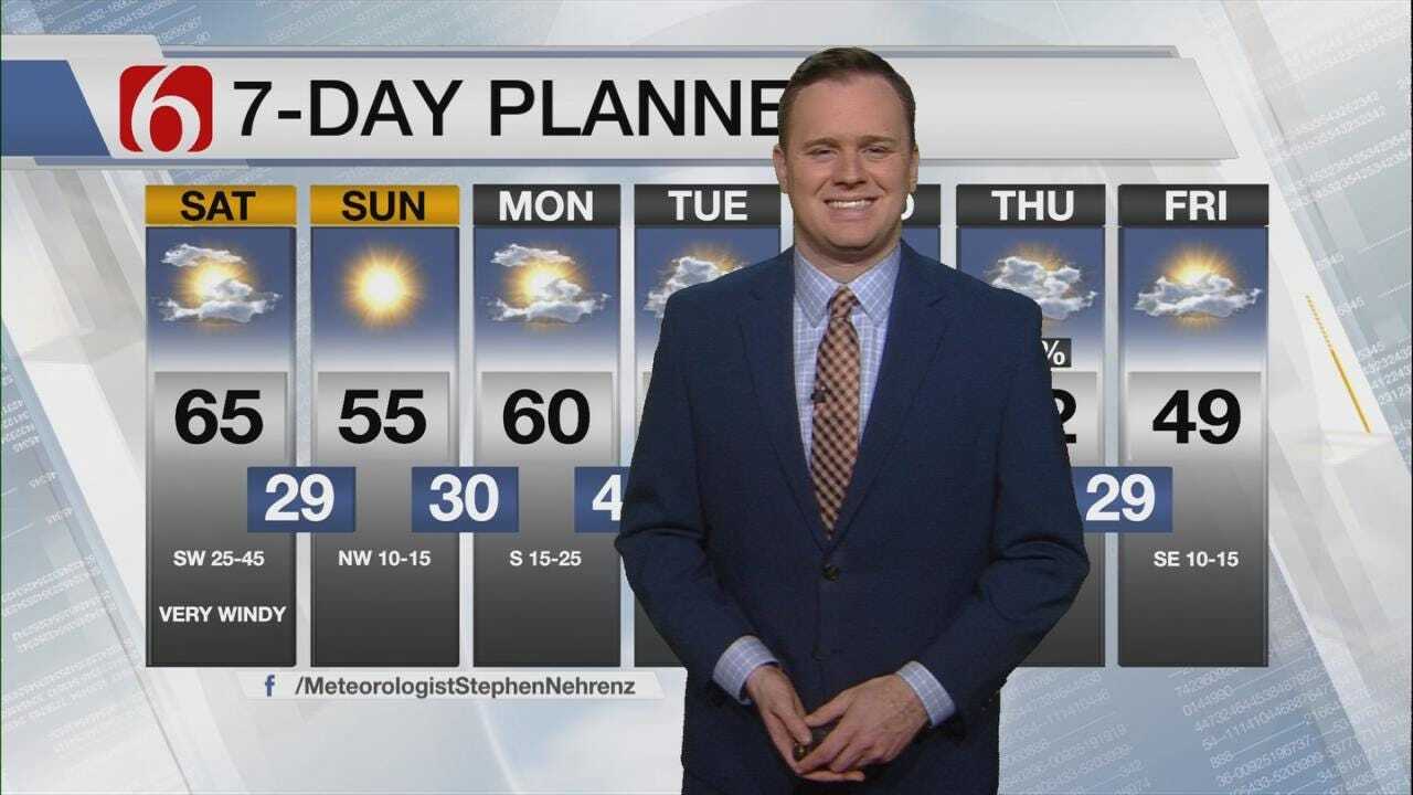
Showers, storms, and areas of dense fog will all rapidly clear out of eastern Oklahoma by the mid-morning hours. And sunshine looks to quickly return for late morning into the afternoon, with early afternoon temperatures soaring into the 60s today! Now those temperatures sound great, but it will come with a price: Some extreme winds.
Southwest winds will be gusting up to 45 miles per hour from late morning into the afternoon hours! Fire danger will be very high and driving could be a bit difficult. A cold front arrives by late afternoon, bringing a switch to more northwesterly winds which will continue to howl with gusts over 40 miles per hour into the evening hours.

Temperatures will also drop sharply by late afternoon and early evening behind that front, so be sure to have a coat handy later this evening even though our afternoon temperatures will be quite mild. We could also see one last band of brief passing showers across southeast Kansas and far northeast Oklahoma during the late afternoon hours as that cold front surges through.
Thankfully our extreme winds will begin to gradually settle down as we head into Sunday morning, but it will be a much colder start with lows in the upper 20s and wind chills in the lower 20s. Sunday will turn out to be a MUCH more pleasant day for us with lots of sunshine, winds continuing to diminish, and highs in the 50s!
Above normal temperatures will continue to start the work week, with another pleasant day setting up for us on Monday. We’re looking for highs pushing back towards 60 or the low 60s on Monday, though south winds will once again be increasing.
Another cold front will begin to approach Green Country on Tuesday, with clouds increasing. Right now it appears that front will hang in our northern counties north of Tulsa on Tuesday with temperatures in the 50s and low 60s south of Tulsa, but be aware that Tuesday’s forecast could still shift noticeably cooler or noticeably warmer depending on where that stubborn front begins to set up. We’ll eventually see a bigger push from that front on Wednesday, with chillier air settling back in for mid to late next week.
I hope you have a great Saturday, Green Country! Be sure to follow me on Twitter @StephenNehrenz as well as my Facebook page Meteorologist Stephen Nehrenz to stay up to date with the very latest!

Get The Daily Update!
Be among the first to get breaking news, weather, and general news updates from News on 6 delivered right to your inbox!
More Like This
February 23rd, 2019

April 15th, 2024

April 12th, 2024

March 14th, 2024
Top Headlines

April 18th, 2024

April 18th, 2024


