A Break From The Heat Arrives For Northeastern Oklahoma This Weekend
The cold front is south of the metro, but the upper level trough will remain nearby for the day bringing some morning showers before thinning out midday to early afternoon. Cooler weather will remain, with highs only in the upper 70s to lower 80s this afternoon.Friday, July 31st 2020, 6:31 am

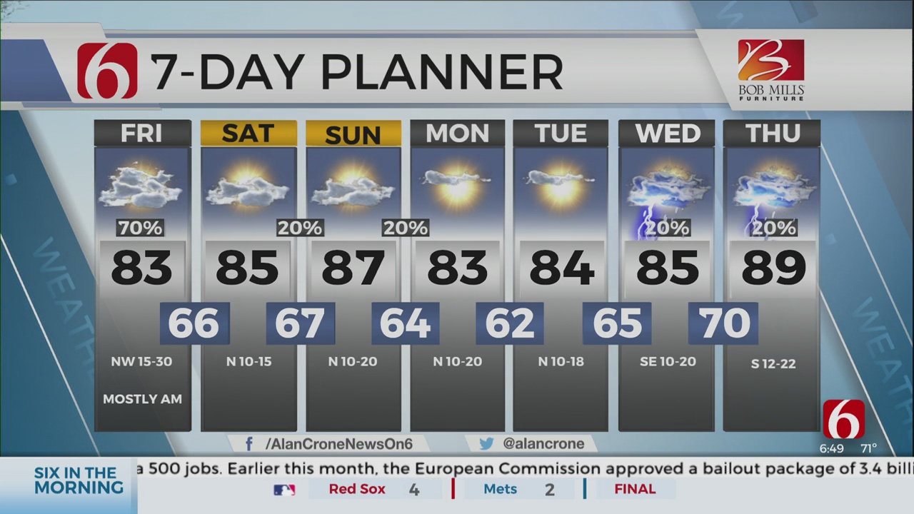
The cold front is south of the metro, but the upper level trough will remain nearby for the day bringing some morning showers before thinning out midday to early afternoon. Cooler weather will remain, with highs only in the upper 70s to lower 80s this afternoon.

Additional rain will develop this morning as part of the trough pivots across northeastern OK. This activity will promote some moderate rainfall in some locations, but with limited instability, very little lightning will be anticipated, and severe weather threats are not expected. After some morning rain nearby, activity will become isolated east of the metro through the afternoon as the main upper level trough pivots across the Missouri Valley before exiting the area later tonight. Temperatures behind the system will remain much cooler today with highs only reaching the upper 70s to lower 80s along with gusty northwest winds from 15 to 30 mph. The airmass will gradually begin to experience slightly drier air as the tropical moisture moves eastward. This will bring a welcome change this weekend continuing next week with temperatures below seasonal averages and no major heat index values. A nice respite from what is normally considered the hottest time of the year across northeastern OK.

The upper air pattern remains with a ridge west of the state and the upper air flow characterized by a strong northwest upper air flow across the plains. A few small showers may occur Saturday evening into Sunday, while another weak system could arrive Sunday evening with a few additional storms near or east of the metro. As long the northwest flow remains, we’ll be vulnerable for a few systems nearby, including either Wednesday or Thursday of next week.

Metro lows this weekend will drop into the mid-60s with highs in the lower to mid-80s. Early next week, it’s possible that a few valley locations may reach the upper 50s Tuesday morning while the metro starts in the lower 60s. Temperatures are expected to gradually warm back into the 90s by the end of next week as the mid-level ridge attempts to expand eastward.
Hurricane Isaias will continue to move into the Caribbean this weekend, approaching Florida and portions of the eastern U.S. coastline.
Thanks for reading the Friday morning weather discussion and blog.
Have a super great day!
Alan Crone

Get The Daily Update!
Be among the first to get breaking news, weather, and general news updates from News on 6 delivered right to your inbox!
More Like This


August 8th, 2023

July 4th, 2023

May 8th, 2023
Top Headlines

April 20th, 2024


