Early Morning Fog, Severe Weather Chances Move In Thursday Evening
Early morning fog can be expected. Storms move in on Thursday.Wednesday, May 26th 2021, 6:44 am
Some early morning fog and clouds should gradually thin out and reveal some sunshine later today with afternoon highs reaching the lower to mid-80s. While there may be a few isolated showers or storms in a few locations today, our focus continues Thursday, including the potential for significant severe weather probabilities as a cold front nears the state.

The upper air flow changes today and the impact will be noticeable in several areas regarding our sensible weather. First, the massive cloud deck we've been experiencing for the past week or so will gradually thin out today with some sunshine and warmer weather returning. But the tropical low-level moisture will remain. Clouds attempted to clear overnight but this tropical air mass quickly supported fog developing early this morning. This will create some muggy weather through the day with afternoon highs reaching the mid-80s along with south winds near 10 to 20 mph. We'll be feeling every bit of this moisture this afternoon and tomorrow. A few isolated showers or storms can’t be ruled out today, but we have no major focusing mechanisms currently in place near the region other than a few outflow boundaries from southern Kansas moving into northern OK later today.

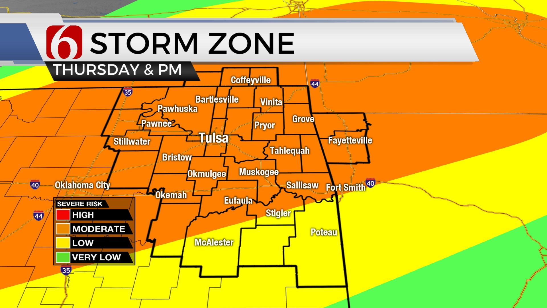
The second noticeable impact of the upper air change will occur Thursday and this arrives in the form of a cold front and severe storms by Thursday afternoon and evening.

Thursday morning we'll start with lows in the lower 70s to upper 60s and significant gulf moisture will be streaming northward in advance of our storm system. We may have clouds and even a shower or two early Thursday morning along the state line region in southern Kansas before partly cloudy and humid weather returns with highs reaching the upper 80s. The upper air flow brings stronger winds aloft southward, across central Kansas and northern OK by late Thursday evening as a mid-level trough passes across the central plains. At the surface, a cold front develops across central Kansas and will advance southward by late Thursday afternoon into far northern OK and southeastern Kansas. Most available data suggest very little cap (warm air aloft) will be in place and supercell thunderstorm formation will be possible as the front moves south and storms attempt to develop. This beginning phase, from 4 p.m. to 7 p.m., storms may produce very large hail, winds and even tornadoes in any discrete cells ahead of the boundary. Most data also quickly congeal storms into a long line of forward propagating storms that will be capable of producing a large swath of damaging wind, very heavy rainfall and some embedded circulations. The timing of this system would impact late Thursday afternoon and evening with storms exiting southeastern OK around midnight to 2 a.m. Friday morning.

Friday, the surface front will move south of the metro, but may briefly stall near or south of the I-40 corridor where some additional storms may develop with another upper-level impulse Friday evening. At this point, I think most, if not all this activity will remain away from our immediate areas of concern. This front will stay south, near or into the north Texas region for the weekend with most shower and storm activity either along the Red River Valley or across far western OK. Weekend temps will start in the mid to upper 50s and top out in the 70s.
The upper air flow brings another system near the state early next week, and thunderstorm chances will return by Monday night into early Tuesday across eastern OK.

Thanks for reading the Wednesday morning weather discussion and blog.
Have a super great day!
Alan Crone
KOTV
If you’re into podcasts, check out my daily weather update below. Search for NewsOn6 and ‘Weather Out The Door’ on most podcast providers, including Apple, Stitcher, Tune-In and down below on Spotify.


Get The Daily Update!
Be among the first to get breaking news, weather, and general news updates from News on 6 delivered right to your inbox!
More Like This

June 21st, 2023

June 19th, 2023

June 13th, 2023
Top Headlines

April 24th, 2024

April 24th, 2024

April 24th, 2024