Windy & Warm Before The Return of Wintry Weather Issues
Warm temperatures return to Green Country on Friday before another round of winter weather moves in.Friday, January 27th 2023, 6:25 am
If you’re into podcasts or in a rush, check out my daily weather update. Search for NewsOn6 and ‘Weather Out The Door’ on most podcast providers, including Spotify, Stitcher and Tune-In, or Click Here to listen on Apple Podcasts.
TULSA, Okla. - Warm temperatures return to Green Country on Friday before another round of winter weather moves in.
Here are the details from News On 6 Meteorologist Alan Crone:

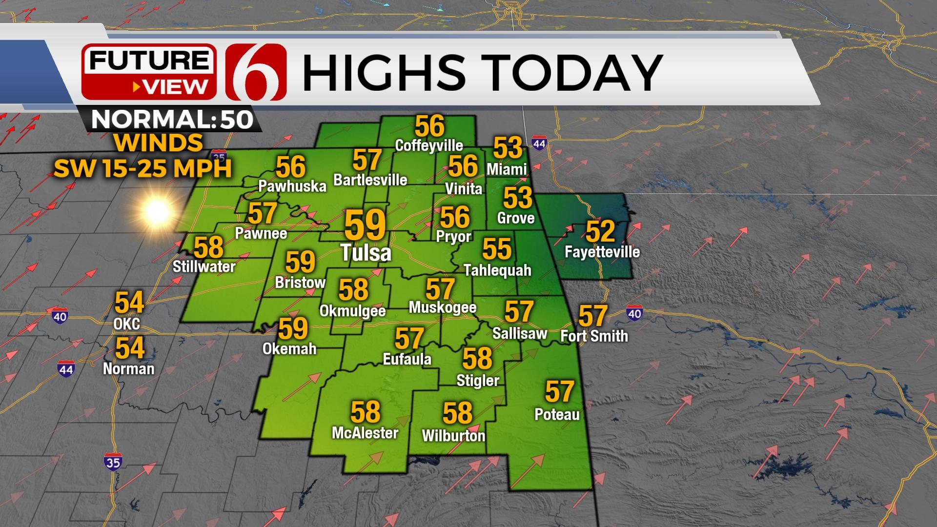
A mini-warming trend begins Friday with highs reaching the mid to upper-50s along with southwest winds at 15 to 25 mph. Mostly sunny conditions will remain Friday, but partly cloudy conditions arrive Saturday with afternoon highs nearing the upper 50s and lower 60s. The pressure gradient cranks up with strong south winds Saturday from 25 to 35 mph. Wind advisories may be possible. Despite recent rainfall and snow, the fire spread rates will be increasing both Friday and Saturday before the pattern brings much colder weather Sunday into next week. The potential for wintry weather impacts will arrive early next week.

The cold air intrusion begins late Saturday evening as a strong arctic ( shallow) cold front moves across the area. Moisture pooling across far southeastern OK and northeast TX may provide a few scattered showers or storms Saturday evening but the probability for most of our area seems low. As the front quickly moves southeast, a small window will remain for moisture to move up and over the shallow cold air resulting in a small area of freezing drizzle following the front into pre-dawn Sunday as temps drop below freezing. Higher chances for wintry weather impacts arrive Monday into Tuesday, and possibly again Wednesday evening into Thursday.

As the shallow cold air remains across the state, a developing upper-level trough across the southwestern U.S. will move slowly northeast while bringing relatively warm and moist air up and over the cold dome at the surface. This pattern usually brings a chance for freezing rain (ice) issues depending upon the exact depth of the cold air. Locations across the far northern sections may see a mix of sleet and snow. Far southeastern OK could be mostly a cold rain while areas from southwestern Ok through central sections into part of northeastern OK may support a mix of freezing rain or sleet with this pattern. Its impossible to depict with any certainty where these exact precip types will occur at this point, but the pattern will support all modes of wintry precipitation for early next week. As we draw closer to these periods, more specifics regarding precipitation types and timelines will be refined. The initial wave Monday appears to produce mostly light precipitation. As the main forcing approaches by the middle of the week, intensity and coverage is expected to increase.

Thanks for reading the Friday morning weather discussion and blog.
Have a super great day!
Alan Crone
KOTV

Get The Daily Update!
Be among the first to get breaking news, weather, and general news updates from News on 6 delivered right to your inbox!
More Like This
January 27th, 2023

June 21st, 2023

June 19th, 2023

June 13th, 2023
Top Headlines

April 24th, 2024
April 24th, 2024

April 24th, 2024

