Dry Week Ahead.
Clear and cool for tonight, but the rest of the week will be getting much warmer and will be dry.Monday, May 21st 2012, 3:12 pm


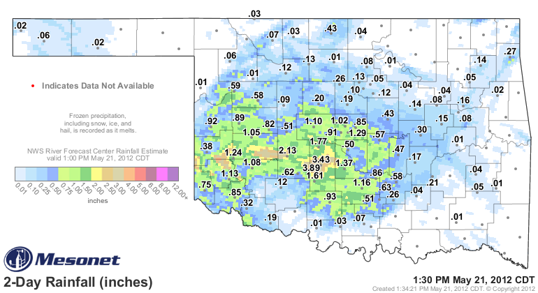
The first image on the right shows the statewide rainfall totals over the last 48 hours as compiled by the OK Mesonet. The SW corner of the state has been the winner this time around. The second image on the right is the QPF map showing the rainfall potential across the country and is valid though this coming Saturday morning. Notice the NE corner looks to be high and dry through that time frame as well. Bottom line is that we are dry and all indications suggest there is no real relief in sight through this forecast period.
At least we have had a brief break in the early season heat with temperatures near normal today and a clear, cool start expected for Tuesday morning. In fact, the normally cooler valley locations should be in the 40s to start the day tomorrow and here in Tulsa we expect to be near 50. The normal diurnal temperature range at this time of year is 81/61 for the high/low respectively, so Tuesday will start off much cooler than normal.
Not for long though as full sunshine during the day and a return to a SE wind should get us into the lower 80s that afternoon and even warmer for the rest of the week. In fact, daytime highs will be pushing the 90 degree mark for the latter part of the week and through the coming weekend. Our nights will also be getting warmer with morning lows in the lower 60s by Wed morning and upper 60s to near 70 for the rest of the week.
Strong southerly winds will also be a factor beginning on Wed when winds gusting to 30 mph or more are expected and that will likely be an issue for the rest of the week. Mostly sunny skies will be the general rule through the week as well with just some fair weather cumulus clouds during the day and generally fair overnight skies. As mentioned above, our chances for any rain is pretty much in the slim to none category for the rest of the week and that will likely extend through the coming weekend.
In fact, the longer range guidance suggests our next decent shot at rain will probably not be till the mid-latter part of the following week. In the meantime, above normal temperatures and gusty southerly winds will result in high evaporation rates and our soils and vegetation will continue to dry out. Not a good situation going into the summer months.
So, stay tuned and check back for updates.
Dick Faurot

Get The Daily Update!
Be among the first to get breaking news, weather, and general news updates from News on 6 delivered right to your inbox!
More Like This
May 21st, 2012

April 15th, 2024

April 12th, 2024

March 14th, 2024
Top Headlines

April 18th, 2024

April 18th, 2024

April 18th, 2024

