Cold and Wet Monday.
Cold and wet for Monday, some wintry precipitation possible into the day Tuesday.Sunday, December 30th 2012, 7:58 pm


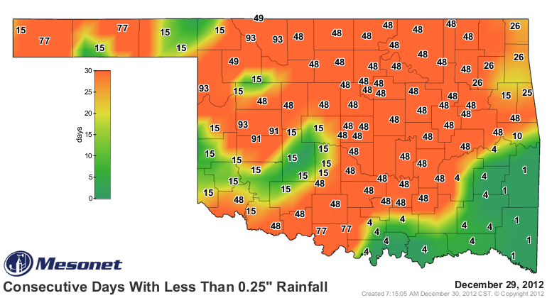
I referenced the number of consecutive days since most of us have received as much as ¼ inch of moisture in the morning discussion and that map is the first one on the right, courtesy of the OK Mesonet. Hopefully, the second map on the right will verify which is the QPF(Quantitative Precipitation Forecast) map for Monday and shows widespread rains of up to ½ inch and perhaps even more for some locations. Obviously, we desperately need the moisture and although this would not be a drought breaker by any stretch, it would at least put a little dent in the ongoing severe drought situation.
There are still some questions though regarding precipitation type for later tonight and into the morning hours of Monday. As the rains first start, there is a layer of drier and therefore potentially cooler air aloft which will evaporate much of the rain initially. However, that is also a cooling process and will bring the column of air above the surface close to the freezing mark for the late night and morning hours. Meanwhile, we will have southerly winds at the surface and a SW wind aloft, both of which typically produce at least some warm air advection. Obviously, these two processes are in opposition to one another which leads to considerable uncertainty regarding the precipitation type that we can expect for later tonight and to start the day on Monday.
At the present time the surface wet bulb temperature, which is a measure of how much the air can be cooled given the current temperature and moisture content, is at or just above freezing. Since the surface air should be moderating at least somewhat with the southerly winds, that should keep our surface temperatures just above the freezing mark tonight and Monday. At least that should eliminate the chances of freezing rain or drizzle to start the day. However, given the vertical profile of temperature and moisture, a rain/sleet/snow mix is certainly possible for at least a time Monday morning.
As the day wears on, somewhat warmer air will be advected in aloft and the air near the surface will hold just above freezing so most of what falls for much of the day will be in the form of a cold rain. However, later Monday night a cold front will be pushing across the state bringing surface temperatures back below freezing shortly after midnight and also bringing in colder air aloft. The deeper moisture is expected to be moving out as the colder air moves in, but there will be a window of opportunity for another bout of wintry weather late Monday night and into the morning hours of Tuesday. There may even be some light accumulations for the more northern counties. At any rate, any travel for Monday night and into the day Tuesday needs to account for the potential for icy roads, particularly on the bridges and overpasses.
This system should drop some decent snows across Central KS so that the northerly winds will have on New Years's Day together with mostly cloudy skies for much of the day will lead to a very cold, raw day. Look for temperatures to remain below normal for the rest of the coming week with a moderating trend starting in time for the weekend. Southerly winds and at least some sunshine should get us back into the 40s and perhaps even the lower 50s by Sunday.
In the meantime, stay tuned and check back for updates.
Dick Faurot

Get The Daily Update!
Be among the first to get breaking news, weather, and general news updates from News on 6 delivered right to your inbox!
More Like This
December 30th, 2012

April 15th, 2024

April 12th, 2024

March 14th, 2024
Top Headlines
April 25th, 2024

April 25th, 2024

April 25th, 2024

April 25th, 2024
