Records Set Again Today!
<p>Record setting temperatures across OK again today, but relief is on the way.</p>Monday, October 17th 2016, 8:10 pm


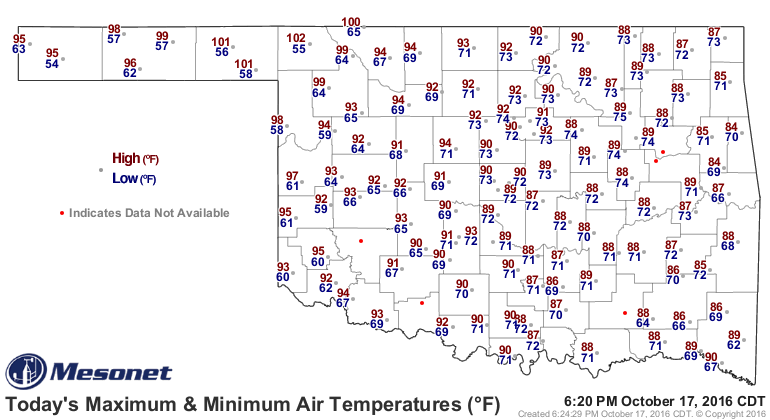
Hard to believe this is October. Notice the max/min temperature map across the state, courtesy of the OK Mesonet. Yep, triple digits in NW OK which is a record for the highest temperature to ever occur this late in the year for anywhere in the Sooner State. Notice also those morning lows, particularly here in E OK where we again set records for warmest morning low temperature after setting similar records Sunday morning.
[img]
In fact, this graph illustrates the ups and downs we have experienced recently. Thursday came within 3 degrees of setting a record for coolest daytime high when we were only in the 50s throughout the day. That was quickly followed by the big time warm-up that has extended through the day today. For Tulsa, we set a record for warmest morning low on Sunday morning and again this morning. Did not set a record Sunday afternoon despite the 89 degree reading and the 90 degree temperature recorded today ties the record for the warmest ever on this date. Keep in mind that our normal max/min for this time of year here in Tulsa is 73/50; in other words, our morning lows have been warmer than our normal daytime highs for crying out loud.
[img]
These record setting warm temperatures have also been accompanied by strong and gusty southerly winds over the last several days. Notice, for example, the maximum winds recorded so far today with many locations reporting wind gusts in excess of 40 mph and sustained winds have been consistently in the 20-30 mph range.
[img]
At least changes are on the way in the form of a cool front that will be arriving during the morning and into the afternoon hours of Tuesday. Problem is that this boundary is relatively weak and looks to stall out between the I-44 and I-40 corridors that afternoon. This will make a huge difference in temperatures depending on which side of the boundary you are located. The more northern counties will be in the 60s to start the day and should only climb into the 70s during the afternoon. The more southern counties will likely be in the upper 60s to low 70s to start the day and should make it into the 80s for the afternoon hours. Partly cloudy skies are also expected but no mention of rain at this time. Northerly winds behind the boundary and southerly winds ahead of it will not be as strong and gusty as has been the case for the last several days though.
Wednesday, that boundary is expected to drift back northward as a warm front by morning putting most of us back into the warm, humid air with morning lows in the upper 60s or low 70s again. But, that afternoon the boundary will finally get a bigger push back south and that is when there will be chances of showers/storms, particularly for the more SE counties late in the day and through the overnight hours.
Brisk northerly winds on Thursday will finally bring temperatures back to more fall-like values which will be the general rule through Friday and to start the day Saturday as you can see on our forecast page. Not for long though as a return to southerly winds will result in another warm-up over the course of the weekend and into early next week.
In fact, looking further down the road, the 8-14 day outlook continues with a strong signal suggesting warmer than normal conditions for OK for that last week of October. The long range outlook also suggests the potential for several additional rounds of shower/storms over that time frame; certainly hope that verifies as we sure could use the moisture.
[img]
[img]
So, stay tuned and check back for updates.
Dick Faurot

Get The Daily Update!
Be among the first to get breaking news, weather, and general news updates from News on 6 delivered right to your inbox!
More Like This
October 17th, 2016

April 15th, 2024

April 12th, 2024

March 14th, 2024
Top Headlines


April 19th, 2024

April 19th, 2024

April 19th, 2024
