Cold Pattern Taking Hold Again in the New Year
<p>On only the 2nd day of 2017, we are getting a taste of spring in Green Country. Temperatures are nearing 70° in many areas in the wake of morning showers and ahead of an Arctic front. However, this is a fleeting warm-up as frigid air is make a B-line for the state. </p>Monday, January 2nd 2017, 2:48 pm


On only the 2nd day of 2017, we are getting a taste of spring in Green Country. Temperatures are nearing 70° in many areas in the wake of morning showers and ahead of an Arctic front. However, this is a fleeting warm-up as frigid air is make a B-line for the state. The winds turn northerly late tonight as the cold front arrives. That will lead to a slow and steady drop in temperatures on Tuesday, bringing us below freezing that night. Some areas may not see readings above that mark until the weekend.
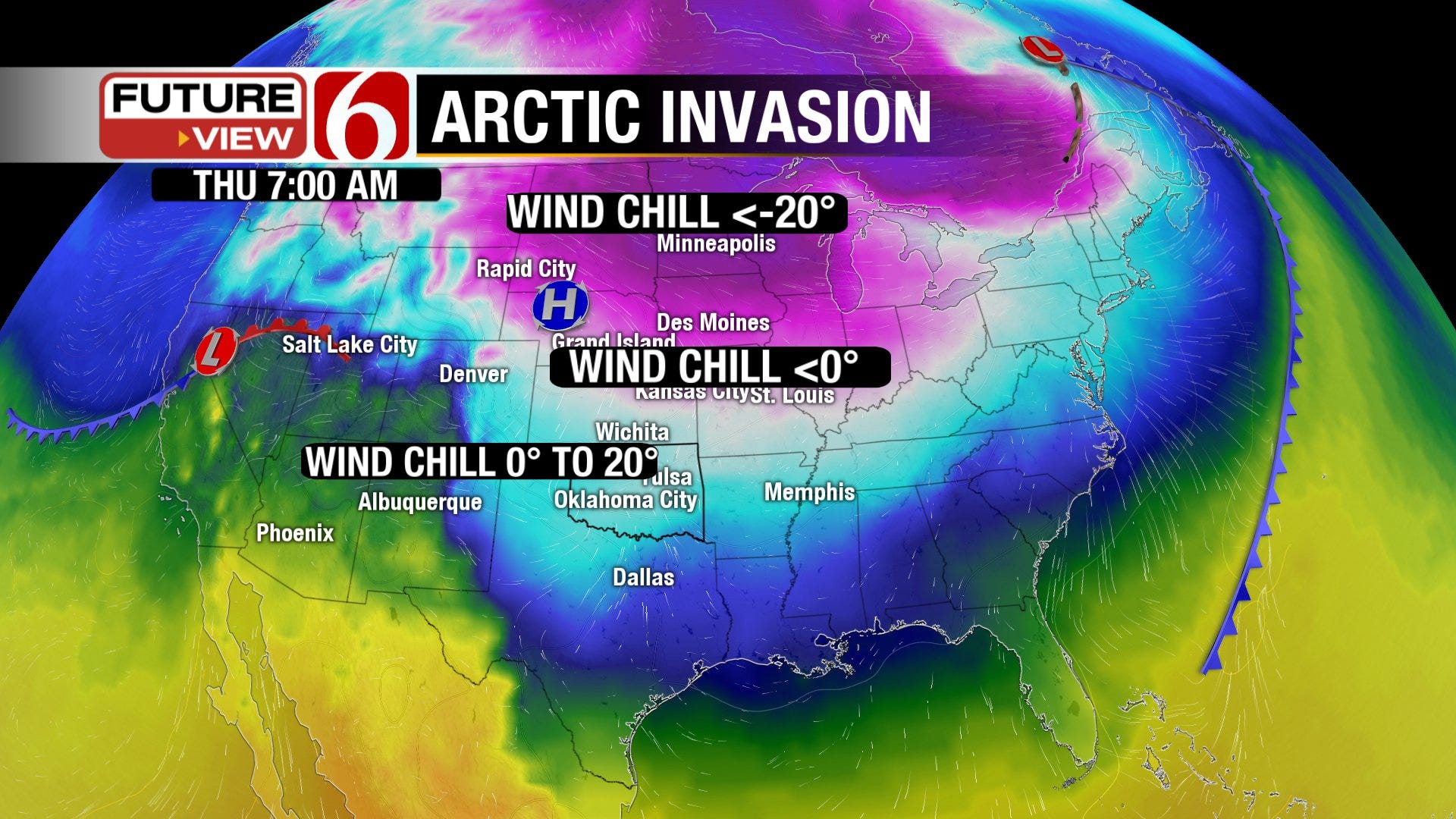
The cold spell won’t be quite as harsh as the one in mid-December. It will be tempered somewhat due to a lack of snow cover in our neighboring states to the north. However, the air will become increasingly cold midweek. An abundance of clouds overhead will further limit warming during the day starting Tuesday. This initial cold wave will come in dry with no storm systems to trigger snowfall. There is a small indication that a reinforcement of cold air on Thursday could lead to some flurries flying over Green Country. With meager moisture and limited forcing, any snow that does fall will be light… likely the kind that blows around on the roadways without much consequence. Snow or no snow, it will be frigid. Thursday morning wind chill values may be in the single digits! As you see on the map below though, it will be much colder for our friends in the Upper Midwest.
[img]
Bigger questions arise as we head into the weekend. Two of the most reliable computer models are at great odds with each other by Friday. One shows a gradual warm-up into the weekend while the other shows a snowstorm. Given the lack of consistency in the projections of the latter model, I have not given it much weight in our current forecast. However, it’s a trend to watch and some wintry weather cannot be ruled out at this point.
In any case, moisture will be welcome news for the state. 2016 ended with over a foot less rainfall than what is normal with just over 28” of liquid-equivalent precipitation. 2015 in contrast had over 60” of liquid-equivalent precipitation. This drop in moisture has put most of Oklahoma in a drought with the greatest deficits in southeast Oklahoma. January is normally our driest month of the year so help is often hard to come by. Fortunately, in the longer range outlook, a slightly wetter than normal pattern may be with us into mid-January. Even the 3 to 4 week outlook below shows a potentially active weather pattern for us. It is yet to be seen if that amounts to lots of wintry weather or not as the temperature trend is a bit less clear. It does appear to trend warmer after this week, but we are also at the coldest point in the year, climatologically speaking.
[img]
[img]
The bottom line is that the bottom falls out Tuesday as temperatures plunge well below-normal for several days. Wintry weather can’t be ruled out, but the chances for any significant impacts from that are very low at this time. Have the coats ready, the logs stacked close to the fireplace and the hot tea ready to brew. And be sure to follow me on Twitter: @GroganontheGO and on my Facebook Page for more weather updates!

Get The Daily Update!
Be among the first to get breaking news, weather, and general news updates from News on 6 delivered right to your inbox!
More Like This
January 2nd, 2017

April 15th, 2024

April 12th, 2024

March 14th, 2024
Top Headlines

April 19th, 2024

April 19th, 2024

April 19th, 2024

April 19th, 2024
