Temperature Roller Coaster Continues For Eastern Oklahoma
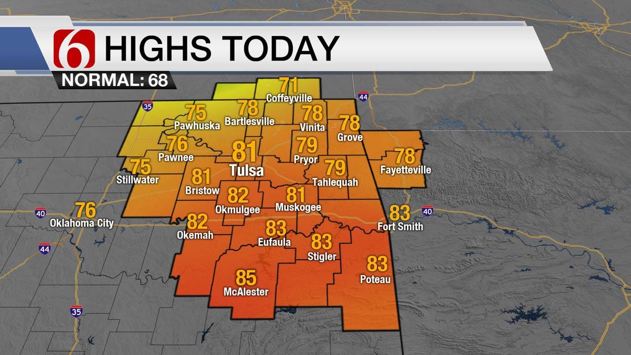
<p>The warming trend continues today with south to southwest winds and highs in the upper 70s to lower 80s. A front enters the state later this evening and stalls south of the metro and north of the I-40 corridor region.</p>Thursday, November 2nd 2017, 4:06 am


The warming trend continues today with south to southwest winds and highs in the upper 70s to lower 80s. A front enters the state later this evening and stalls south of the metro and north of the I-40 corridor region. This will bring temps down Friday along with a slight chance for a shower or two near us. A few isolated thunderstorms may develop across far southeastern Oklahoma and northeast Texas where deeper low-level moisture will reside. The positioning of the front is different in the various data and brings a low confidence into the forecast regarding temps for Friday and part of Saturday. Some data now will take the boundary more southward Friday and consequently keeps the highs in the upper 50s and lower 60s for northern Oklahoma with upper 60s to the south. These solutions also delay the return of the front northward until later in the day Saturday which would keep Saturdays highs in the upper 60s to lower 70s. The EURO and GFS would bring the front northward late Friday night into Saturday morning faster. This would result in our current set of numbers with Friday highs in the upper 60s near 70 and into the upper 70s Saturday and the lower 80s Sunday before the front moves southward again later Sunday night into Monday morning. Needless to say (or post) we do have some controversy in the potential temp forecast. I’m leaning toward lowering the Friday highs slightly but keeping the Saturday numbers into the upper 70s.
In the precipitation department, we’ll keep a slight mention of a few spotty showers or some drizzle Friday across northeastern Oklahoma while one or two isolated storms may develop in the deeper moisture of far southeastern Oklahoma and northeast Texas. The odds will remain low.
Another slight chance of showers or storms will remain for the late Sunday period as the front moves southward again into northeastern Oklahoma. A few storms will develop across the Missouri Valley and may back-build into far northeastern Oklahoma late Sunday into early Monday morning. This pop also remains very low.
The Sunday night and Monday morning front will eventually be reinforced by colder air for the middle of next week. Monday and Tuesdays highs will be in the lower 60s with the numbers dropping into the 50s for Wednesday afternoon highs.
In the short term, we’ll watch for some fog potential across far eastern Oklahoma and northwestern Arkansas as low-level moisture streams into the area. Wind speeds across eastern Oklahoma should keep this from being a big issue with the result of moisture being deposited on elevated surfaces. This pattern may also bring some stratus into the region early this morning. Most of this would be across far southeastern Oklahoma.
Thanks for reading the abbreviated Thursday morning weather discussion and blog.

Get The Daily Update!
Be among the first to get breaking news, weather, and general news updates from News on 6 delivered right to your inbox!
More Like This
November 2nd, 2017

April 15th, 2024

April 12th, 2024

March 14th, 2024
Top Headlines

April 24th, 2024
April 24th, 2024

April 24th, 2024

