Spring-Like Friday, But Rain Expected Saturday Evening
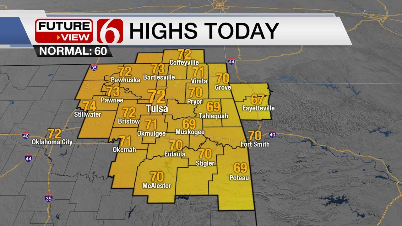
<p>We’re starting with clear and cool weather this morning and will move back into the upper 60s and lower 70s today with increasing south to southwest winds before clouds arrive later this afternoon and tonight in advance of the Saturday storm system.</p>Friday, March 9th 2018, 4:03 am


We’re starting with clear and cool weather this morning and will move back into the upper 60s and lower 70s today with increasing south to southwest winds before clouds arrive later this afternoon and tonight in advance of the Saturday storm system. As the system clears the area Saturday evening, gusty north winds will develop and continue through Sunday with cooler weather. Sundays temps should remain near 50 for the afternoon with partly cloudy conditions. The majority of next week appears rather uneventful, but we’ll need to watch some western energy on the back side of surface ridge for a few showers to our west. Our next major system will arrive by next weekend.
The upper air pattern remains from the northwest to southeast. The mean ridge across the inter mountain west will stay put for a few more days. A developing short-wave, now entering the pacific northwest, will drop down the northern Rockies and then into the central plains Saturday into Sunday while helping to produce weak lee-side cyclogenesis today. This low will move southeast with time and end up to our south Saturday midday to evening. After southwest winds for most of today, this will quickly induce southeast wind this evening with increasing stratus by afternoon and evening. Low level moisture will increase enough to combine with the 850 mb jet to produce scattered yet elevated convection after midnight into pre-dawn Saturday in a few spots across eastern Oklahoma. This activity is expected to remain on the cool-side of any true warm or quasi warm frontal boundary and could produce some small hail in spots along with some lightning. I’m planning to keep these pops around 40 to 50% but the confidence is still low this morning due to the spread in model data output regarding some important features. The positioning of the surface low Saturday continues to have differences in the various model spreads and could result in changes in the precipitation forecast for Saturday. The NAM and EURO are diving the low across Texas now with the GFS remaining closer to the Red River Valley. The impact would be a much lower coverage in the NAM and a more robust coverage with the GFS. Our forecast has continued to trend on the wet side but my confidence remains rather low at this hour regarding the specific location of the best rain and storm chances. I may knock the pop down slightly before game time today. But the confidence regarding the better location for severe weather across far southeastern Oklahoma and northeast Texas remains good. Any storm activity across northeastern Oklahoma, including the metro, would be marginally strong, at best, with the possibility of some small hail while storms across far southeast Oklahoma into southwest Arkansas could be closer to the true warm sector with a better chance for severe hail and wind. The absolute better location still appears to be across northeast Texas into the Pinewoods, southeast into Western Louisiana.
Most of the weather today will be fine with warmer and breezy weather. Then prepare for a few storms, but not in all locations Saturday. There will remain a chance that some folks around the metro to the west could stay dry. Sunday looks windy and cooler, and next week remains chilly before increasing temps by the middle to end of next week.
Thanks for reading the Friday morning weather discussion and blog.

Get The Daily Update!
Be among the first to get breaking news, weather, and general news updates from News on 6 delivered right to your inbox!
More Like This
March 9th, 2018

April 15th, 2024

April 12th, 2024

March 14th, 2024
Top Headlines

April 17th, 2024


April 17th, 2024

