August Turning Unsettled for Oklahoma
<p>A dry heat has turned into muggy mess yet again for Green Country. Today was the 65th day at or above 90° this summer, the 9th most 90°+ days year to date in Tulsa history. Heat index values rose well above the century mark on our Monday afternoon as well. Fortunately, that increase in atmospheric moisture is a precursor to wetter and, thus, cooler days ahead.</p>Monday, August 6th 2018, 7:36 pm


A dry heat has turned into muggy mess yet again for Green Country. Today was the 65th day at or above 90° this summer, the 9th most 90°+ days year to date in Tulsa history. Heat index values rose well above the century mark on our Monday afternoon as well. Fortunately, that increase in atmospheric moisture is a precursor to wetter and, thus, cooler days ahead.
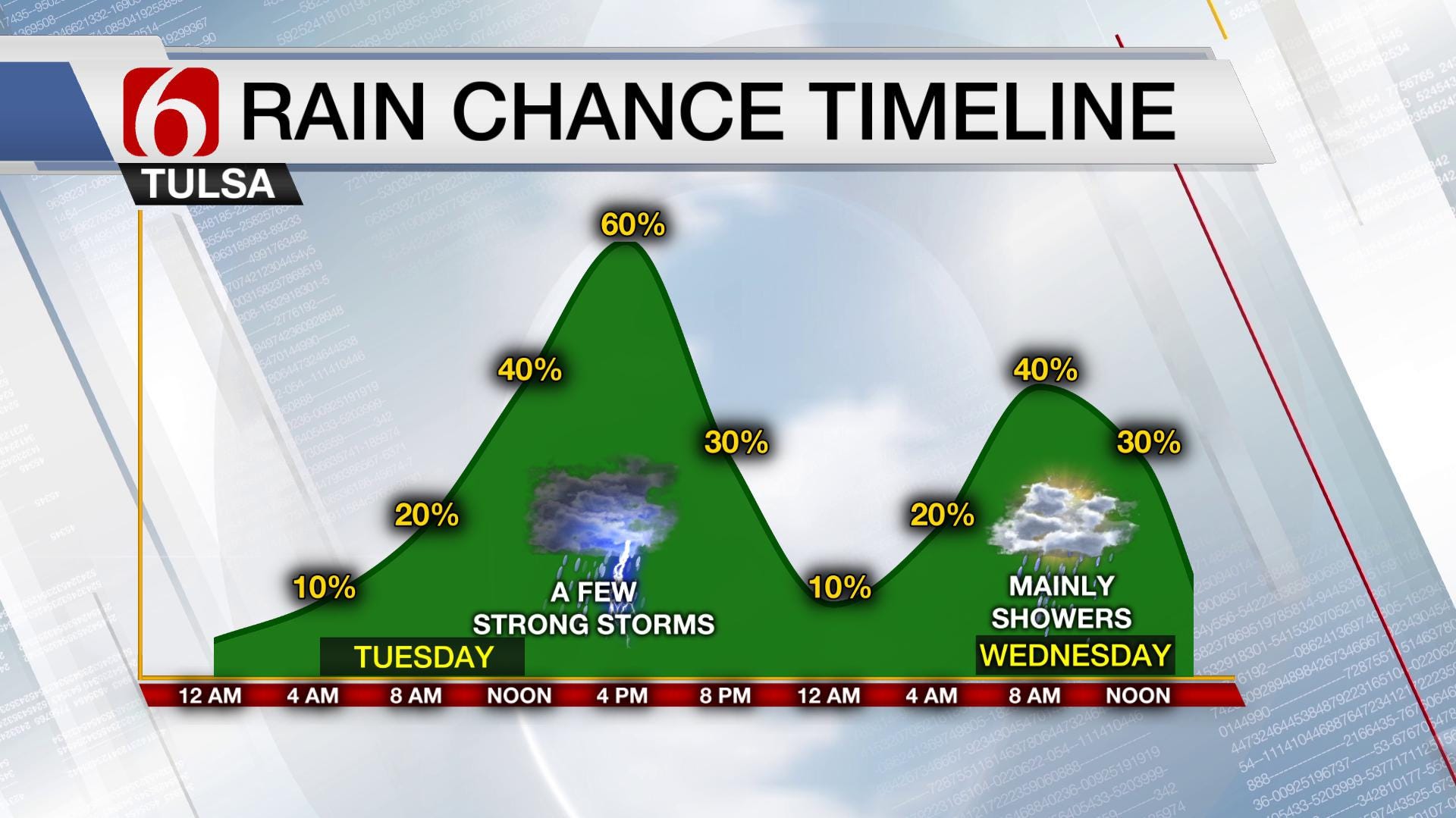
A slow-moving storm system is inching closer to Oklahoma. The first impacts will be felt by early Tuesday near the Oklahoma-Kansas line as remnant showers shift into the area from the west and northwest. A few sprinkles may make it to Tulsa before noon, but our better chance of rain comes midday into the afternoon hours. Daytime heating on Tuesday will interact with any boundaries that move into the area allowing robust thunderstorms to fire. So far, that seems to be in an area near or just north of I-44 as early as noon. Storms likely increase in intensity and coverage as they expand eastward with time. High wind gusts are the biggest threat in addition to localized flash flooding. These storms will make their way into southeast Oklahoma by early evening as they begin to dissipate. That’s Round 1.
[img]
Round 2 begins Wednesday morning. As the main front shifts slow southward through Green Country on Wednesday, so will the focus for rainfall. It appears the next wave of energy will bring rain and embedded storms for areas along and south of Highway 412. That puts Tulsa at the fringe of heavier rain potential, but the cloud cover at the very least should keep those temperatures below 90°. Above is the rainfall timeline through midweek for the Tulsa area.
Beyond Wednesday, rain chances will dwindle except for far southern parts of the state. That’s because the washed out frontal boundary will keep the focus for showers and storms near its location around the Red River. However, hot air won’t rush back in behind the system. At the worst, it’ll be muggy with near-normal readings into the weekend. In that air mass, a few pop-up thundershowers can’t be ruled out. Between now and the end of the week however, some of us will end up with some nice rain totals, most of which will fall between Tuesday and Wednesday.
[img]
Our unsettled pattern doesn’t end here however. A piece of that upper-level energy from this week breaks off, drifts west and hangs out a few days before shifting back over Oklahoma early next week. This will bring a renewed chance of rain and corresponding drop in temperatures as a result. This means through mid-August, no more triple-digit days are in the forecast! While there’s almost no chance we’ll make up our 7”+ rainfall deficit in Tulsa in this wetter pattern, the hope is that we’ll dent or at least stall the worsening drought in Oklahoma. This should also keep Green Country, GREEN, a bit longer!
[img]
If you just can’t wait for cooler weather, we’re not as far from it as you might think as shown in our countdown below!
[img]
Be sure to follow me on Twitter: @GroganontheGO and on my Facebook Page for more weather updates!

Get The Daily Update!
Be among the first to get breaking news, weather, and general news updates from News on 6 delivered right to your inbox!
More Like This
August 6th, 2018

April 15th, 2024

April 12th, 2024

March 14th, 2024
Top Headlines

April 24th, 2024

April 24th, 2024


April 24th, 2024
