Sunshine Returns Today: Alan Crone's Weather Blog
The system that brought the cold air and freezing drizzle to northern OK yesterday afternoon and evening will keep us in the chilly air today.Wednesday, January 23rd 2019, 8:48 am
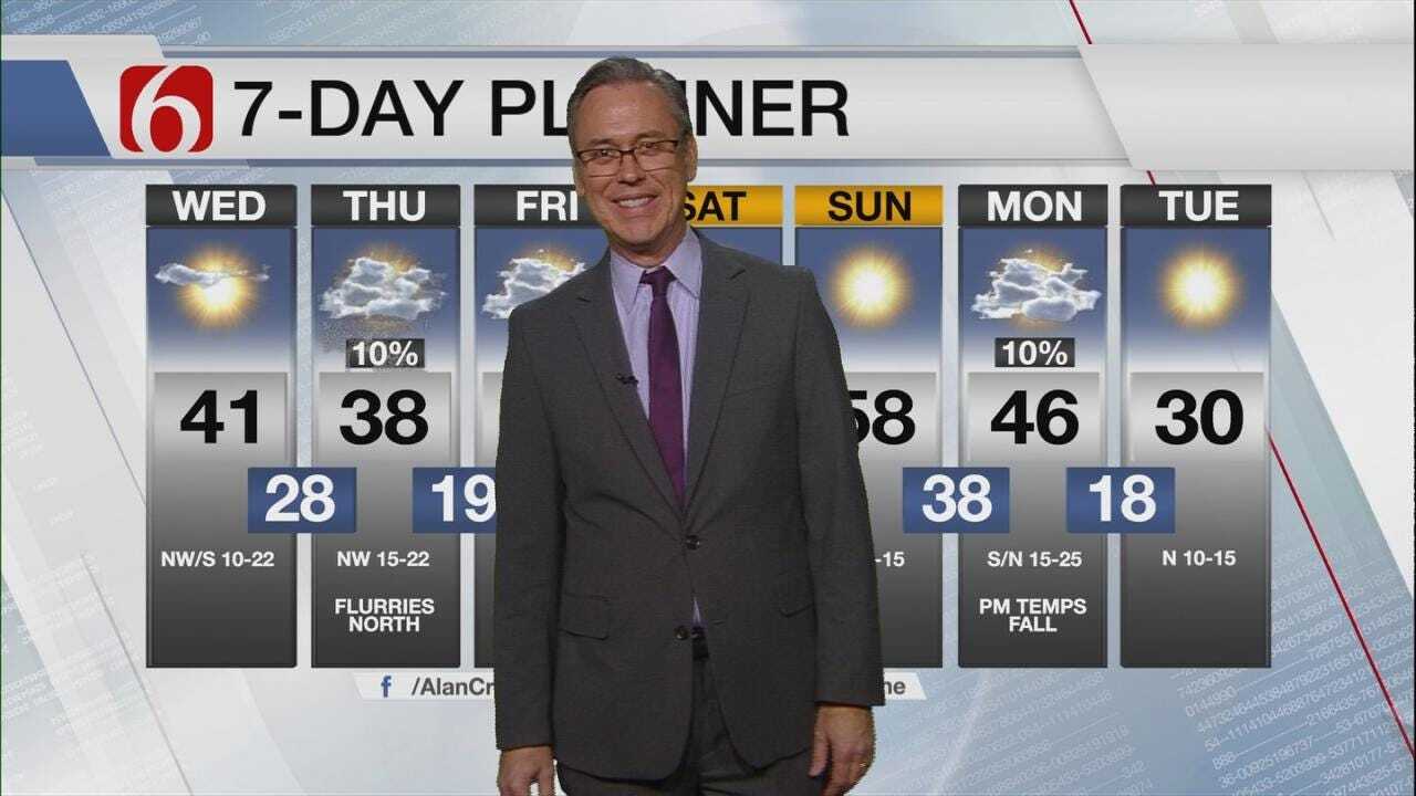
The system that brought the cold air and freezing drizzle to northern OK yesterday afternoon and evening will keep us in the chilly air today. Several additional fronts will move across the area over the next seven days. In between we’ll also experience a mild warm-up for the weekend with Sunday featuring the warmest weather.
Temps this morning will start well into the lower to mid-20s with a gusty northwest wind creating wind chills in the teens. Highs this afternoon will range from the upper 30s to lower 40s with full sunshine and gradually lowering wind speeds. The warmest readings into the mid-40s will be possible across the I-35 corridor.
A few slick spots may continue to be found this morning across eastern OK, more so across the far eastern sections. Gusty north winds have helped to dry most roadways in the metro overnight. Regardless, use some caution early this morning while driving the bridges and overpasses. Play it safe.

The upper air flow will remain from the northwest for the next few days with several upper level waves traversing the state. The next upper level system, currently around Alberta Canada will quickly dive southeast and approach the plains late tonight into early Thursday morning. The associated surface front will cross the state early to midday Thursday with a slight chance of a few showers or even snow flurries across the northern third of Oklahoma. This chance remains low. The GFS paints a small disturbance brushing us Friday midday with a few flurries north, but again, this chance will remain very low.
This morning's data supports a return to southwesterly surface winds sometime Friday that should hold through most of the weekend. This means the cold and chilly air mass currently in place across eastern OK will move eastward, out of the region this weekend, with relatively warmer weather returning.
Saturdays highs should be in the upper 40s or even lower 50s with Sunday potentially reaching the mid to upper 50s. But the party comes to an end late Sunday night and Monday morning as another strong surge of cold air moves southward. It appears a rather pure blend of arctic air will break loose and travel southward approaching the state Monday morning to midday.
We may reach the 40s Monday but as the front powerhouses through the area, strong north winds will bring the cold air and falling temperatures. Tuesday morning projections take us back down into the mid-teens with highs in the lower 30s Tuesday afternoon. The precipitation potential with this surge of cold air currently appears very low. But I would anticipate some changes will be possible as we draw closer to this frontal passage. For now, only low chances will remain.
Thanks for reading the Wednesday morning weather discussion and blog,
Have a good day.

Get The Daily Update!
Be among the first to get breaking news, weather, and general news updates from News on 6 delivered right to your inbox!
More Like This
January 23rd, 2019

April 15th, 2024

April 12th, 2024

March 14th, 2024
Top Headlines


April 19th, 2024


