Severe Weather Returns Monday
Cool and calm weather is underway ahead of a powerful storm system moving across the state later today, tonight and early Tuesday bringing thunderstorm chances back into the state including severe weather threats.Monday, May 20th 2019, 7:36 am


Cool and calm weather is underway this morning ahead of a powerful storm system that will move across part of the state later today, tonight and early Tuesday morning bringing thunderstorm chances back into the state including severe weather threats, some significant, Monday and part of Tuesday.
The upper air pattern will require us to keep a slight mention of additional showers and storms for small portions of the area Wednesday and then again Friday and Saturday to our northwest with another system nearing. But a ridge of high pressure located to our east may keep most of this activity to our northwest.
A strong short wave is positioned across the western U.S and will be ejecting into the central plains today through Tuesday morning. Very strong winds aloft are expected with this system moving from the southwest to northeast across the plains with wind speeds between 70 to 80 knots. This will cause a rapid drop in air pressure across part of New Mexico into Colorado where a surface area of low pressure is developing this morning.
As this low moves eastward, the warm front located to our south will move northwest into the central part of the state by midday to afternoon bringing higher dew points into western OK and also surging northward closer to the Tulsa metro. Elevated hail storms are already underway across the high plains of Texas this morning, closer to the main upper level support, but eastern OK remains dry at this hour.
By noon to early afternoon, this warm front should be located across most of central OK arching northeast along or northwest of the I-44 corridor region. A few showers and storms will attempt to develop on the cool side of this boundary by midday. Most of these storms would be slightly removed from the actual boundary and would be capable of large hail. Locations south of the warm front will be increasingly unstable but with very few convective storms attempting to form during the early portion of Monday midday.
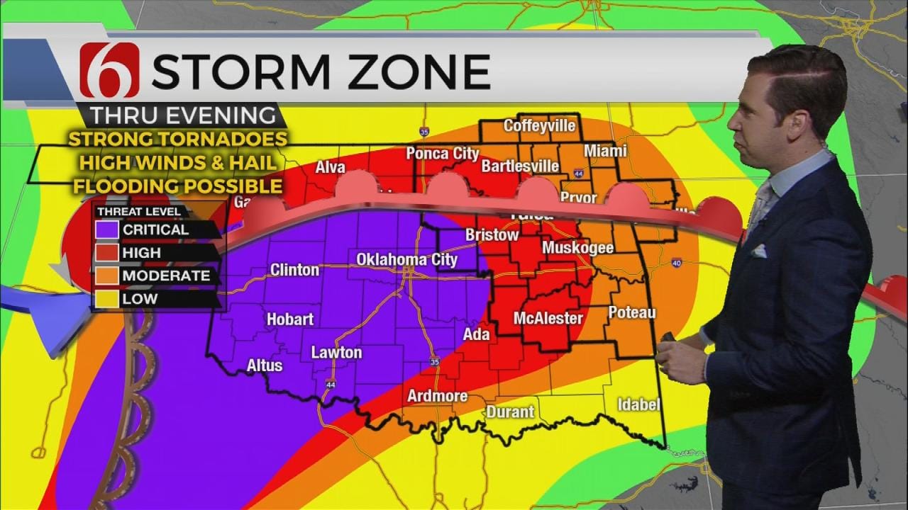
Further into western Oklahoma, thunder storms will begin developing along the intersection of the dry line, surface low and warm front and will spread northeast with time. These storms are expected to be mostly discrete super-cell storms by afternoon. Severe weather overlays support deep layer shear and surging moisture into this region that may produce a few long track and strong tornadoes with some of these storms as they become mature by late afternoon and evening. Some of these storms may move along the I-44 corridor Monday evening. More southward, across east-central to far southeastern Oklahoma, the atmosphere will be very unstable but with little in the way of significant forcing moving across this region until later this evening. None the less, if any thunderstorms develop in this warm sector, they would also be super-cells capable of significant severe output.
We may see a small, brief lull around 3 a.m. to 6 a.m. before a squall line develops and moves across central to eastern OK Tuesday morning through early afternoon with damaging winds and a few quick tornado spin-ups on the leading edge, similar to this past Saturday mornings system. This linear formation should clear far eastern OK into western Arkansas by midday to early afternoon with clearing sky and improving weather Tuesday afternoon and evening.

The severe weather risk assessment from the Storm Prediction center indicates the potential for a severe weather outbreak for part of southwestern to north-central Oklahoma that may spread into northeastern sections of the state late Monday afternoon into the late evening. Another major concern is the likelihood for heavy rainfall across part of the upper Arkansas basin. Flood watches will be underway today through Tuesday night across a large portion of the area. Recent heavy rainfall and saturated grounds may lead to some flash flooding later this evening through Thursday morning. Additionally, river and stream levels may also rise later this week with some area lakes seeing increasing levels in a few days.
As always with these systems, minor changes to certain parameters can mean big changes to exact locations and timing. We’ll encourage you to remain aware of your weather surroundings later this afternoon into Tuesday.
Thanks for reading the Monday morning weather discussion and blog.

Get The Daily Update!
Be among the first to get breaking news, weather, and general news updates from News on 6 delivered right to your inbox!
More Like This

May 20th, 2019

April 15th, 2024

April 12th, 2024

March 14th, 2024
Top Headlines

April 18th, 2024

April 18th, 2024

April 18th, 2024

