Eastern Oklahoma Under Tornado Watch
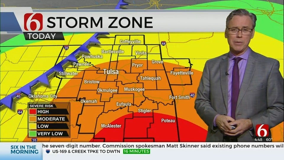
Our first concern is severe weather threats today, including heavy rainfall, flash flooding and river flooding, damaging winds, hail and even a tornado warning or two.Friday, January 10th 2020, 6:31 am

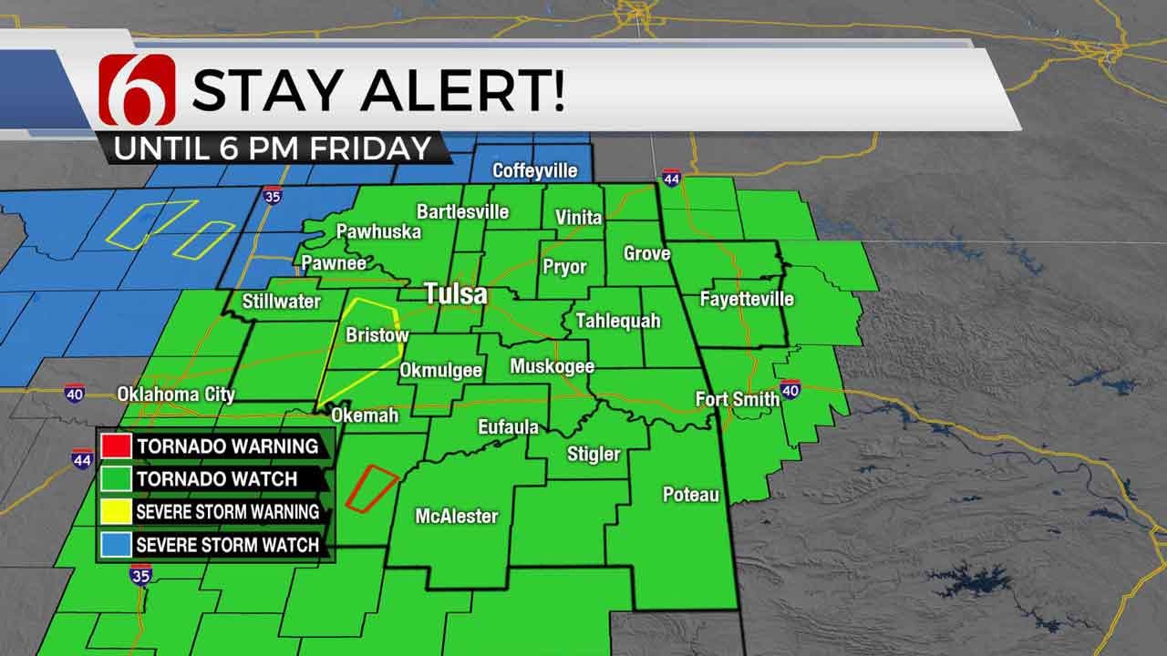
A tornado watch has been issued for all of northeastern Oklahoma until 6 p.m. There may be an extension of the watch for later this evening as well. Conditions are favorable for the development of severe weather as storm systems move through.
News On 6 Oklahoma Weather Experts will continue to keep you informed on air and online.
Our first concern is severe weather threats today, including heavy rainfall, flash flooding and river flooding, damaging winds, hail and even a tornado warning or two. Secondly, the potential for impactful winter weather Saturday morning through midday remains across northeastern OK with some accumulating wintry precipitation possible.
A very potent upper level trough is approaching the plains this morning with strong jet streak winds from 80 to 100 knots a possibility. Low level moisture has rapidly increased over the last 36 hours with dew points nearing the upper 50s and lower 60s across eastern OK this morning. A strong cold front will develop and move across northwestern OK early this morning and will be approaching the northeastern Ok vicinity by early afternoon. A surface low pressure area may also form along the Red River Valley and track eastward through the early afternoon period.

All these features support the chances today for scattered storms this morning through midday before a line of thunderstorm activity develops by afternoon and moves eastward. A few storms may be nearing the metro between 11am and 1pm that could produce hail and gusty winds, but the amount of instability remains in question for the early periods. Regardless, around midday to early afternoon, additional storms will begin forming ahead of the front and could become severe with all modes of severe weather possible. Around the 4pm to 6pm hours, the cold front will be moving east-southeast, and storms will become more numerous along the front developing a line of strong to severe storms capable of damaging winds, very heavy rainfall and possibly a few embedded tornadoes. This line of storm activity will then exit southeastern OK around the 8pm to 10pm hours with additional severe storms continuing across northeast Texas into the ArkLaTex where significant severe weather will occur.

Later tonight into Saturday morning, much colder air will quickly arrive behind the surface front with a small break in precipitation overnight. As the main upper level trough nears the central to eastern OK region, additional precipitation will attempt to develop somewhere across central to northeastern OK and undergo transitions to some wintry mix and eventually snow. The global models remain highly optimistic with outputs reaching winter storm warning criteria while some of the higher resolution runs are more in line with winter weather advisory level snows. At this point, our forecast continues holding with a potential of 1 to 3 inches near the metro with higher amounts to the northwest of the I-44 corridor. There will be a small window for some freezing rain or sleet early Saturday before transitioning to snow. The longer this window occurs, the lower the snow accumulations. Locations along and south of I-40 continue to have some snow chances but will be lower chances compared to the north. Those with travel plans Saturday morning should remain aware of the forecast and be prepared for some impacts on roadways and bridges. Additional changes to the wintry precipitation forecast are still possible.
The system will exit the state Saturday early afternoon with cold weather remaining Saturday night into Sunday as sunshine returns Sunday afternoon with highs in the mid to upper 40s. Pleasant conditions will quickly arrive early next week with more sunshine and highs in the upper 50s to lower 60s before arctic air arrives Wednesday and remains across the state for the 2nd half of next week. There may be another upper level system nearing the state by the end of the week.

Please remain aware of your weather surroundings today and tomorrow. Our main concern today is for the severe weather potential.
Thanks for reading the Friday morning weather discussion and blog.
Have a super great day!
Alan Crone

Get The Daily Update!
Be among the first to get breaking news, weather, and general news updates from News on 6 delivered right to your inbox!
More Like This

January 10th, 2020

November 30th, 2022

November 1st, 2022

August 26th, 2022
Top Headlines

April 23rd, 2024

April 23rd, 2024


April 23rd, 2024
