Winter Weather Advisory Issued For Northeastern Oklahoma Tonight
A winter weather advisory has been issued for much of eastern Oklahoma for midnight to 3 p.m. Wednesday.Tuesday, January 21st 2020, 6:35 am

Our next upper level system is currently west of the state but will quickly arriving later tonight into Wednesday morning with increasing rain to snow to wintry mix chances for the area.
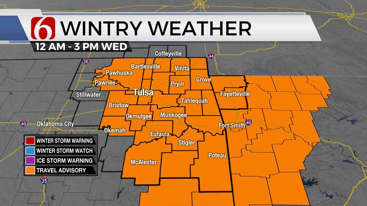
The National Weather Service has issued a Winter Weather Advisory that will be in effect from midnight tonight to 3 p.m. Wednesday for much of northeastern Oklahoma. Counties include Tulsa, Creek, Haskell, Latimer, McIntosh, Muskogee, Nowata, Okmulgee, Osage, Pawnee, Pittsburg, Rogers, Wagoner and Washington.
Temperatures later tonight will be dropping into the lower or mid-30s before remaining constant through the morning hours as some precipitation begins impacting the area. Our surface temperatures should be slightly above freezing, but the overall thermal profile will continue to support some wintry mix, including rain to snow and then back to rain from 1 a.m. Wednesday morning into the early hours of the commute.
We are not expecting any major impactful issues with this system, but this system is tricky regarding the exact temperature profile. As all winter systems go across eastern OK, it doesn’t take much to generate some travel issues.
Very cold weather is common Tuesday morning, January 21, with many locations in the teens and lower 20s across northeastern OK along with clear sky and mostly light winds. Even a gentle 4 to 7 mph wind will drop windchills into the single digits. We’re in the running for mostly sunny conditions early today before clouds arrive later this morning into the afternoon from the west in advance of our next system. High today will be warmer than yesterday compared to the metro, with afternoon readings in the lower to mid-40s. Southeast winds will return later this morning and continue into the evening hours.

Our next upper level system is currently west of the state but will quickly arriving later tonight into Wednesday morning with increasing rain to snow to wintry mix chances for the area. Temperatures later tonight will be dropping into the lower or mid 30s before remaining constant through the morning hours as some precipitation begins impacting the area. Our surface temperatures should be slightly above freezing but the overall thermal profile will continue to support some wintry mix, including rain to snow and then back to rain from 1am Wednesday morning into the early hours of the commute. We are not expecting any major impactful issues with this system, but this system is tricky regarding the exact temperature profile. As all winter systems go across eastern OK, it doesn’t take much to generate some travel issues. As of this morning, no advisories are posted for this event.

Our main window for any wintry impacts will be from Wednesday 2am to about 9am. Additional precipitation will continue after this window but would be mostly in the form of light rain showers or some drizzle. If the temperature profile is even 2 degrees colder than anticipated pre-dawn Wednesday, some accumulation of snow would be possible. Temperatures through Wednesday will slowly climb into the upper 30s to lower 40s before also remaining steady Wednesday night into Thursday morning as our next upper level system quickly drops through the pacific northwest and into the plains. This will force a new surface low formation across either southeastern Colorado or southwestern Kansas with gusty southeast winds both Wednesday and Thursday across the central and eastern sections of the state. Higher dewpoints (and low-level moisture) will be increasing during these periods along with surface temps climbing into the upper 40s near 50 by Thursday afternoon or early evening. Additional showers will be likely late Wednesday evening into early Thursday before the main upper level system quickly exits the central plains taking our system out of the state. As it stands now, we may be mostly rain free Thursday after some early Thursday morning showers quickly leave. Based on the current projection for the upper level system, any wraparound snow will remain to our northeast, across part of eastern Kansas or eastern Missouri with the system leaving Friday morning. If the low tracks more southward than anticipated, some wrap around moisture would be possible across far northern OK and southeastern Kansas. At this juncture, we’re keeping a very low placeholder mention for some flurries Friday morning before clearing skies bring pleasant conditions across the state into the weekend with morning lows in the 20s and 30s and afternoon highs Saturday in the lower 50s and Sunday into the upper 50s or even some lower 60s.
We’re encouraging you to remain aware of this incoming system for early Wednesday morning as some travel issues may be possible. Some additional changes will still be possible.
Thanks for reading the Tuesday morning weather discussion and blog.
Have a super great day!
Alan Crone

Get The Daily Update!
Be among the first to get breaking news, weather, and general news updates from News on 6 delivered right to your inbox!
More Like This

January 21st, 2020

November 30th, 2022

November 1st, 2022

August 26th, 2022
Top Headlines

April 23rd, 2024

April 23rd, 2024


April 23rd, 2024
