Winter Is Coming To Northeastern Oklahoma; Snow Likely
A strong winter system will be nearing the state over the next 24 to 36 hours bringing much colder weather along with accumulating snow chances across portions of the regionTuesday, February 4th 2020, 7:49 am
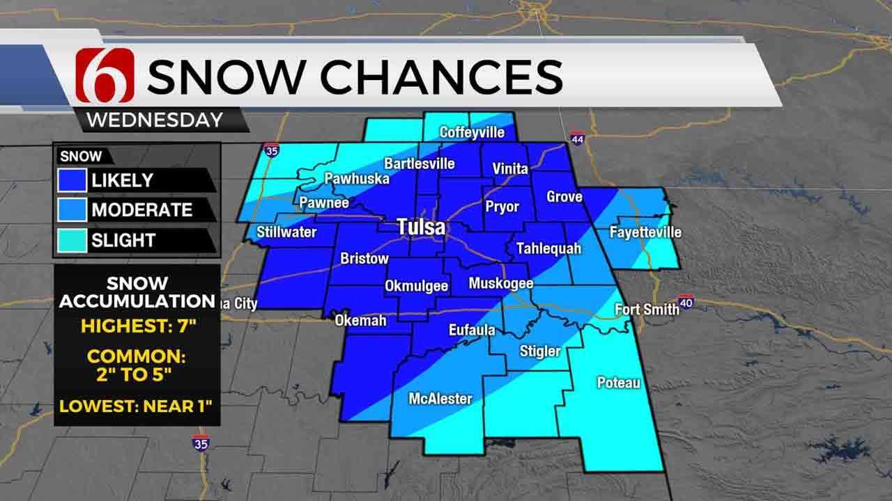
A strong winter system will be nearing the state over the next 24 to 36 hours bringing much colder weather along with accumulating snow chances across portions of the region. A Winter storm watch remains for central, southwestern, southcentral and northeastern OK tonight through Wednesday. Winter storm warnings may be forthcoming later this afternoon or evening for portions of the area. Accumulating snow remains likely for part of the area, including the Tulsa metro, for Wednesday. The cold weather will remain through Thursday before moderating some Friday into part of the weekend. Additional cold weather is expected next week.

After yesterdays upper 60s and lower 70s, colder weather is moving across the state this morning and will soon move into southeastern Ok during the next few hours before staling along or near the Kiamichi or Jack Fork Mountains. Some locations across southeastern OK remain in the 50s this morning but will drop quickly through morning. Most locations near Tulsa are currently in the upper 30s and lower 40s but will also level off into the lower 30s by the afternoon with stout north winds and wind chills in the 20s. A stark difference from the 70s we experienced Sunday and Monday.

Showers or storms will remain possible for the next few hours across east-central to extreme southeastern OK before moving into Arkansas. While severe weather is not expected this morning, a few cells may produce some lightning and moderate to heavy rainfall. We do have a slight chance of showers in the metro for the next few hours. Drizzle may also develop later today along the state line into southeastern Kansas where temps will be dropping to near freezing soon. A winter weather ( travel advisory) will be in effect for southeastern Kansas today due to the potential of freezing drizzle or light sow.

Two disturbances in the upper air flow will basically provide the lifting for our incoming system providing strong lift that will move across the Red River into southwestern OK later tonight and into northeastern OK Wednesday morning to midday. The exact trajectory of a plume of moisture combined with this system will produce some impactful snowfall across the area, including some winter storm warning criteria snow ( 4 to 6 inches) along this zone. Currently, this zone will be located from southwestern OK to the Arbuckles and slightly southeast of the OKC metro and near the I-44 corridor. Locations along and south of the I-40 corridor, across part of southeastern OK may also be in-between these two areas, but some accumulation is likely. There may also be some freezing rain or sleet mix across far southeastern OK Wednesday morning to midday which could complicate matters even more regarding amounts of winter weather accumulations in these areas.
We continue to have different data from the various models regarding the output of this system. It seems this is the new norm the past two winters. Even 24 hours out from an event, there will be some uncertainty regarding where the heaviest band of snow will set-up Wednesday.
Once this system exits the area Wednesday afternoon or early evening, cold weather will remain Thursday but should moderate into the weekend, despite another weaker upper level trough that will pass the area Friday into Saturday. At this point, we are including a low chance of a shower or snow flurries for late Friday night into pre-dawn Saturday.
In summary, we’ll encourage you to remain aware of the weather for the next 48 hours. Some accumulating snow remains, including the Tulsa metro, Wednesday.
Thanks for reading the Tuesday morning weather discussion and blog.
Have a super great day!
Alan Crone

Get The Daily Update!
Be among the first to get breaking news, weather, and general news updates from News on 6 delivered right to your inbox!
More Like This
February 4th, 2020

November 30th, 2022

November 1st, 2022

August 26th, 2022
Top Headlines


April 19th, 2024


