Winter Storm Warning Remains For Most Of Northeastern Oklahoma
A mixed bag of precipitation is likely very early this morning before becoming all snow near the metro. Accumulations are likely. Highs today will be near freezing with north winds at 10 to 25 mph creating wind chills in the lower 20s.Wednesday, February 5th 2020, 4:47 am
A mixed bag of precipitation is likely very early Wednesday morning before becoming all snow near the metro. Accumulations are likely. Highs today will be near freezing with north winds at 10 to 25 mph creating wind chills in the lower 20s. Due to the potential impacts from this system, the National Weather Service continues with Winter Storm Warnings for a large portion of Northeastern OK. These warnings also exist to our southwest, from the OKC metro into southwestern Oklahoma. A travel advisory is posted for southeastern OK for this event.
The thermal structure of the atmosphere should support a sleet to snow transition through the early hours of this event near the metro, with locations to our northwest mostly snow. Locations near McAlester eastward may receive more icing than snow that could extend eastward along highway 270 into western Arkansas, where the hilltops of the mountain could also support ice. Most of southeastern OK is not in a favored position for snow with this event.
Locations along both sides of the I-44 corridor will eventually be, what should be, the favored locations for snow. Our forecasting issues this morning centers upon a small area of warm air off a few thousand feet above the surface. This layer should promote the growth of sleet at the surface during the very beginning phase as moisture arrives across northeastern OK. The longer this sleet phase last will cut down on the amount of snow accumulation totals. So, our question: When will it transition from sleet to snow? The bufkit data suggests about 1 to 2 hours of sleet-snow mix before all snow around the metro, with locations northwest of the I-44 area already cold enough from the column down for all snow. Basically, we’re on for the ride at this point.
Another item of interest would be thunder sleet or thundersnow. Yep, it’s possible with this system. And if it does occur, a localized area could see a quick burst of very heavy snowfall.
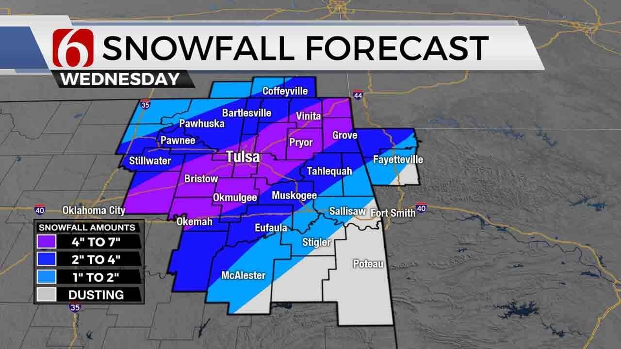
Bottom line: the winter storm warning remains along the I-44 corridor today into tonight for some impactful accumulations of sleet and snow, anywhere from 4 to 6 inches along the I-44 corridor, with some locally higher totals possible. More sleet means lower snow totals. Locations south and east of the metro, currently in a winter weather advisory, will have much lower accumulations, from a dusting to near 2 inches. Extreme southeastern OK will have rain. There remains a possibility that ice will become a concern near McAlester eastward during this event. We’ll track two distinct waves, the first arriving this morning through mid-day and the 2nd arriving late this afternoon into early evening. The heaviest precipitation is expected with the first wave and lighter amounts for the 2nd.
Temperatures Thursday morning should be in the upper teens over the snow-sleet pack. Some patchy fog is possible with sunshine and highs in the mid to upper 30s by afternoon.
Friday morning lows will be in the 30s with afternoon highs nearing the upper 40s as a fast and weak upper level system brushes the state late evening into early Saturday morning bringing a small chance of showers or flurries. This will be minor. Saturday morning lows will be in the upper 20s or lower 30s with daytime highs nearing the lower 50s. Sunday we should rebound near 60 along with gusty south winds before our next system arrives Monday with a chance for showers and storms followed by another cold snap early next week.
Thanks for reading the Wednesday morning weather discussion and blog.
Be safe and have a great day!
Alan Crone

Get The Daily Update!
Be among the first to get breaking news, weather, and general news updates from News on 6 delivered right to your inbox!
More Like This
February 5th, 2020

November 30th, 2022

November 1st, 2022

August 26th, 2022
Top Headlines

April 25th, 2024