September Heat Wave Building
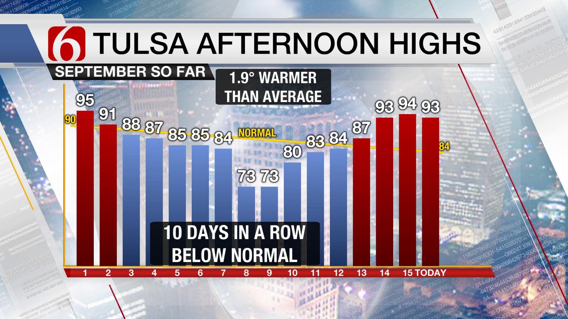
Not all that long ago, it truly felt like fall was upon us. For ten days in a row, we had below-normal high temperatures. Two of those days, as you see below, only warmed to a mild 73°. That cool air was a product of a prolonged cloudy and wet spell versus a true autumn cold front. Usually we have one sweeping in from the north by now, but so far, summer still has a firm grip. [img] While our temperatures have heated up, so did the Tropics. At one point, there were four named ...Sunday, September 16th 2018, 9:44 pm
Not all that long ago, it truly felt like fall was upon us. For ten days in a row, we had below-normal high temperatures. Two of those days, as you see below, only warmed to a mild 73°. That cool air was a product of a prolonged cloudy and wet spell versus a true autumn cold front. Usually we have one sweeping in from the north by now, but so far, summer still has a firm grip.
[img]
While our temperatures have heated up, so did the Tropics. At one point, there were four named storms alone in the Atlantic. Florence has moved inland to the East Coast but is still creating devastating effects across the Carolinas due to FEET of rainfall. While hurricanes at that latitude on the East Coast usually catch the jet stream and get steered quickly northward, Florence did not follow suit. Florence’s excruciatingly slow trek westward over the past several days has been a result of an unseasonably strong ridge in the jet stream, the same ridging that is bringing us our late season heat wave.
[img]
As the map above shows, that jet stream is displaced well to the north, more of what is typical in July and August. There is cold air to be found, but it remains bottled up across Canada where snow has been falling on the prairies of Alberta already. Until that jet stream buckles southward and sends a chunk of colder air our way by way of a cold front, we will continue to have some bonus days of summer. If you kept your pool open, this is your lucky season!
The ridging will slowly grow stronger through midweek over Oklahoma, bringing our temperatures over 10° above normal. We still have a fairly moist air mass in place. This will result in a heat index each afternoon creeping up to the century mark through at least Thursday. Our fall preview earlier this month seems to rapidly be falling out of view. It’s back to the Dog Days instead.
There is a little relief in sight! A trough in the jet stream will slide quickly eastward from the Rockies late this week, sending a cold front our direction. Here’s the catch: there’s a good chance it won’t even reach Oklahoma. Regardless of how far the cold front sags southward, it should still bring us a few days of cloud cover and some rain nearby. Areas just north of Tulsa would especially welcome this where a remnant area of the drought is found. Fittingly, this brief cool-down and chance of rain corresponds to the first day of fall on Saturday! Instead of 90s for highs, we’ll see 80s as it looks right now. Below is our temperature departure trend for the week ahead.
[img]
In the long range, September continues to look toasty. The jet stream continues to keep the storm track north of us and the doldrums of summer may carry on up to another week. The Outlook for the remainder of the month is warmer than normal not just for us, but for most of the Lower 48. The closer we get to October, the harder it is for the atmosphere to hold onto this summer pattern as cold air continues to build at the North Pole and find ways southward. About 10-12 days from now, there are signs of a stronger storm system that could bring that first significant cool-down of the new season. While the timing is far from nailed down, we’re likely to see some shift in the pattern then. If it doesn’t by the start of October, we’ll be hitting record high territory! So if you like summer, soak up the rest of September.
[img]
For more, be sure to follow me on Twitter: @GroganontheGO and on my Facebook Page!
More Like This
September 16th, 2018
September 29th, 2024
September 17th, 2024
Top Headlines
December 11th, 2024
December 11th, 2024
December 11th, 2024
December 11th, 2024


