

Unusual August Weather Continues For Eastern Oklahoma
<p>A few showers and storms may again be possible this morning through midday, mostly across southern or east central Oklahoma, as a weak boundary to our south lifts northward for the next few hours. </p>Tuesday, August 15th 2017, 4:07 am


A few showers and storms may again be possible this morning through midday, mostly across southern or east central Oklahoma, as a weak boundary to our south lifts northward for the next few hours. Most storm activity has been across far southeastern Oklahoma and part of northwestern Arkansas but I’m inclined to keep a slight mention even for northeastern Oklahoma.
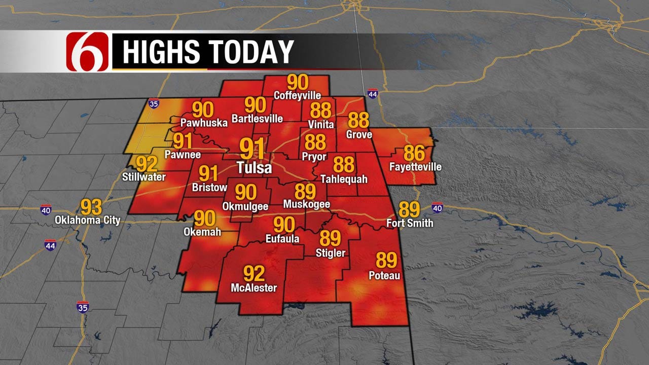
We may also see some stratus or even fog developing across part of eastern Oklahoma early this morning. Other showers and storms will move into southwestern Oklahoma for the next few hours. Highs will be back around 90 today with our heat index value nearing 100. There may be a few isolated storms that could develop later this afternoon near or northwest of the metro but the odds will continue to be rather low.
The pattern, however, will remain quite active through the week with plenty of chances for showers and storms including at least one and possibly two separate storm complexes impacting part of the area.
The upper air flow will still be favorable for allowing active weather to impact the area for at least the next week and possibly into the weekend before mid-level heights rise (ridging begins) and the storm chances finally dwindle as the typical summer heat has a chance to return for a few days early next week. The issues will involve the specific timing of the specific waves. Frankly the timing in the data has not been consistent regarding the potential MCS possibilities and my confidence in this forecast package is fairly [CA1] low. I had to make a pretty significant change for the Wednesday night and Thursday morning forecast compared to yesterday at this hour as there seems to be a better chance for Wednesday evening into pre-dawn Thursday compared to yesterday morning’s data. It still appears there may be another MCS nearing late Thursday night into Friday morning across part of the area, and possibly even Saturday morning. Again, the confidence is low and additional changes seem likely for the extended portion of the forecast. A strange and challenging August pattern continues.
Temps today will be in the lower 90s along with heat index values nearing 100.
Thanks for reading the Tuesday morning weather discussion and blog.

Get The Daily Update!
Be among the first to get breaking news, weather, and general news updates from News on 6 delivered right to your inbox!
More Like This

August 15th, 2017

September 29th, 2024

September 17th, 2024

Top Headlines
December 11th, 2024

December 11th, 2024

December 11th, 2024

December 11th, 2024