

At Peak Severe Weather Season, More Storms on the Way
We are enjoying a nice lull in the active weather here at the start of the week. Any quiet day in Green Country during peak severe weather season is not to be taken for granted. However, a multi-day storm event is likely later this week and severe weather is almost assuredly in the mix. A deep trough in the jet stream has formed over the western U.S. If you read my blogs enough, you probably kn...Monday, May 15th 2017, 6:41 pm


We are enjoying a nice lull in the active weather here at the start of the week. Any quiet day in Green Country during peak severe weather season is not to be taken for granted. However, a multi-day storm event is likely later this week and severe weather is almost assuredly in the mix.
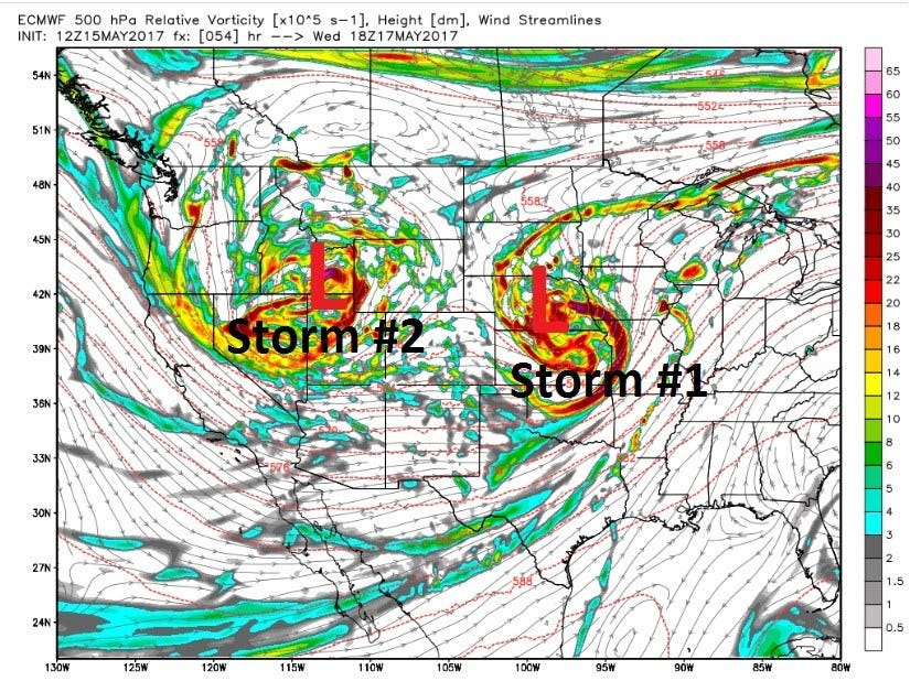
A deep trough in the jet stream has formed over the western U.S. If you read my blogs enough, you probably know that it’s a precursor to a stormy pattern here in Oklahoma. And, alas, that trough is allowing strong southerly flow at the surface. Moisture is returning and heat is building in advance of this two-part storm system shown below (valid Wednesday). The first part is already affecting the Panhandle region with storms forming along and ahead of a dry line. There is not yet enough energy to send those storms our direction, but by Tuesday night, our storm chances return.
[img]
Tuesday’s severe weather threat is highest west of I-35 where storms will form. That night, we get the leftovers. Any storms that make it to our side of the state will likely produce gusty winds and bring some risk of hail. Fortunately, tornadoes aren’t all that likely with this first wave. Showers and a few storms may linger into Wednesday before this potent wave lifts northeast, clearing us out for a short time. The risk of severe weather for Tuesday evening is shown below.
[img]
Into Thursday, a more substantial severe weather threat evolves. This appears to be a classic severe weather set-up with a surface low pressure in southwest Kansas, a dryline extending south of it and lots of wind shear, instability and moisture to go with it. This is the kind of day where tornadoes are possible, if not likely, in addition to hail and high winds. The initial threat will be west of Tulsa, but storms may arrive later that evening with a continued threat of strong to severe storms re-firing on Friday. The progression of this storm system is still in question as we head into the weekend. One of our main computer models, the GFS, is quick to send the cold front through the region on Saturday, effectively taking away the storm threat. However, the EURO model, arguably the most consistently accurate longer-range model suggests the frontal boundary stalls across our state until Sunday due to a much slower movement of the upper level low pressure. For those with weekend plans, know that Saturday will likely be wet and stormy for at least part if not most of the day. Any surface boundary that lingers in a strongly sheared and moist environment will likely cause heavy storms with flooding potential. That becomes the final main concern with this active pattern. Below are possible rain totals from the culmination of these couple storm systems.
[img]
It does appear we’ll see a drier, clearing trend by Sunday. Hopefully not the entire weekend will be a washout. Beyond our typical 7-day forecast time span, the jet stream pattern still appears active, in that will continue to send storm systems through the state. However, it doesn’t appear high end severe weather will be as likely as cooler air intrudes into the area. 8 to 14 days out into Memorial Day Weekend, a wetter, but cooler than normal pattern is expected. That means the mugginess of this week will give way to more comfortable air for some time next week.
Spring and severe weather season are racing by with several instances of tornadoes and storm damage in the area. Fortunately, we’ve avoided an all-out tornado outbreak. We’re not of the woods regarding that later this week, but we know this time of year has been much worse to us. The biggest issue to watch will be flooding into the weekend – it’s the biggest severe weather killer after all. Stay safe and enjoy this great spring weather while it’s here!
[img]
[img]
Be sure to follow me on Twitter: @GroganontheGO and like my Facebook Page for more weather updates!

Get The Daily Update!
Be among the first to get breaking news, weather, and general news updates from News on 6 delivered right to your inbox!
More Like This
May 15th, 2017

September 29th, 2024

September 17th, 2024

Top Headlines

December 13th, 2024

December 13th, 2024

December 13th, 2024

December 13th, 2024