

Rain Returns For Eastern Oklahoma This Weekend
<p>Today may be the best weather day of the week with afternoon highs moving into the mid to upper 60's across northeastern Oklahoma and lower 70's across southeastern sections. </p>Friday, March 31st 2017, 4:23 am


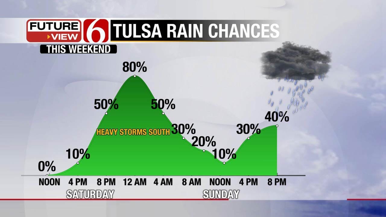
Today may be the best weather day of the week with afternoon highs moving into the mid to upper 60's across northeastern Oklahoma and lower 70's across southeastern sections. Northeast winds this morning will back from the southeast later this afternoon and tonight in response to our next storm system developing across the high plains of Texas into southeastern Colorado. This system will drop to the east and southeast this weekend bringing a mention for additional showers and storms Saturday evening into Sunday morning. Most of the severe weather threats Saturday will be confined to western sections of the state into central Oklahoma and the threats will remain rather low compared to the past few events. Sunday we’ll keep a mention for some precipitation near or south of the area as the surface low will be to the south of the Red River Valley. The next upper level system will quickly approach the area Tuesday into Wednesday with only a low mention for a few showers or storms followed by pleasant weather for the middle to end of next week.
The upper air pattern remains quite active with the latest in a series of western U.S. troughs ejecting near the state over the next 24 hours. As this upper feature nears the area a surface low will develop either in southeastern Colorado or the high plains of Texas and move east and eventually southeast Saturday. The upper air trough is expected to remain rather progressive and should remain open as it passes the State Sunday into Monday to our south and east. We continue to have some differences in the data regarding the evolution of the system but data this morning is closer to a consensus. We’ll have a high chance of showers and storms Saturday night into early Sunday morning, and then a moderate chance late Sunday night into Monday morning. This would place northeastern Oklahoma on the top side (cool side) of the system by Sunday.
Our afternoon highs will move into the upper 60's and lower 70's today along with northeast winds early and southeast winds late around 10 mph. We should have some sunshine near and south of the metro with a few clouds to the north and northeast.
Saturday morning starts with lows in the upper 40's and lower 50's. Daytime highs will be in the mid to upper 70's with increasing clouds and a chance for storms late Saturday afternoon and evening. Southeast winds will be likely at 15 to 25 mph.
Stay Connected With The News On 6
Sunday morning temps will be near 50 with highs in the upper 60's along with northeast winds, mostly cloudy sky, and a chance for showers or storms early Sunday morning. Sunday midday to afternoon should be dry with partly cloudy sky. Late Sunday night into Monday morning, we’ll need a slight chance for showers and storms in the forecast for northeastern Oklahoma with higher probabilities for southeastern Oklahoma. Monday morning lows will be in the upper 40's near 50. Highs will be in the mid to upper 60's.
Tuesday southeast winds will return with highs in the upper 70's with a slight chance of showers and storms in the forecast. Wednesday features lows in the upper 40's and highs in the upper 50's along with northwest winds.
Thanks for reading the Friday morning weather discussion and blog.
Have a super great day.
Alan Crone

Get The Daily Update!
Be among the first to get breaking news, weather, and general news updates from News on 6 delivered right to your inbox!
More Like This
March 31st, 2017

September 29th, 2024

September 17th, 2024

Top Headlines

December 12th, 2024

December 12th, 2024

December 12th, 2024
December 12th, 2024