

October Heat Wave Setting Records
<p>It’s not unusual to hit 90° at the beginning of October in Tulsa, but when we enter the second half of the month, climatology clear shows temperatures take a fairly steep decline towards the chill of winter. That’s why a 92° high on Monday and 100° temperatures on Sunday in our Panhandle are clearly moving us into record territory. We already set a Record Warm Low in Tulsa and McAlester and Sunday and will likely do the same on Monday morning as well.</p>Sunday, October 16th 2016, 11:29 pm


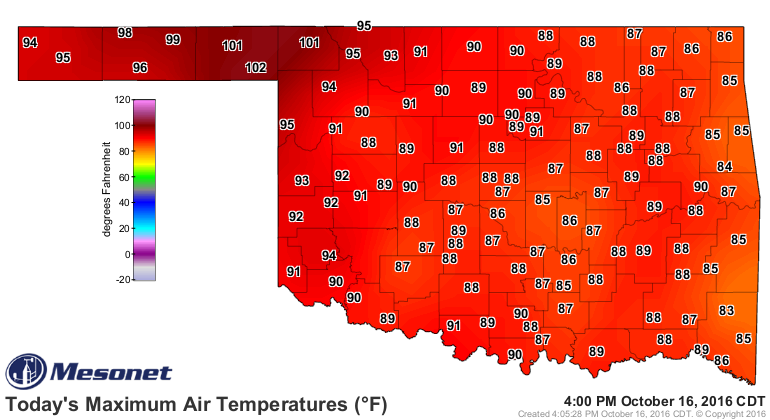
It’s not unusual to hit 90° at the beginning of October in Tulsa, but when we enter the second half of the month, climatology clear shows temperatures take a fairly steep decline towards the chill of winter. That’s why a 92° high on Monday and 100° temperatures on Sunday in our Panhandle are clearly moving us into record territory. We already set a Record Warm Low in Tulsa and McAlester and Sunday and will likely do the same on Monday morning as well. You’ll see Sunday’s incredibly warm high temperatures across Oklahoma below. Would you believe that a Typhoon that formed in the eastern Pacific had something to do with all of this?
[img]
Typhoon Songa was a powerful system that got swept into the overall flow of the jet stream that landed it in the Pacific Northwest over the weekend. It comes in a series of powerful storms impacting that region. As it swept eastward (and more waves continue to do so at this time), it forced strong southerly winds in the lower levels of the atmosphere to bring unseasonably warm and moist air from areas of much further south latitudes. Until a cold front can sweep that summery air away, we are stuck feeling like it’s the middle of June.
[img]
That cold front is going to be here before we know it. One of those waves in the jet stream will send a cold front into our area by Tuesday. With a stronger wave to follow on Wednesday, the cold front will then become a focal point for rain and storms in the area before that front is forced south of us, ending our streak of unseasonably warm days. Wednesday will likely be the wet day for us. Below, is a computer model depiction of where the heavier rains may break out before cooler, drier air shifts into Green Country.
[img]
That cooler air will finally remind us that it’s fall again. Thursday and Friday will actually feature slightly below normal temperatures (truly a shock to our systems after 90° heat). This will lead into a beautiful weekend as light southerly winds return and temperatures gradually rebound. This means Oktoberfest in Tulsa should not be impeded by inclement weather starting Thursday. Just keep in mind you’ll have to dig out the jackets again!
In the longer range, there are no major signs of colder, Canadian air making a push toward Oklahoma. In fact, the outlook to nearly the end of the month shows above-normal temperatures returning in a big way. By the end of the month, 70s for highs are “above normal,” so I’m not counting on a return to muggy, early summer-like weather. However, many of my fall-loving friends will once again only get a fleeting taste of the autumn coolness this week and perhaps in the following week as well. It’s fair to say summer is overstaying its welcome… or that fall just won’t fully commit to us quite yet.
[img]
Stay cool! Be sure to follow me on Twitter: @GroganontheGO and on my Facebook Page for more weather updates!

Get The Daily Update!
Be among the first to get breaking news, weather, and general news updates from News on 6 delivered right to your inbox!
More Like This
October 16th, 2016

September 29th, 2024

September 17th, 2024

Top Headlines

December 11th, 2024

December 11th, 2024
December 11th, 2024

December 11th, 2024