

Mild for August, Rain Chances Return Later in the Week.
<p>The break in the heat/humidity continues with relatively mild weather for August. Rain chances will also return later in the week.</p>Monday, August 15th 2016, 8:12 pm


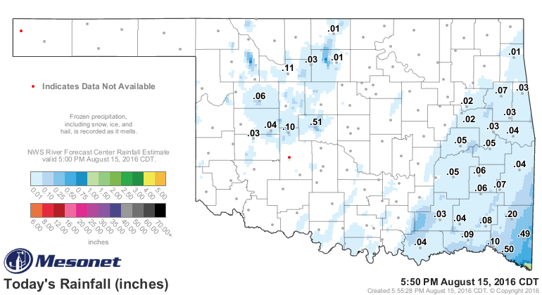
Mighty nice break in the heat and humidity over the weekend and the best part is this relatively mild weather for August looks to continue for a while. Rainfall today was largely confined to the more eastern counties and the associated cloud cover really helped hold temperatures down. Notice the rainfall map and although the amounts were light, it sure made a difference in the daytime highs as you can see on the max/min temperature map. A number of locations stayed in the 70s which for August is remarkable.
[img]
[img]
The clouds and associated light showers are due to the remnants of the system that brought record setting rainfall and flooding along the La coast as you can see on this map. Well over 20” of rainfall occurred, almost all of which fell last Friday and Saturday. I point this out because that same system basically robbed us of the moisture and rainfall that had been anticipated over in Green Country this past weekend. That system stalled out over the Gulf coast before eventually wobbling around just far enough westward for those showers over our more eastern counties today.
[img]
Now that it is being ejected to the NE, that means we will have mostly fair skies for the overnight hours and mostly sunny skies for much of the day Tuesday. Our winds will remain light which together with the mostly fair skies and dew points in the 60s will allow our overnight lows to drop into the low-mid 60s by early morning. Lots of sunshine during the day will result in afternoon temperatures back up to near 90, but that is still below normal for this time of year and with dew points holding in the 60s, the relative humidity will drop off to near 40% during the heat of the day which is not too bad either. Not only that, but our winds will be very light from the SE at less than 10 mph.
For Wednesday, a stronger S wind will result in a warmer start with upper 60s expected along with a few more clouds in the sky. Humidity levels will also be a bit higher but with a daytime high near 90, it will not be too uncomfortable, particularly in relation to last week.
After that, as you can see on our forecast page, more cloud cover is expected for Thu & Fri along with increasing chances of showers/storms due to a disturbance aloft moving over the state. The cloud cover will keep our daytime highs in the 80s and then another rather strong cool front for August looks to arrive on Saturday. This will also be accompanied with a chance of showers/storms but the shift to northerly winds will knock temperatures back down both at night as well as during the day through the weekend and going into the following week.
Not only that, but the good news is that the 8-14 day outlook continues to suggest temperatures running below normal and our rain chances above normal. If that verifies, that would certainly keep any more triple digit temperatures at bay for the rest of August. Of course, we can get triple digits during September, so am not about to go out on a limb and suggest we are through with triple digits for this year. But, at least the trends aloft to this point are not supportive of another heat dome building over the state as was the case the last few weeks.
[img]
[img]
So, stay tuned and check back for updates.
Dick Faurot

Get The Daily Update!
Be among the first to get breaking news, weather, and general news updates from News on 6 delivered right to your inbox!
More Like This
August 15th, 2016

September 29th, 2024

September 17th, 2024

Top Headlines

December 11th, 2024

December 11th, 2024
December 11th, 2024

December 11th, 2024