

Cool but Dry next Few Days.
Cool, stable weather pattern for the rest of the week.Wednesday, February 27th 2013, 3:18 pm


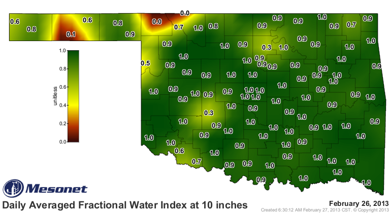
In yesterday's blog, I mentioned we would take a look at the soil moisture profile across the state. We have received some good, soaking rains/snow over the last week or so and that has really improved our soil moisture at the 10" level as the map on the right shows. However, as also mentioned yesterday, just because the ground is now wet does not mean the drought is over. Our rivers, lakes, streams and ponds are still quite low and we have not yet received enough run-off moisture to get them back to where they need to be. Also, the wettest time of the year is just ahead and if the Spring rains fail us this year as they did last year, it will not take long for our soils to dry back out as well.
After the active weather of the past week or so, the rest of this week and into at least early next week look to be rather quiet. In fact, the QPF map on the right clearly shows our chances of any additional precipitation during that period are pretty much nil.
That means the main forecast challenge in the coming days will be temperatures. And, the main wild card in the temperature forecast is cloud cover or lack thereof. For example, when the clouds cleared out late this morning, temperatures responded rather quickly. We are gaining a couple of minutes of potential sunlight each day at this time of year and the sun is getting higher in the sky. So, when the clouds do clear out, temperatures can respond rather quickly as was the case today.
Thursday should see enough sunshine for daytime highs to reach back into the mid-upper 40s but more cloud cover is expected for the Fri/Sat time frame. Also, a re-enforcing surge of cooler air will be arriving keeping us with brisk northerly winds through Saturday at least. As a result, have dropped the daytime temperatures for Fri/Sat into the lower 40s. However, if we should get lucky and get more sunshine than now anticipated, we would be several degrees warmer than now forecast.
Southerly winds will finally return for Sun/Mon to warm things back up to near normal during the day. Another cool front is on tap to arrive Monday night, but will be moisture starved so should be dry. It will also be followed by somewhat cooler conditions, but this does not appear to be an overly strong system.
By the way, as you look at the temperatures over this forecast cycle, keep in mind that our normal diurnal temperature range at this time of year is the mid 30s at night and the upper 50s during the day.
So, stay tuned and check back for updates.
Dick Faurot

Get The Daily Update!
Be among the first to get breaking news, weather, and general news updates from News on 6 delivered right to your inbox!
More Like This
February 27th, 2013

September 29th, 2024

September 17th, 2024

Top Headlines

December 14th, 2024

December 14th, 2024

December 14th, 2024

December 14th, 2024