

A Cold Rain for Tuesday, Snow Possibly Tuesday Night.
Cold and rainy for much of Tuesday, rain/snow mix and possibly all snow for a time Tuesday night.Monday, February 11th 2013, 3:38 pm

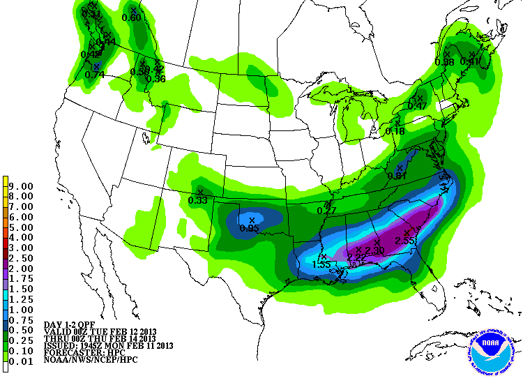
The updated QPF map on the right continues to suggest ½" or more of precipitation for much of the state Tuesday and Tuesday night which will certainly be welcome. The problem is that the precipitation type remains questionable due to the presence of warm air near the surface, at least on the eastern side of the state. For our more western neighbors, snow will begin falling by early Tuesday morning and there will be the potential for 6" or more in some locations by the time it ends Tuesday night. For EOK, the profiles of temperature and moisture strongly suggest a rain event starting by late morning or early afternoon. However, as we get into the evening and overnight hours colder air aloft will be dropping closer to the surface which should result in a rain/snow mix. Also, there will be a window of opportunity for a brief period of all snow before it comes to an end by early Wednesday morning.
This scenario is strongly dependent on the exact track of the main storm system aloft and the relatively warm air near the surface. A change in the track of the storm system could bring the rain/snow line further north or south. Also, a change of just a few degrees in the near surface layer of warmer air could result in a significant change in the location and amount of any wintry precipitation. These uncertainties should be fine-tuned as better data comes in this evening. Another consideration is the potential for a localized snow burst which would be capable of overwhelming the warmer air near the surface and produce some brief periods of a heavy, wet snow.
At any rate, not going to issue and milk and bread emergency just yet
Given the above, after the sunny skies and temperatures reaching the lower 50s today, the cloudy skies, NE winds, and precipitation will hold us in the upper 30s to near 40 for tonight and Tuesday. At least temperatures will be above freezing throughout the event with the possible exception of early Wednesday morning which would be as the precipitation is ending anyway. So, barring any major surprises, wet roads will be the main travel hazard and icy or snow packed roads a minimal concern unless you are headed to the more western counties of our state.
Wednesday and Thursday look to be fairly quiet although another cold front will be arriving during the day Thursday followed by chilly conditions for Friday and Saturday. Also, some energy aloft could wring out some snow flurries on Friday with possibly a light dusting in some areas.
A return to southerly winds and a bit of a warming trend is expected for Sunday into Monday followed by more unsettled weather during that following week.
So, stay tuned and check back for updates.
Dick Faurot

Get The Daily Update!
Be among the first to get breaking news, weather, and general news updates from News on 6 delivered right to your inbox!
More Like This
February 11th, 2013

September 29th, 2024

September 17th, 2024

Top Headlines

December 11th, 2024

December 11th, 2024

December 11th, 2024

December 11th, 2024