

Christmas Snowstorm Update
All signs are pointing to a White Christmas for nearly the entire state of Oklahoma.Monday, December 24th 2012, 11:34 am

All signs are pointing to a White Christmas for nearly the entire state of Oklahoma. As if on cue, Mother Nature's timing of the snow couldn't be better for a Christmas dreams come true. However, the snowstorm is likely to bring frightful weather to travelers later in the day. Here's the latest on our first significant snowstorm in nearly two years:
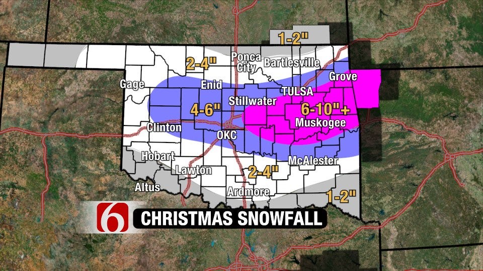
The cold air is already in place – the first component to the snowstorm. The moisture and energy for the storm is still a ways off as I write this on Christmas Eve, but it's a fast-mover. By as early as mid-morning Christmas Day, light snow north of I-44 and a wintry mix south will start to break out in central and eastern Oklahoma. Travel issues will likely hold off in Green Country until the afternoon when the upper-level low deepens and a band of moderate-heavy snow sets up in the region. It's always tricky to pinpoint the heaviest snow, but most of the computer models have settled on an area between Highway 412 (near Tulsa) and southeast Oklahoma. That puts somewhere in our region under the gun for snow totals nearing 10 inches (or even higher).
Outside of the heaviest snow band, snow totals will be on the order of 3-8" with even lesser amounts near the Oklahoma/Kansas border. The map above is our best estimate of snow amounts through Christmas night. The snow will wrap up late Tuesday evening from west to east. Assuming Tulsa officially receives over 1.3" of snow, we will break an all-time daily snowfall record for Christmas Day!
Beyond Tuesday early afternoon, travel is highly discouraged, especially in the corridor of highest snow totals. Not only will the snow be heavy, but the winds will be gusting up to and over 30mph. Technically, that's not a blizzard, but there may be a few instances of white-out conditions. Soil temperatures are above-freezing, but snow will eventually fall at a heavier rate than the snow can melt. Initially, bridges and overpasses will be slick, but most roadways may eventually become snow-covered, slick, and even impassable with drifting snow. Temperatures will continue to plummet Christmas night, so travel conditions will remain poor, even after the snow lets up.
Have an alternative plan if you planned to drive after tomorrow morning in the region. If you must travel, pack a survival kit, including a blanket, flashlight, food, and water in your vehicle. No one wants to be stranded on the side of a road or in a snow drift Christmas Day (or anytime for that matter!)
The snow will stick around for a couple days at least as a frigid air mass remains in place. We'll see temperatures finally sneak above freezing on Thursday. Another fast-moving, but weaker, system may bring a light wintry mix on Friday as well.
We'll keep you updated throughout the snowstorm on-air and on-line. Be sure to follow me on Twitter: @GroganontheGO and "like" me on Facebook for all the latest!

Get The Daily Update!
Be among the first to get breaking news, weather, and general news updates from News on 6 delivered right to your inbox!
More Like This
December 24th, 2012

September 29th, 2024

September 17th, 2024

Top Headlines

December 14th, 2024

December 14th, 2024

December 14th, 2024

December 14th, 2024