

Wide Range of Christmas Day Possibilities Explained.
Here is an example of the wide range of forecast possibilities for Christmas Day based on computer runs just 6 hours apart.Thursday, December 20th 2012, 9:38 am


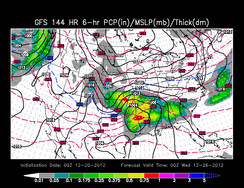
If you have been wondering about the reason why you may have heard wildly conflicting forecasts regarding the Christmas time period, perhaps the two maps on the right will provide some insight into the quandary we sometimes find ourselves as forecasters. Both maps show the 6 hour forecast precipitation ending at 6 PM Christmas Day and are generated by one of the longer range computer models we rely on. This particular model is referred to as the GFS and generates forecasts out to 384 hours.
The first map was generated based on data from 6 PM last night, the second map was based on data from midnight. The differences between the two are striking. The most recent map, which is the one from midnight has us dry through Christmas Day. The map that was generated just 6 hours earlier has us very wet with rain likely changing over to snow. We have also been receiving conflicting guidance from the ECMWF which is the European model and which quite frankly is usually more dependable. It has been flipping from run to run as well.
Bottom line is that all available guidance remains very inconsistent which makes for a very low confidence forecast for Christmas Day. The possibilities range from a seasonally cool, dry day, to a cold, wet day with rain changing to snow. Obviously, from a forecast perspective, we would like to see more internal and run to run consistency; particularly for such a critical time period with all the travel and other activities that typically surround Christmas.
As to why the guidance is so inconsistent, keep in mind we are talking about a system that is currently in the general vicinity of the Gulf of Alaska. Our observational network is best over land; over remote locations and the oceans the base data that goes into the computer models comes from remote sensing via satellites and that data set is just not as good as our land based network. Therein lies the problem which means we will likely continue to see wide swings in the model output for Christmas Day until we get better sampling and that will not happen until over the course of the weekend.
In a situation like this, we try to maintain some internal consistency as a staff and try to avoid the wild swings based on a more recent computer model run, particularly since they are flipping from one run to the next. It is important to realize that this is a low confidence scenario we are facing at the current time frame and that the specifics will probably not come into better focus until we get better sampling which is not likely until over the weekend. That may place you in a time crunch regarding the impact it will have on travel plans or other plans over Christmas, but the way things stand right now, it is unavoidable.
So, stay tuned and check back for updates.
Dick Faurot

Get The Daily Update!
Be among the first to get breaking news, weather, and general news updates from News on 6 delivered right to your inbox!
More Like This
December 20th, 2012

September 29th, 2024

September 17th, 2024

Top Headlines

December 12th, 2024

December 12th, 2024

December 12th, 2024
