Taste of Fall Almost Here
As we've been advertising all week, a strong cold front will take a direct course from Canada to Oklahoma and beyond. It's on its way and will finally erase our triple-digit heat, and hopefully bring some rain.Thursday, September 6th 2012, 3:31 pm
37 - That is the number of 100º+ days that Tulsa has dealt with in 2012. It still isn't quite as bad as last year when we recorded 44 days at or above the century mark. When you consider our annual average is a mere 11 days in that extremely hot category, we can see how abnormal this run of weather has been. Here's the good news… I think the tally of those days this year will end for Tulsa and the region after tomorrow.
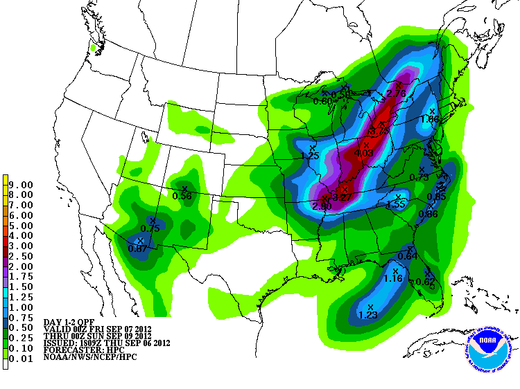
As we've been advertising all week, a strong cold front will take a direct course from Canada to Oklahoma and beyond. In fact, it's already heading this way, promising to bring cooling winds and temperatures down into the lower to mid-50s at night. For the first time in months, I won't be joking when I say you'll want to find a jacket! Along with the cooler weather, we are counting on this system to bring us some rain. The latest computer models are less "bullish" with rain totals, but the strength of this front, running into a hot, steamy air mass should promote widespread showers and thunderstorms. The latest rainfall forecast from the Hydrometeorological Prediction Center shows low rain totals through Saturday (above), but there will likely be localized rain amounts over half an inch. The timing isn't exactly the best. We expect the front to arrive mid-afternoon with showers and thunderstorms to follow, which would likely impact some high school football games. If anything, the northerly winds will be an added challenge! Those winds will be the winds of change as we see our first downward step into a more autumnal weather pattern.
So, here's how we break it down. We've got a few rain chances between now and Friday night. Until then, the heat will persist. Another 100º day isn't out of the question. Then, the cool-down arrives with highs in the *70s* by Saturday! (We won't know what to do with ourselves!) As is the case with weather, especially around here, it won't be a permanent change from one season to the other. However, even with a warm-up expected next week, the air mass won't likely be able to recover to the same heat levels we've endured recently. That is why we're pretty confident when we say the worst of summer heat is about over.
Get ready for that taste of fall! I know the relief will be most-welcome. Now if only we could get some wetter storm systems in here…
Be sure to follow me on Twitter: @GroganontheGO and "like" me on Facebook!
More Like This
September 6th, 2012
September 29th, 2024
September 17th, 2024
Top Headlines
December 12th, 2024
December 12th, 2024
December 12th, 2024
December 12th, 2024


