Another Cold Snap Before Weekend Warmup For Northeastern Oklahoma
Temperatures will be falling later today and could be in the lower 40s by the evening commute along with gusty northwest winds increasing this evening.Tuesday, February 25th 2020, 6:29 am
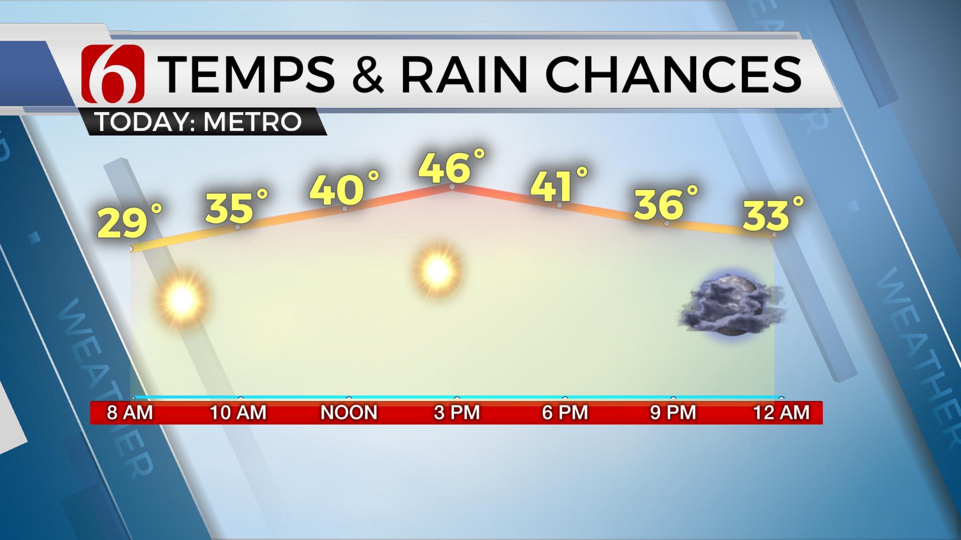
We’re starting with temps in the upper 30s and lower 40s and will finish with highs in the upper 40s or lower 50s early afternoon before some light precipitation chances arrive later tonight into Wednesday morning, including the chance of some rain changing to light snow showers. Temperatures will be falling later today and could be in the lower 40s by the evening commute along with gusty northwest winds increasing this evening.

Our next upper level wave will quickly drop down the intermountain region and into the central plains this afternoon before moving across Southeastern Kansas and Northeastern OK overnight. Slightly colder air with this system brings the chance for light showers to develop into snow showers as the system passes over the area tonight, but any impactful snow once again appears unlikely for most of our area. A small dusting will be possible across the state line region into northwestern Arkansas. The Tulsa metro should see some showers developing later this afternoon and evening and would mix with or change to light snow around midnight. Any precipitation would end around 3am to 5am Wednesday morning.

The main upper level system will be exiting the region early Wednesday morning taking the precip out of the area, but colder air will remain Wednesday through Thursday morning before the airmass modifies into Friday. Wednesday would be the coldest day of the next 7 with morning lows in the upper 20s to lower 30s and highs only in the upper 30s to lower 40s. Thursday morning would be the coldest morning with lows in the lower to mid-20s, but afternoon temps would modify quickly while reaching the mid-50s by afternoon along with a sunshine-cloud mix. Friday into the weekend signals a pattern change after a fast-moving upper system clears the area Friday morning to midday. This pattern change will bring warmer weather quickly into the southern plains, with Fridays highs in the upper 50s, Saturday near 70 and Sunday into the mid or upper 60s. Another stronger looking system will near the state for the middle of next week.
Thanks for reading the Tuesday morning weather discussion and blog.
Have a super great day!
Alan Crone
More Like This
February 25th, 2020
November 30th, 2022
November 1st, 2022
August 26th, 2022
Top Headlines
December 11th, 2024
December 10th, 2024
December 10th, 2024
December 10th, 2024


