Another Heat Advisory Issued For Northeastern Oklahoma
Another heat advisory will be issued for the day across northeastern OK and vicinity with afternoon heat indices nearing 105 to 112 in some locations.Wednesday, July 1st 2020, 5:53 am
TULSA, Okla. -
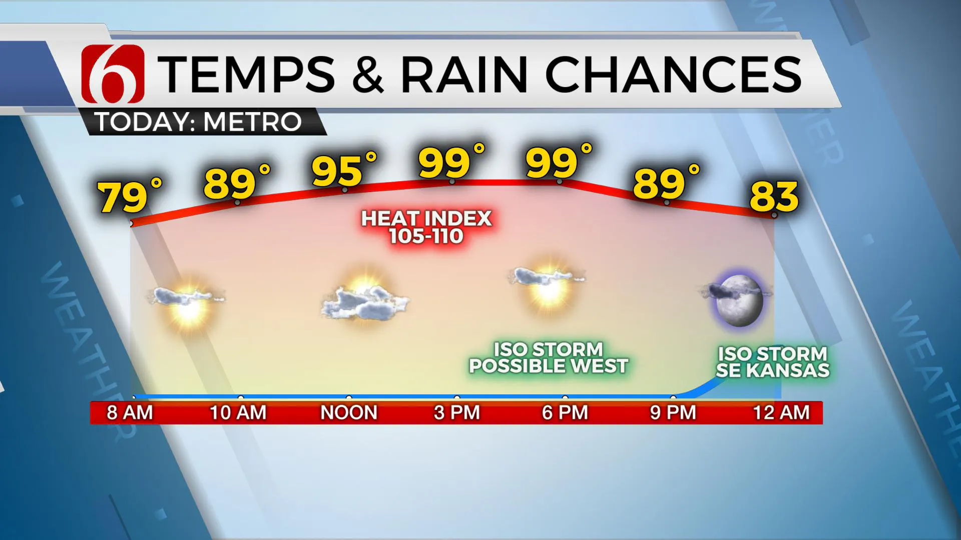
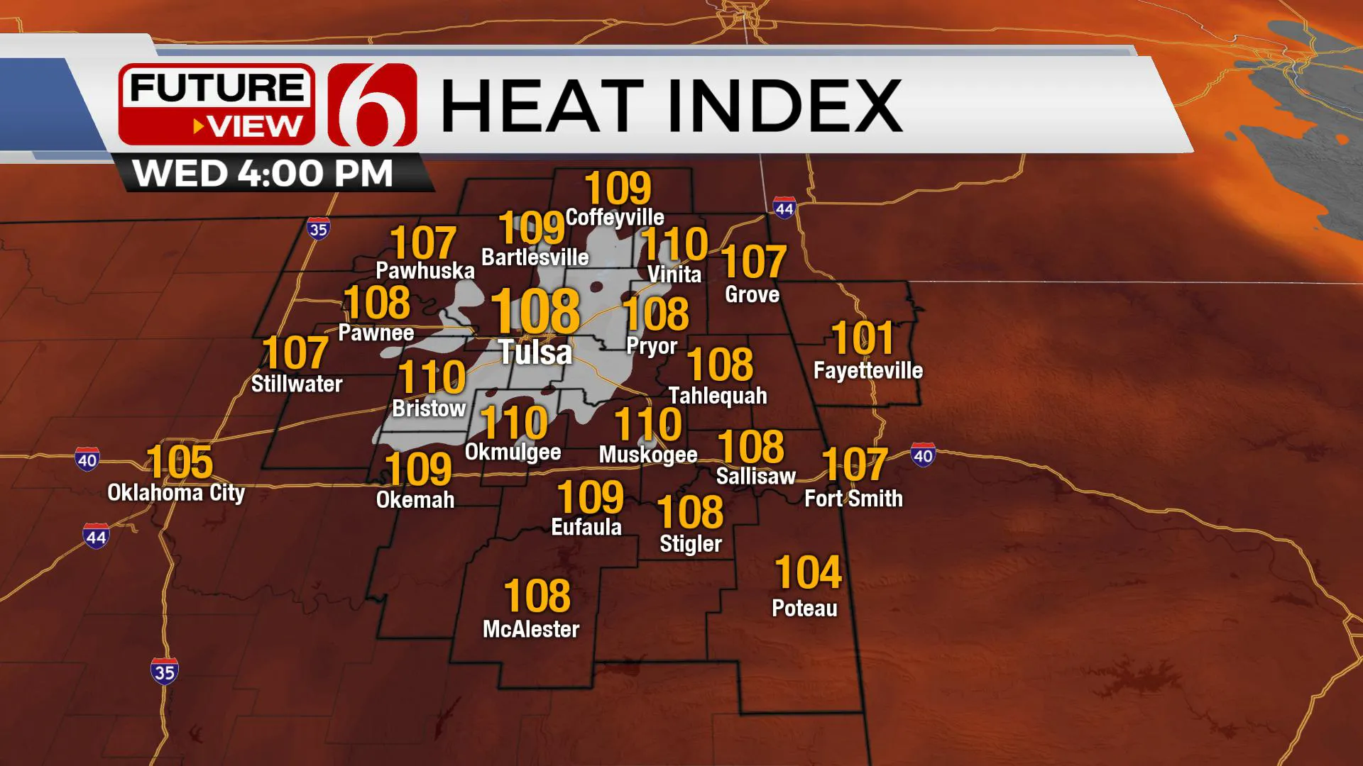
Another heat advisory will be issued for the day across northeastern OK and vicinity with afternoon heat indices nearing 105 to 112 in some locations.
I anticipate this will also be the case Thursday before some minor relief arrives Friday through the weekend as a weak boundary approaches from the northeast. This front may not survive all the way south of the metro but should bring a chance for a few storms followed by a minor reduction in heat values Friday through the weekend. The upper air pattern remains favorable for a few isolated storms during the 4th.

The ridge of high pressure remains in place nearby this morning and continues to keep most of the active weather away from the region for most of the day. This is not “The Summer ridge” that keeps everything away. We’ll continue to see a few isolated storm chances during the next 24 to 36 hours even with the 850 thermal ridge parked to our west.
A cluster of storms will drop across the Missouri Valley this morning, well northeast of the state, but may shove a weak outflow boundary near northern OK later this afternoon. Some hi-res data develops a storm or two along this boundary and clips part of southeastern Kansas and northeastern OK later this evening through early Thursday morning. I’ll not include this probability on the big 7-day planner but will make mention for our neighbors across far NE OK.

The main center of the mid-level ridge will remain west of the area Thursday through the weekend allowing a northerly upper air flow to bring a boundary nearby Thursday night into Friday. Some data support a small cluster of storms during this period moving from southward across the area. We’re keeping our probabilities on the low side for now but should experience a few storms either later Thursday night or Friday morning. We could have a repeat performance Friday night, but possibly more southward across east-central OK.These are currently low probability events.
Saturday, on the 4th, a few scattered storms will be possible with highs in the lower to mid-90s but also with a reduction in heat indices. Basically, from Friday through the weekend, we should not meet heat advisory criteria.
The ridge may attempt to move back eastward by late next week with increasing temps and heat index values again for the region.
Highs today will reach 96-99 in the metro with heat index members nearing 107 to 112. Highs tomorrow may be nearing 99 to 102 before dropping into the mid 90S Friday.
Thanks for reading the Wednesday morning weather discussion and blog.
More Like This
July 1st, 2020
August 8th, 2023
July 4th, 2023
May 8th, 2023
Top Headlines
December 10th, 2024
December 10th, 2024
December 10th, 2024
December 10th, 2024


