Active Weather Pattern Continues For Northeastern Oklahoma
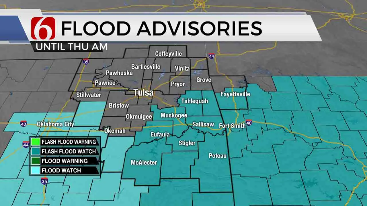
The active pattern will remain across part of the state for another 24 to 36 hours before seeing some drying trends from the north to south. Flood watches will remain across southern and far eastern OK and part of western Arkansas today.Wednesday, September 2nd 2020, 9:13 am
The active pattern will remain across part of the state for another 24 to 36 hours before seeing some drying trends from the north to south. Flood watches will remain across southern and far eastern OK and part of western Arkansas today. The metro is not included in a flash flood watch but may still experience some occasional moderate to heavy rainfall. The probability for the metro and northern sections should continue to “thin-out” later while southern sections may continue with another round of moderate to heavy rainfall later tonight through Thursday morning. Highs this afternoon will stay in the lower 80s near Tulsa and into the upper 70s across southeastern sections. The pattern will begin changing this weekend into early next week with a taste of fall weather moving across the central and eastern sections of the nation, including central and eastern Oklahoma. The data has been consistent in bringing this pattern change but the specifics regarding exact timing of some important features may continue to change for the next few days.

The rainfall has been significant. Amounts from 3 to 8 inches have already been reported yesterday across the southern third of the area, and additional heavy rainfall is likely again this morning in some of these same areas. Residents along the Highway 270 corridor region southward should remain alert for flooded roadways and low water crossing areas. Significant flooding may occur with any additional heavy rainfall in these areas across southern Oklahoma.
Thursday morning, the focus for most activity will be along the Red River or along extreme eastern Oklahoma into western Ark. I have not included any precipitation for the metro or northern OK after the Thursday morning period. Friday a weak boundary should be south of the region bringing north winds, slightly lower humidity and pleasant conditions for the day and evening while a few storms may develop across southeastern sections of the state.
South winds will return Saturday and Sunday in advance of the next cold front arriving sometime early next week. At this point, we’ll keep Monday’s afternoon highs in the lower 80s. While the data suggest a strong front, the exact time of arrival is not consistent. I’ll have a slight chance for a few storms Sunday late into Monday morning, and higher chances Tuesday. A nice fall preview will eventually arrive next week. Stay tuned.
Two additional tropical systems are now up and running. Tropical Storm NANA is located across the southern Caribbean and will impact central America. Omar is located off the Carolina coastline this morning but will move east and have no direct impact on the U.S. mainland.
Thanks for reading the Wednesday morning weather discussion and blog.
Have a super great day!
Alan Crone
More Like This
September 2nd, 2020
August 8th, 2023
July 4th, 2023
May 8th, 2023
Top Headlines
December 12th, 2024
December 12th, 2024
December 12th, 2024
December 12th, 2024


