Early Morning Lows In The 40s With Afternoon Highs Reaching Upper 70s
Election Day weather looks great across the state of Oklahoma and for most of the nation. An incoming system spreads precipitation and winds across the pacific northwest while another clipper type system exits the far northeastern section of the nation. Most of the country looks rather uneventful regarding any big weather issues for election dayTuesday, November 3rd 2020, 7:18 am
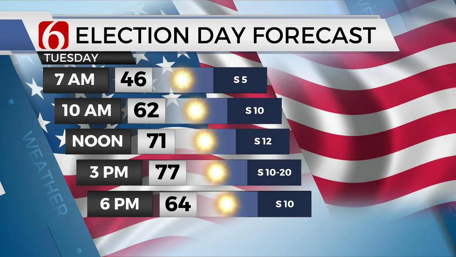
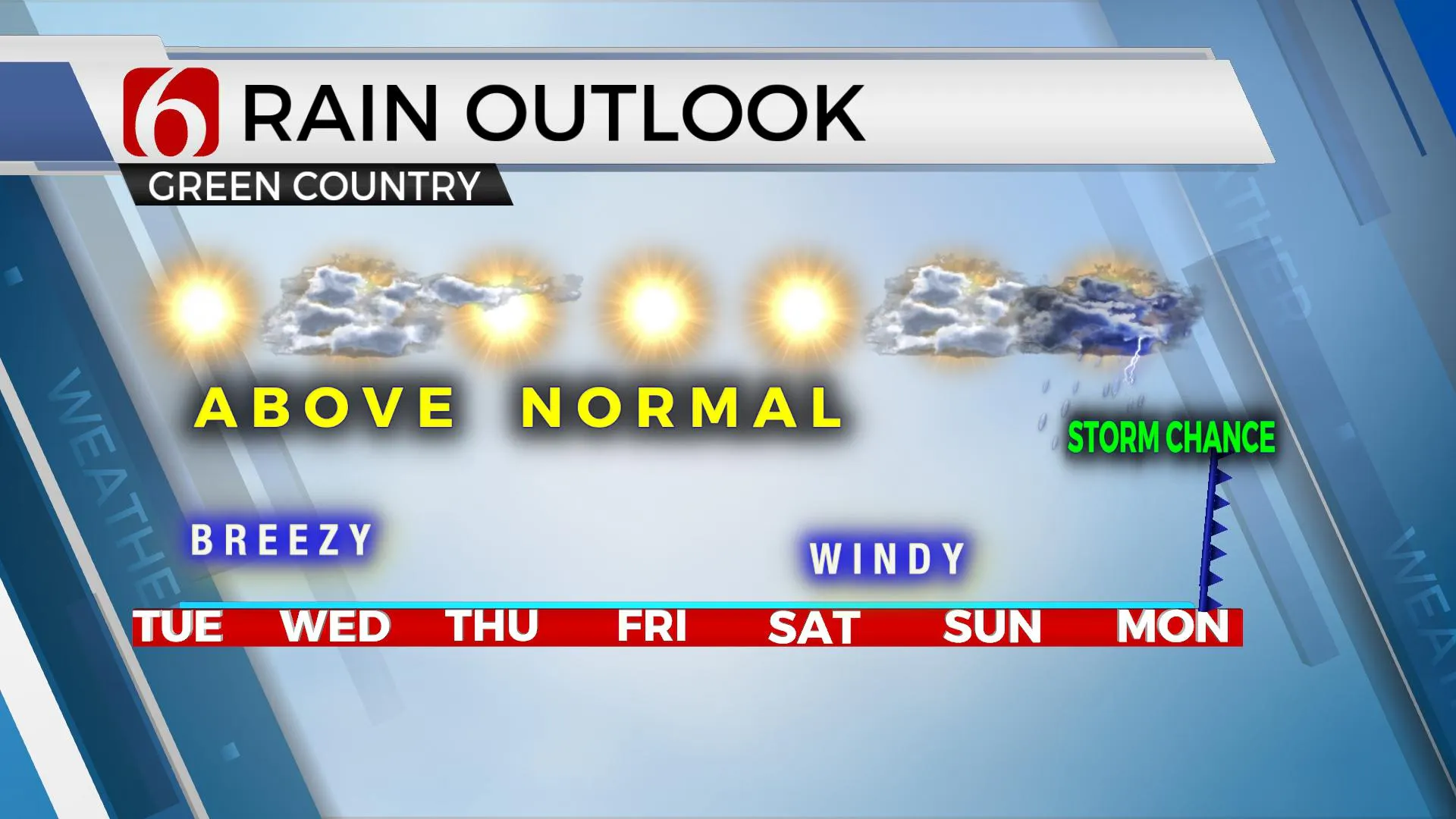
Election Day weather looks great across the state of Oklahoma and for most of the nation. An incoming system spreads precipitation and winds across the pacific northwest while another clipper type system exits the far northeastern section of the nation. Most of the country looks rather uneventful regarding any big weather issues for election day. Our forecast starts with lows in the 40s before moving into the upper 60s by the noon hour and finishing with highs reaching 77 this afternoon. Gusty southwest winds will be likely for the middle of the day and early afternoon with speeds from 12 to 22 mph along with sunny conditions. The upper airflow will bring a short-wave trough across the desert southwest tonight and eject this system across central Kansas Wednesday. This system will bring a few mid and high-level clouds to the region but I’m not anticipating any precipitation or major changes from a sensible weather standpoint. Lows will start Wednesday morning in the upper 40s and lower 50s while topping out in the lower to mid-70s along with gusty south winds around 15 to 30 mph. The rest of the workweek also appears very pleasant and rather benign with lows in the 50s and highs in the mid-70s. South winds will prevail around 10 to 20 mph, but will increase more into the weekend as our pattern changes.

The upper air flow will become from the southwest this weekend as a major pattern change occurs. A strong upper trough will develop soon across the Aleutian Island chains and drop southeast into the western U.S. Thursday and Friday. A surface area of low pressure should develop somewhere along the Lee of the Rockies Friday or Saturday as the first wave ejects north into the northern plains. As the pressure drops, winds will respond from the south and become quite gusty to windy this weekend across our area with morning lows in the 50s and afternoon highs reaching the lower to mid-70s. This long stretch of southerly flow will also pump low-level moisture into the area by this weekend.
 Sunday into Monday the lead wave ejects around the base of the trough and brings a few showers or storms near the eastern third of the state Sunday, but the main trough will remain to our west and not pass the area until either Monday evening or Tuesday. This is when a strong surface cold front will roll across the state bringing increasing thunderstorm chances followed by another shot of colder weather Tuesday into the most of next week. This system is a rather robust looking upper trough and would support even deep layer wind shear for strong to severe storms, but many questions remain about the frontal boundary and whether storms will be post-frontal or pre-frontal. No mentions for strong or severe storms will be included for this period of the forecast at this point, but it’s something I’ll be watching as the weekend trough nears the state.
Thanks for reading the Tuesday morning weather discussion and blog.
Have a super great day!
Alan Crone
KOTV
Be sure and check out my daily weather, mini podcast. Search for NewsOn6 and “Weather Out The Door” on Spotify, The Tune-In Radio app, Stitcher, Apple podcasts, and right here at SoundCloud.
More Like This
November 3rd, 2020
February 14th, 2022
January 26th, 2022
January 25th, 2022
Top Headlines
December 14th, 2024
December 14th, 2024
December 14th, 2024
December 14th, 2024


