Wet, Cooler Conditions Arrive, Cold Front Moves Across The Area
Wet and cooler conditions arrive for a while this morning as a pattern change is underway. A strong cold front is moving across the area with showers and some thunder. Temps will start in the 50s but will drop into the 40s by theFriday, December 11th 2020, 6:21 am
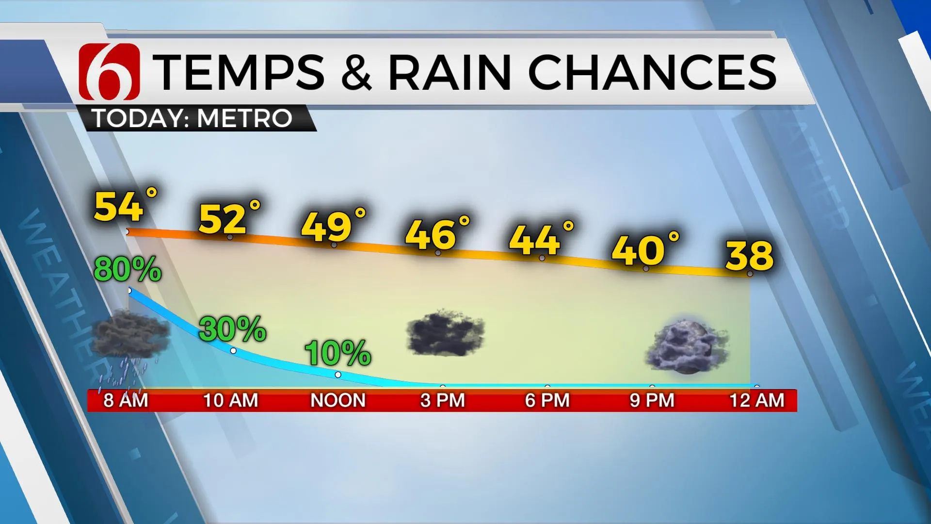
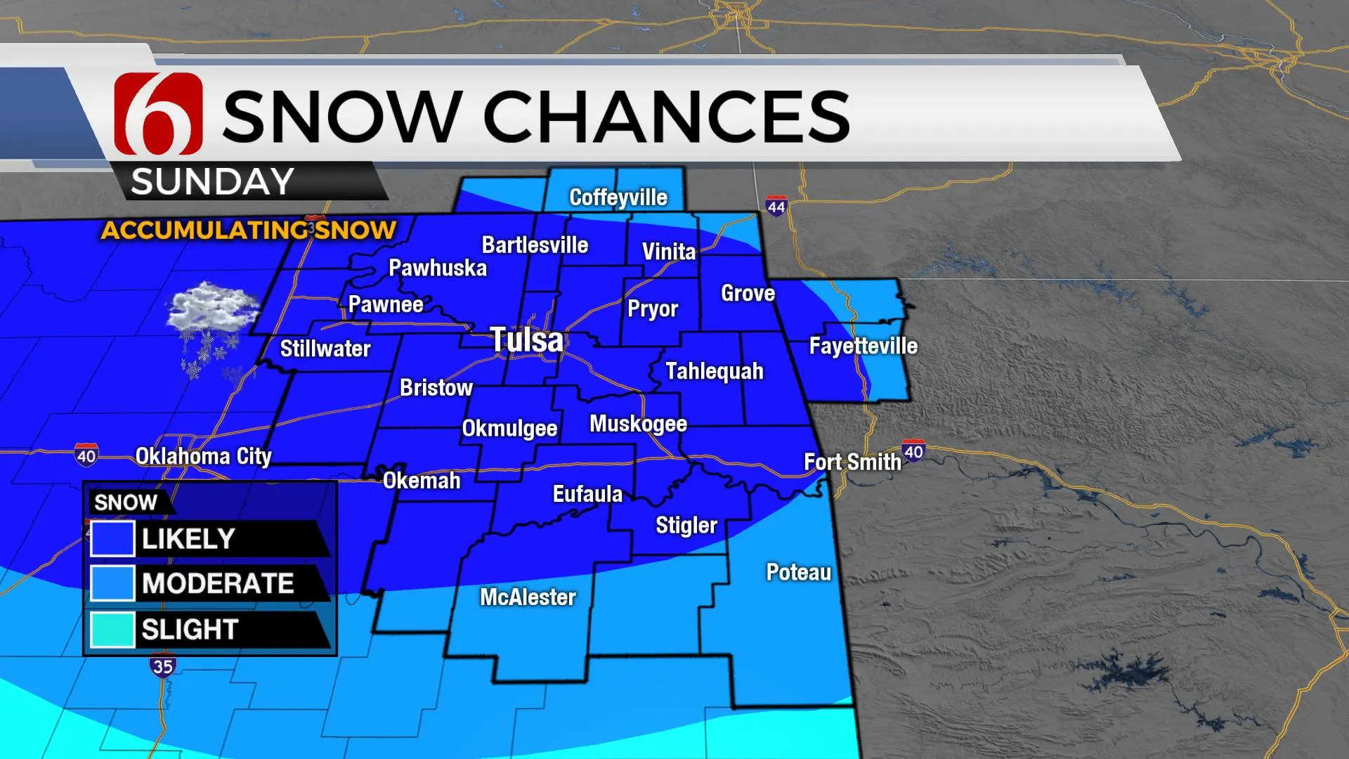
Wet and cooler conditions arrive for a while this morning as a pattern change is underway. A strong cold front is moving across the area with showers and some thunder. Temps will start in the 50s but will drop into the 40s by the afternoon with gusty northwest winds. No severe weather is expected across northeastern OK but a few stronger cells may briefly occur across far southeastern OK and northeast Texas later this afternoon as the front encounters these areas. Regarding the Tulsa metro, most of the shower activity will quickly exit northern OK during the morning hours. Saturday will remain cold with lows in the 30s and highs in the mid-40s. A few sprinkles or showers may continue early Saturday morning across far northeastern OK, but this chance remains very low. Our next system arrives Sunday and provides a chance of accumulating snow across northeastern Oklahoma.

The main upper-level short-wave for Sunday will dive southeast from the intermountain region and transit across the state midday with cold air from the mid and upper levels through the lower layer of the atmosphere. Temps should support all snow for this event for the northern section with a rain-snow mix across the south. Models continue to differ slightly on the exact location of some heavy snow bands but seem to be converging near north-central to northeastern OK with a swath of moderate to heavy snow that could result in anywhere between 2 to 3 inches with locally higher totals possible. The main storm system this morning is off the coast of Juneau, Alaska. We still have lots of time and space before the system arrives across our area and forecast accumulations could change. The timing of the precip will begin Sunday morning northwest of the metro and quickly expand southeast by midday and exit the region late Sunday afternoon. Some travel will be impacted despite recent temps in the 60s and 70s. The rate of snowfall and colder air should overcome the relatively warm ground temps and snow is expected to accumulate on roadways across central and northern OK but may not have the same impacts across southern sections. Temps Sunday will remain in the 30s for the day along with northwest winds around 10 to 20 mph. I have lowered Monday’s temps based on the assumption of some snow on the ground across portions of the area with lows in the lower 20s and highs in the lower 40s along with sunshine and a return of south winds at 10 to 15 mph. Another fast-moving clipper system brushes the area Tuesday and may also produce a swath of rain and snow, but lower in accumulations and mostly across far northern OK. This pattern will remain active through at least the next 10 days, including near the Christmas Holiday period. Stay tuned.

Additional changes to the Sunday forecast will remain possible as the main storm system nears the state.
More Like This
December 11th, 2020
February 14th, 2022
January 26th, 2022
January 25th, 2022
Top Headlines
April 19th, 2024


