Damp And Windy Tuesday With A Lot More Rain To Come This Week
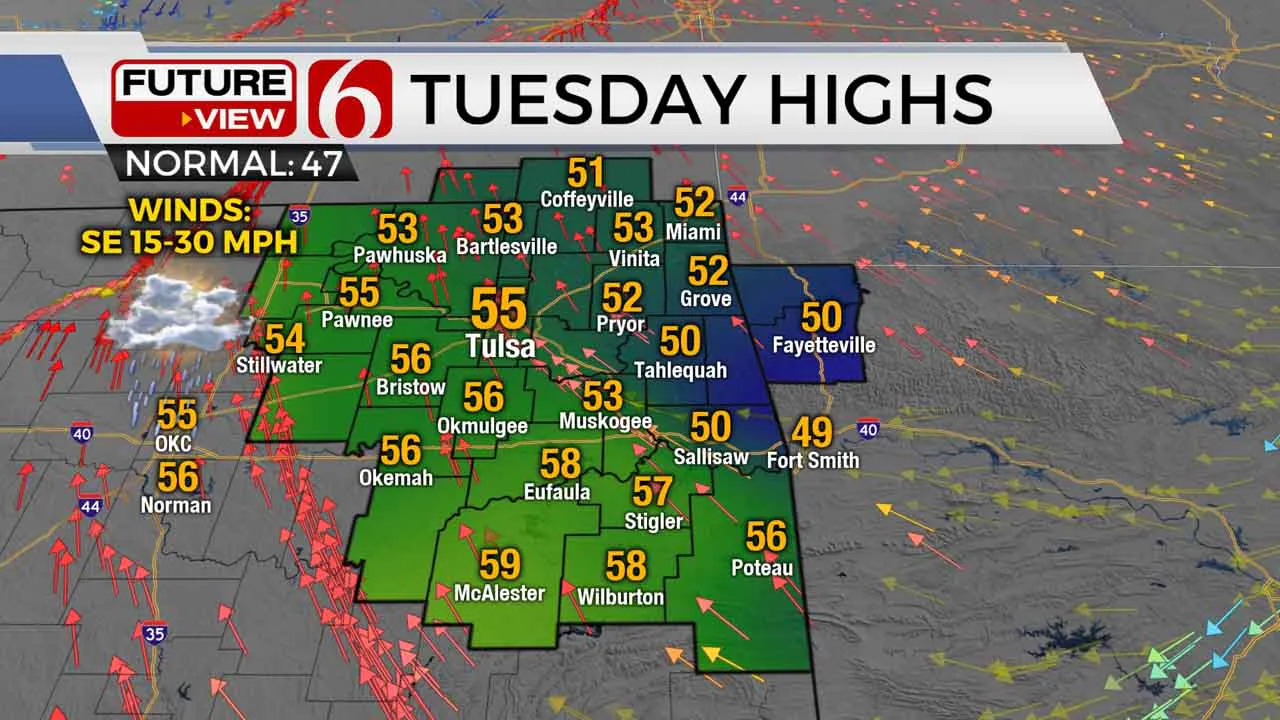
A damp start to our Tuesday morning is just the beginning of a soggy stretch that will take over for much of this week. Buckle up, we’ve got a lot to discuss! We’ve already had some areas of drizzle and light rain early this morning, though that will become spottier for the afternoon. Brisk southeast winds kick back in today, with gusts over 30 miles per hour. Highs will range from the lower 50s north of Tulsa to near 60 in southeastern Oklahoma under mostly cloudy skies. Steadier rains and embTuesday, December 29th 2020, 9:49 am
A damp start to our Tuesday morning is just the beginning of a soggy stretch that will take over for much of this week. Buckle up, we’ve got a lot to discuss!
We’ve already had some areas of drizzle and light rain early this morning, though that will become spottier for the afternoon. Brisk southeast winds kick back in today, with gusts over 30 miles per hour. Highs will range from the lower 50s north of Tulsa to near 60 in southeastern Oklahoma under mostly cloudy skies.
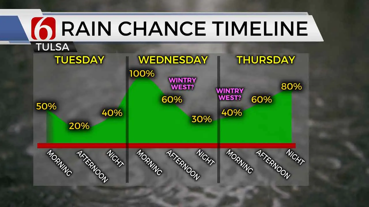
Steadier rains and embedded storms will gradually take shape west of Green Country tonight, and that widespread rainfall will slowly progress into eastern Oklahoma early Wednesday morning. Plan for a very soggy start Wednesday with some locally heavy rains expected.

Wednesday is the first of a few days, however, where the forecast is quite tricky. While widespread rains move across eastern Oklahoma Wednesday morning, a strong cold front will also be pushing through with temps falling from the 50s to the 30s during the day. If some moisture is still hanging around eastern Oklahoma by mid-day or Wednesday afternoon as the cold air “catches up”, it’s not out of the question that we could see a wintry mix changeover west of Tulsa that could lead to some minor accumulations. That setup is still uncertain, even just a day out, so plan on soggy conditions Wednesday regardless, and we’ll have to watch those Wednesday temperatures closely to see if wintry precipitation chances will increase.
By Wednesday night, the majority of precipitation, primarily in the form of cold rain, will shift into southeastern Oklahoma. The upper-level storm system then re-loads a bit as we head into New Year’s Eve. Another round of widespread precipitation will lift north out of Texas on New Year’s Eve Thursday, associated with a strong area of low pressure. The setup with this is also tricky.
Colder air should be entrenched across Oklahoma by New Year’s Eve Thursday, with temperatures below freezing west of Tulsa. This could lead to freezing rain Thursday morning west of Tulsa. However, the current track of this low-pressure system, and warmer temperatures above the ground, would suggest primarily cold rain once again Thursday afternoon into Thursday evening for most of eastern Oklahoma. Flooding may become a problem in southeastern Oklahoma by New Year’s Eve, with several inches of rain possible by then.

As temperatures above the ground and at the surface cool New Year’s Eve night, a changeover to a wintry mix or some snow looks possible across portions of Oklahoma. Again, given the current projection of the track of this low-pressure system, it would appear the best chance for wintry precipitation late New Year’s Eve night may set up just west of Green Country closer to I-35. But a small track shift could bring those wintry chances closer into our area. By early New Year’s Day morning, this system will be rapidly moving north and starting to pull away.
Still, the word of caution you hear from us with wintry systems: There’s still room for things to change! A slight nudge to the east in the track of this system, which is very much still possible, would result in better wintry precipitation chances shifting back into eastern Oklahoma. We’ll track that for you very closely over the next few days.
I hope you have a great Tuesday, Green Country! You can also follow me on Twitter @StephenNehrenz as well as my Facebook page Meteorologist Stephen Nehrenz to stay up to date with the very latest.
More Like This
December 29th, 2020
February 14th, 2022
January 26th, 2022
January 25th, 2022
Top Headlines
December 11th, 2024
December 11th, 2024
December 10th, 2024


