Additional Wintry Precipitation Expected Wednesday
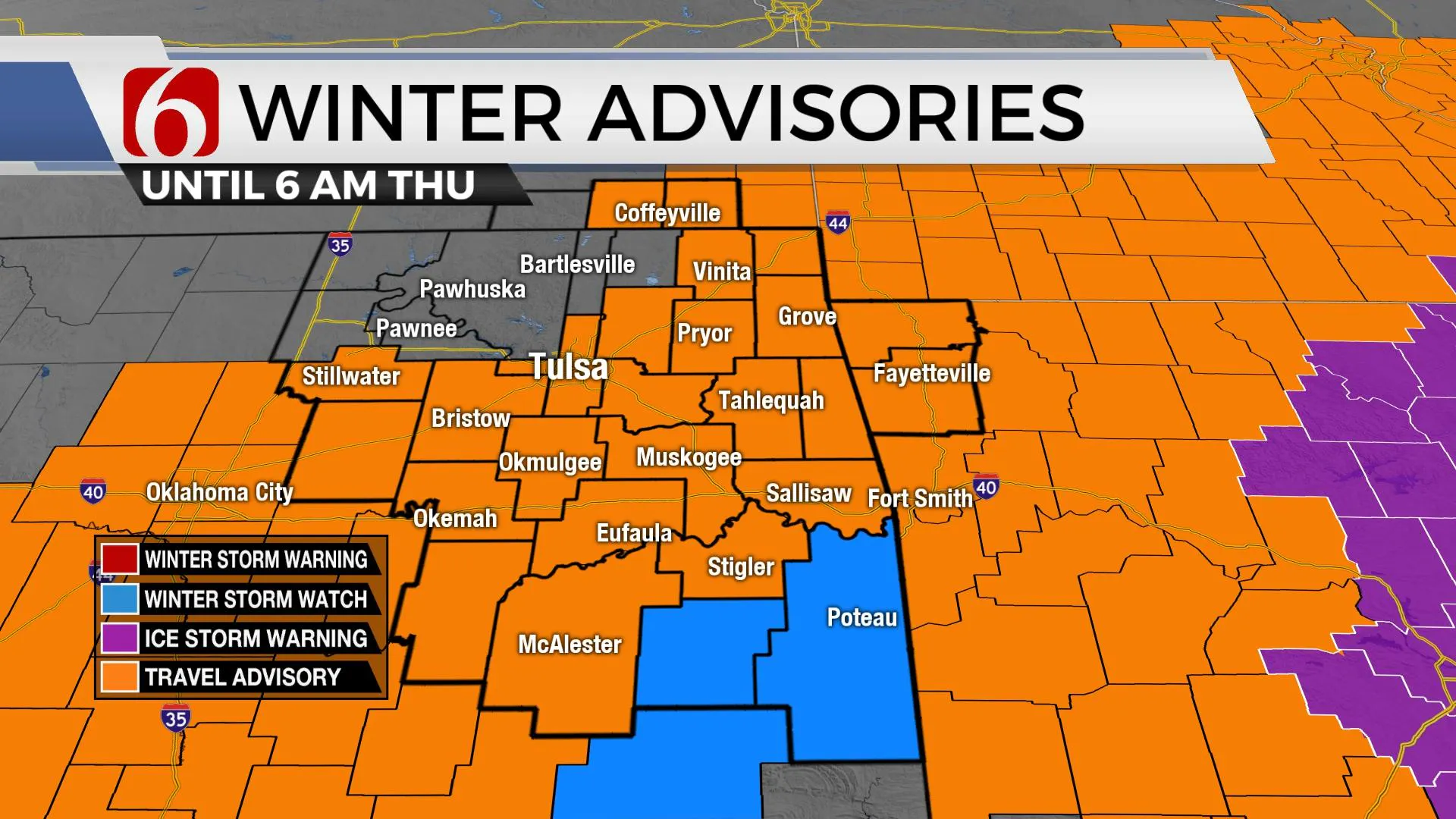
Moisture is moving up and over the shallow dome of cold air this morning and will produce additional wintry precip over a large area this morning before moving southward later this morning. Precip will fall in the form of light snow along the Ok-Kansas state line region, a mix of wintry precip near Tulsa, and mostly freezing rain and drizzle across southeastern to east-central OK. A winter weather advisory remains in effect for the day near and south of the Tulsa metro. Locations across far soutWednesday, February 10th 2021, 5:58 am
Moisture is moving up and over the shallow dome of cold air this morning and will produce additional wintry precip over a large area this morning before moving southward later this morning. Precip will fall in the form of light snow along the Ok-Kansas state line region, a mix of wintry precip near Tulsa, and mostly freezing rain and drizzle across southeastern to east-central OK. A winter weather advisory remains in effect for the day near and south of the Tulsa metro. Locations across far southeastern and east central OK may experience significant icing resulting in extremely dangerous travel. North winds from 15 to 25 mph will be possible in these areas and some minor, sporadic power outages may be possible due to ice accretion on lines and tree limbs. The projection for ice across southeastern OK does not meet ice storm warning criteria at this moment but it is close. Locations north, including near the metro will have lower chances for precipitation after the early morning hours with most of the focus remaining south for the day. Once again, highs will remain in the lower to mid-20s north and near the upper 20s across southeastern OK.

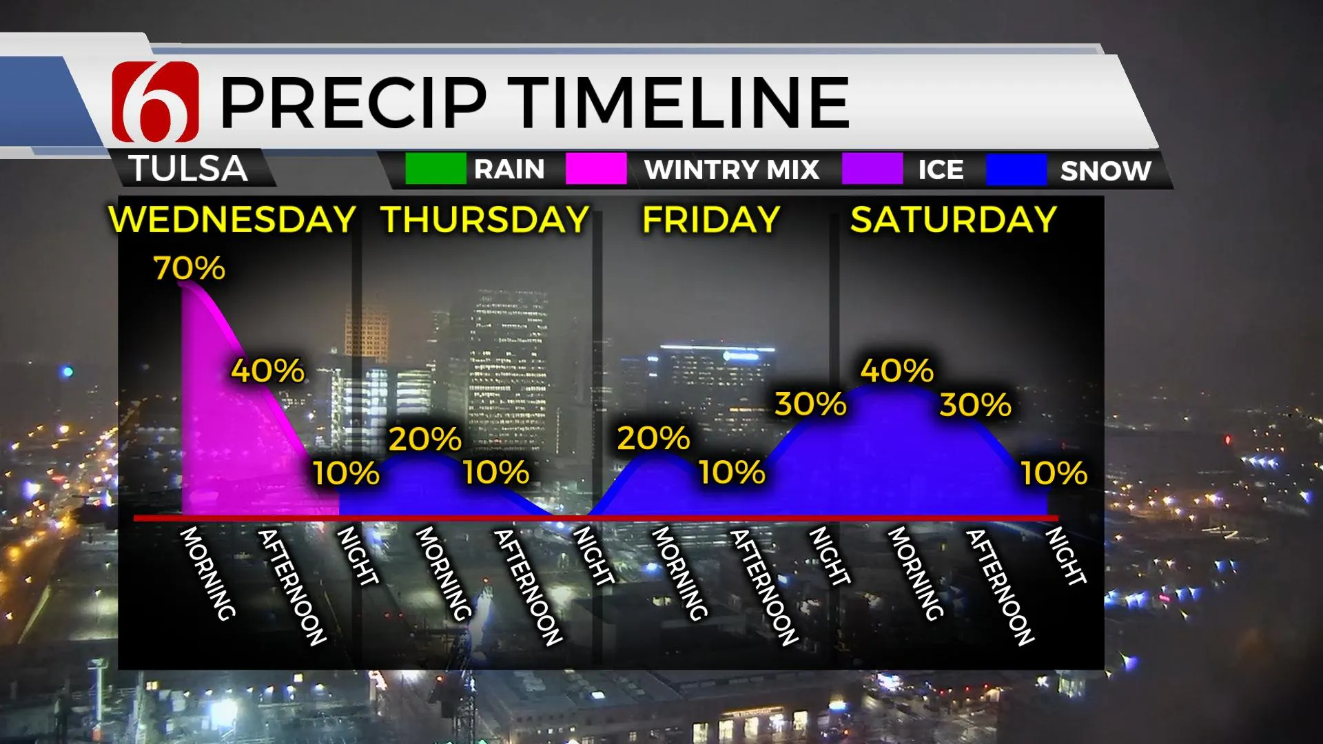
Another weak wave nears the region early Thursday with some light scattered wintry mix across southeastern OK and a few snow flurries north. This chance will remain low but not zero. I’ll also keep a mention for a few snow flurries Friday across northern OK as a second surge of arctic air moves across the state bringing bitterly cold air across the state this weekend with wind chill values dropping from zero to -20 in some locations. Temperatures this weekend will start with lows in the single digits and highs only in the teens near the metro. A disturbance is expected to near the state late Friday night into Saturday morning bringing some snow chances across southern Kansas into part of Oklahoma. Data is more consistent regarding run-to-run consistency within individual models but still depict differences regarding snowfall locations and amounts. Based on some of these data, I have a 40% chance of snow late Friday evening into Saturday. A second upper-level wave, possibly even stronger, will dive through the intermountain region Sunday night and eject across the southern plains, across part of Texas Monday while moving east Tuesday. This wave appears stronger than the first and I have increased the chances for snow for this wave to 50%.

Another major issue will be the bitterly cold weather reinforced by the second surge of arctic air arriving by the end of this week. This airmass will not change much and will continue the trend of sub-freezing temps started this past Monday across the state. This pattern of below freezing temps may continue through most of next week before slowly modifying Thursday or Friday. While some cold weather preparations have no doubt already occurred for many folks, additional preparations may be required due to the prolonged period of bitterly cold weather expected to persist across the region. This includes checking air pressure in tires, the fluid levels, and the heath of the battery in your vehicle. Some residents may need to open cabinets adjacent to water pipes and sinks while allowing faucets to drip. Water hoses should already be disconnected from outside water sources. Exposed spickets should be covered from the elements. And of course, please check on elderly residents, neighbors and family members who may need some assistance to accomplish these preparations. It is also a good idea to pack extra blankets and coats in vehicles in case of breakdowns or being stranded on roadways.

Thanks for reading the Wednesday morning weather discussion and blog.
Have a super great and safe day.
Alan Crone
KOTV
More Like This
February 10th, 2021
February 14th, 2022
January 26th, 2022
January 25th, 2022
Top Headlines
December 11th, 2024
December 11th, 2024
December 11th, 2024
December 11th, 2024


