

Winter Weather Advisories, Freezing Temperatures Continue For Green Country
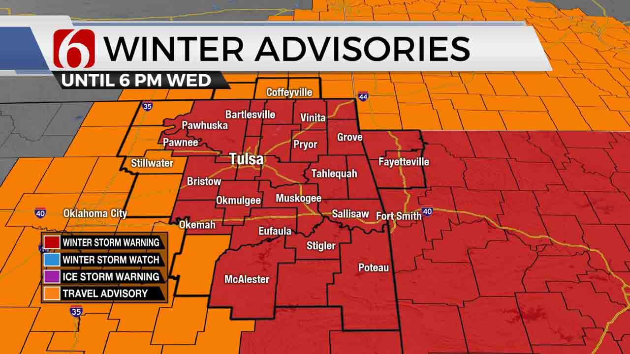
Light snow will continue moving across a broad area of northeastern OK this morning with occasional moderate snow bands as the winter storm warning will remain in effect through the day.Wednesday, February 17th 2021, 9:33 am
Light snow will continue moving across a broad area of northeastern OK this morning with occasional moderate snow bands as the winter storm warning will remain in effect through the day. We think this warning will be gradually scaled back later this afternoon as the snow will also become less of an issue for the northern sections, while continuing slightly longer to the southeast. Additional daytime accumulations of 1 to 3 inches will be possible in addition to snow that occurred overnight staying in line for our forecast accumulation for the entire event between 3 and 6 inches. Southeastern OK is currently in a lull and may remain so for most of the day even though I’ll keep additional chances along highway 270 eastward this afternoon and tonight. The latest data support the heavier snows slightly more southeast, across extreme southeastern OK and northeast Texas overnight.

Temperatures have finally leveled off and will remain in the lower to mid-teens this morning before attempting to reach the lower 20s this afternoon. The winds will gradually increase speeds from the northeast around 10 to 15 mph but will remain mostly light for the morning. As posted here yesterday, the upper air pattern has already changed when compared to last week and this means improvement is slowly on the way.

The mid to upper-level trough currently providing broadscale lift across the southern plains will not clear our immediate area until Thursday morning to midday. While the bulk of the snow will continue to ‘thin-out’ by midday to afternoon today, some very light snow or flurries will be possible into early Thursday morning before we finally rid this upper trough and begin to modify the arctic airmass at the surface. The new, fresh additional snow will enforce the snowpack effect on the ground, which will in turn keep temperatures colder than they would normally be as the trough pulls away from the area this weekend. But sunshine will return for most of the following days Thursday afternoon into Saturday, with a few clouds, especially Sunday as another fast-moving trough moves across the plains. This system will also bring a surface front through the state Sunday with the possibility of a few showers. The moisture profile is not exceptionally robust, but there may be enough for a few showers, liquid variety, before the front clears our area Sunday evening.
Monday into Tuesday will bring much needed relief with highs reaching the lower to 50s Monday and nearing 60 Tuesday. The upper flow will continue to be highly active for the foreseeable future, including the potential for several notable weather makers during the next two weeks.
Thanks for reading the Wednesday morning weather discussion and blog.
Have a super great day! Be Safe on the roadways.
Alan Crone

Get The Daily Update!
Be among the first to get breaking news, weather, and general news updates from News on 6 delivered right to your inbox!
More Like This
February 17th, 2021

August 8th, 2023

July 4th, 2023

May 8th, 2023
Top Headlines

December 12th, 2024

December 12th, 2024

December 12th, 2024
