

Early Morning Severe Weather Threats, Flood Watch Remains For Most Of Eastern Oklahoma
Alan Crone has the latest look at what you can expect from your Wednesday forecastWednesday, April 28th 2021, 6:29 am
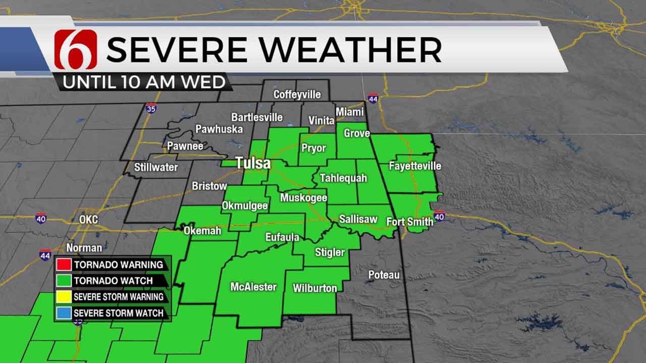
A tornado watch remains for the morning hours along and east-south of the I-44 corridor. This includes the Tulsa metro. A flood watch remains for most of the Eastern OK through the day.
A messy pattern remains for the next 24 to 36 hours, including the potential for pockets of heavy rainfall and some severe storms. A strong upper-level system currently to our west will continue moving east while opening as it drops southeast. A surface cold front positioned across Kansas today will move southeast later this afternoon and evening bringing additional storms to the region. The entire system exits far southeastern OK later tonight with improving weather Thursday through most of the weekend.
The current upper-level system may slow down as it enters Texas this weekend and could bring a few showers or storms across far southeastern OK Sunday afternoon or evening. Our probability in the metro remains very low Sunday. Another strong-looking upper-level system will be nearing the state early next week and should bring additional storm chances to the region. Highs today will stay in the lower 70s along with southeast winds from 10 to 25 mph. Temps drop into the upper-50s later tonight and stay only in the upper 60s and lower 70s Thursday with decreasing clouds and north winds near 15 to 25 mph. Gusty south winds are likely this weekend with highs reaching the upper 70s to lower 80s.
We’ve been tracking storms overnight and continue to do so through the morning hours. A few strong and severe storms will remain possible, even early this morning as stronger shear overspreads the region. Some strong to severe storms will remain possible due to the high moisture content and low condensation levels in the atmosphere. Our main threat for the next few hours will be heavy rainfall and a few storms producing some hail. But one or two cells could produce rotation and a tornado warning is not impossible. The tornado watch for the morning expires at 10 a.m., but additional watches would be possible later today and early evening.
Model consensus indicates rainfall from 1 to 2 inches will be possible along the highway 412 corridor, with amounts between 2 to 3 inches possible over a larger area of East-central OK. Extreme eastern OK into western Arkansas may experience total rainfall nearing 4 inches or slightly higher. Some localized flooding issues will be possible. And we’ll be monitoring the Illinois River basin for any increases during the next 48 to 60 hours as this system exits the region.
The cold front will move across northeastern OK later tonight and exit southeastern OK pre-dawn Thursday. This should take most of the precipitation out of the area during this period. The remainder of Thursday afternoon will support dry and improving weather, and this is expected to continue Friday into most of the weekend.
Thanks for reading the Wednesday morning weather discussion and blog.
Have a super great day! And remain aware of your weather surroundings.
Alan Crone
KOTV

Get The Daily Update!
Be among the first to get breaking news, weather, and general news updates from News on 6 delivered right to your inbox!
More Like This
April 28th, 2021

June 21st, 2023

June 19th, 2023

June 13th, 2023
Top Headlines

December 13th, 2024

December 13th, 2024

December 13th, 2024

December 13th, 2024