

Severe Weather Threats Move Back In To Northeast Oklahoma
Another storm system nears the state bringing severe weather chances to Northeast OklahomaMonday, May 3rd 2021, 9:12 am
A series of upper-level systems will be influencing the southern plains, including Oklahoma for the next two to three weeks before the main belt of westerlies begins migrating slightly northward. The first disturbance arrives later today and early tomorrow morning, a second Wednesday night into Thursday, and another nearing by this weekend. The pattern next week supports several disturbances nearing the state with the potential for a quasi-stationary boundary remaining in the area. Our first concern will be today, including the likelihood of more storms later tonight along with severe thunderstorm threats and heavy rainfall.

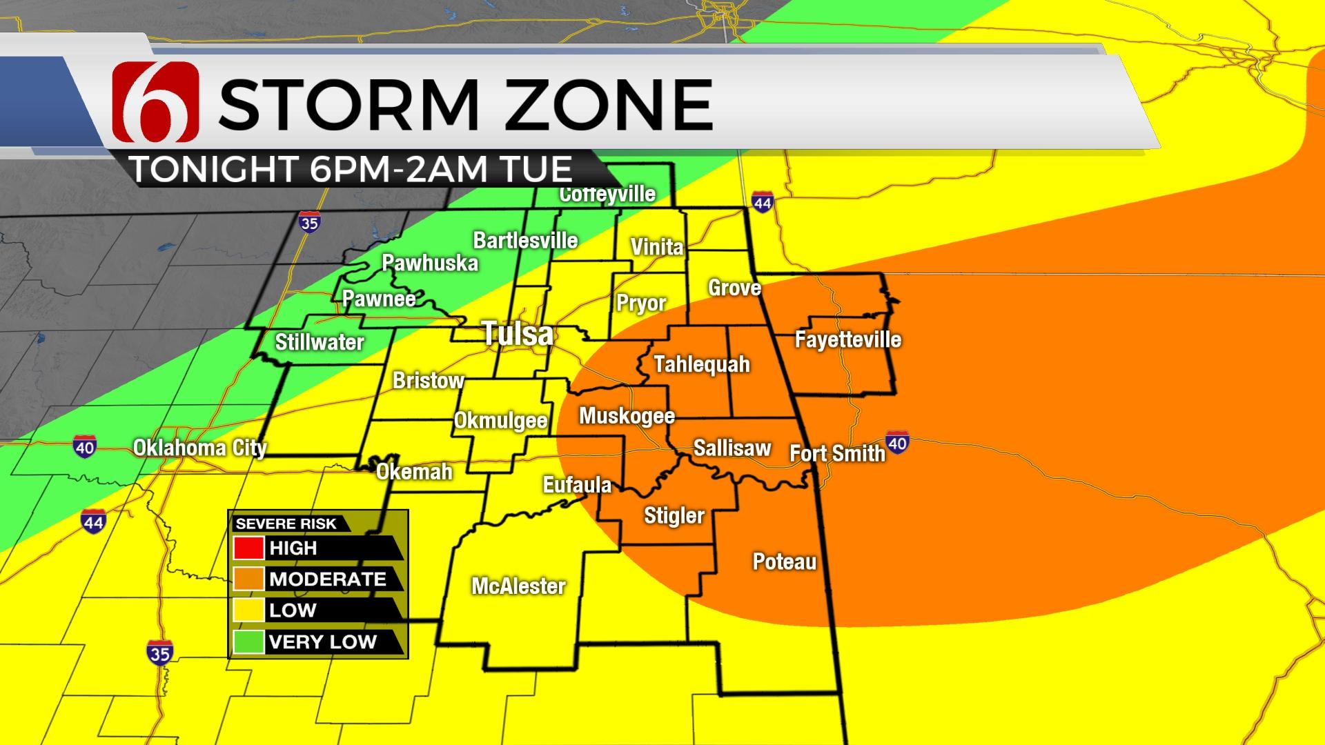
A decaying area of thunderstorms located across Kansas will attempt to move into northeastern OK early this morning. Most data support this activity weakening, but an outflow boundary is expected to survive the trip and become positioned near I-44 this morning through the afternoon before a cold front approaches the region later tonight. A layer of warm air aloft (the CAP) may suppress thunderstorm activity for most of the afternoon, but by early evening, storms will attempt to develop as colder air aloft arrives from the west and a meso-surface flow approaches from the southwest. Thunderstorms that do form ahead of these features could become surface-based by tonight with all modes of severe weather possibilities, especially southeast of the Tulsa metro. As the cold front moves across the state later tonight and pre-dawn Tuesday, some wrap-around showers will be likely across far northern OK and southern Kansas. The entire system will be exiting the area early Tuesday morning.

Temperatures today will climb into the upper 70s or lower to mid-80s with mostly southeast winds across the southern sections. Some locations of northeastern OK may experience east or northeast winds for the midday behind the above-mentioned outflow with locations north of this boundary staying in the 70s. As the surface low lifts northeast later tonight with thunderstorms, Tuesday morning lows will be in the mid-50s with cooler Tuesday afternoon highs in the lower to mid-60s with northeast winds from 15 to 30 mph. Wednesday morning starts with lows in the lower to mid-40s and highs reaching the lower 70s with mostly sunny conditions. Temperatures will remain in the lower to mid-70s for the rest of the period.

We should get a break for most of Wednesday, but another disturbance will near the state Wednesday evening bringing another small chance for a few storms into part of the area overnight into Thursday morning before quickly exiting the region. As posted above, the upper air pattern may become active again this weekend and continue for several days next week with additional thunderstorm chances. I’ll post more about this forecast period tomorrow.
Remain aware of your weather surroundings later tonight.
Thanks for reading the Monday morning weather discussion and blog.
Have a super great day!
Alan Crone
KOTV
If you’re into podcasts, check out my daily weather update below. Search for NewsOn6 and ‘Weather Out The Door’ on most podcast providers, including Apple, Stitcher, Tune-In and HERE on SoundCloud.

Get The Daily Update!
Be among the first to get breaking news, weather, and general news updates from News on 6 delivered right to your inbox!
More Like This

June 21st, 2023

June 19th, 2023

June 13th, 2023
Top Headlines

December 13th, 2024

December 13th, 2024

December 13th, 2024

December 13th, 2024