Another Storm System Nears The State
South winds return today with highs reaching the upper 70s to lower 80s as our next storm system nears the state.Tuesday, October 12th 2021, 6:51 am
TULSA, Oklahoma -
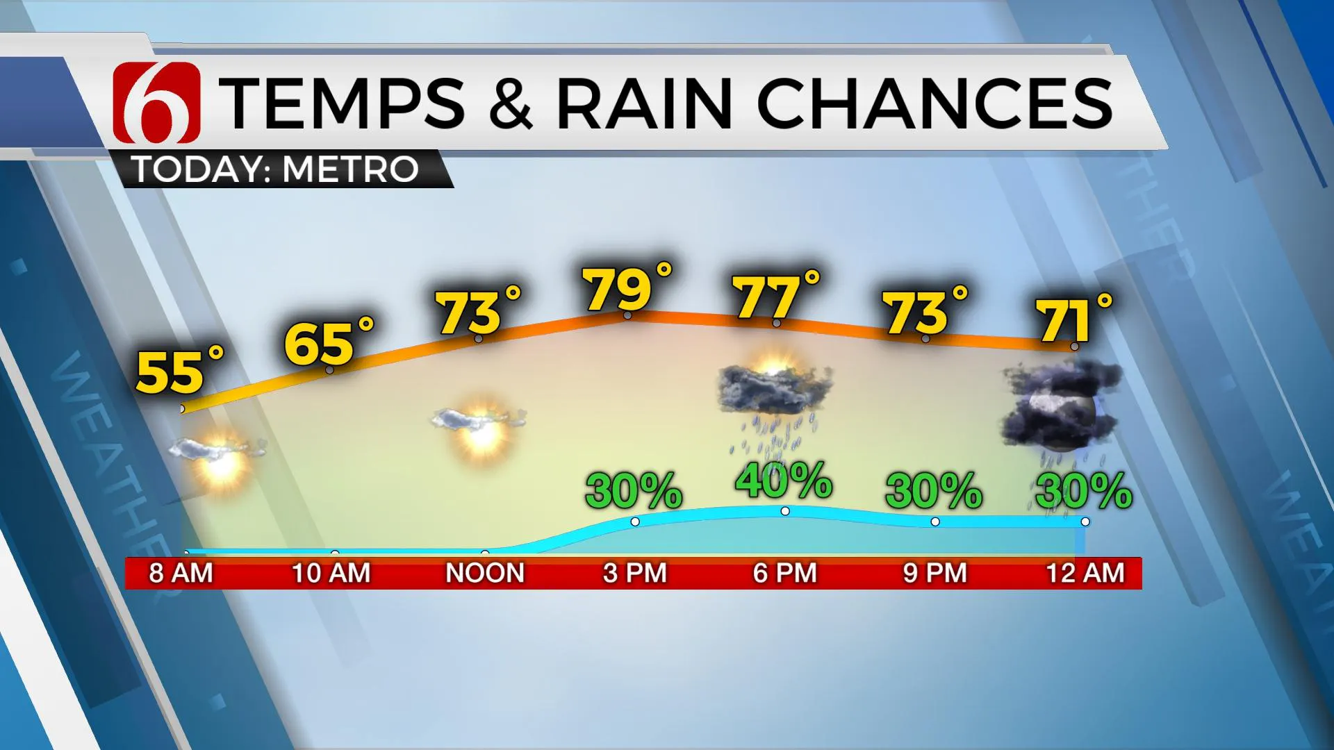
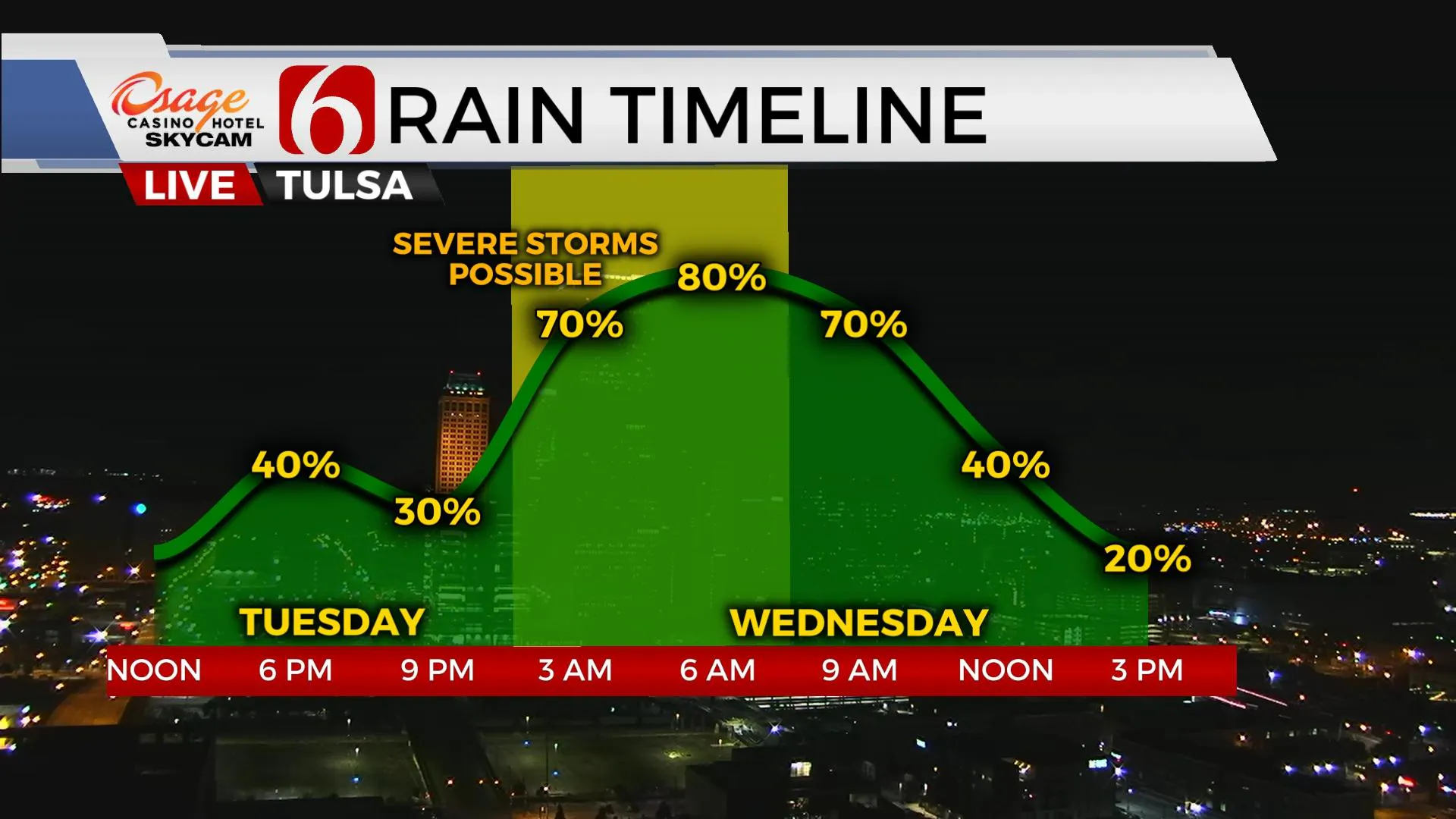
South winds return today with highs reaching the upper 70s to lower 80s as our next storm system nears the state. A few scattered storms will be possible throughout the day, but many locations will remain dry. Higher chances arrive late tonight through early Wednesday morning as a powerful storm system impacts the southern plains. Active weather remains through the end of the week with some additional storm chances before wonderful fall weather returns this weekend.

A powerful upper-level low located across the inter-mountain region will eject into the central plains Wednesday and be positioned near the Dakotas Wednesday evening and into southern Canada Thursday morning. A surface boundary will enter northwestern OK tonight and storms will become likely as strong winds aloft, nearing 70 to 90 knots, move around the base of the trough into western Kansas and eastern Colorado. The positioning of the stronger winds, surface boundary and returning moisture suggest higher threats for significant severe storms will remain more to our west this evening before storms approach I-35 around 3 a.m. Wednesday and entering northeastern OK shortly before dawn. This activity is expected to be strong to severe with damaging winds the primary threat near central OK. A few of the embedded cells may still be severe as they approach our western sections, near or northwest of I-44 early tomorrow morning before gradually weakening during the early morning hours as the main upper-level forcing ejects away from the state. The upper air flow will remain nearly parallel to the surface boundary Wednesday and Thursday as it stalls near the region. Another weaker disturbance is projected to move from north TX into southeastern OK Thursday with additional showers and storms near this boundary, including threats for locally heavy rainfall and possibly one or two severe storms. A tropical system in the Pacific is also expected to move into south Texas Thursday, and some moisture from this system could sneak up into far southern OK Thursday evening. Finally, another strong upper trough moves across the state early Friday bringing a strong surface cold front across the state. This could bring a few showers Friday morning, but the data is inconclusive. It is highly likely this front will bring gusty north winds and drier air across the area Friday afternoon with highs staying in the upper 60s or lower 70s along with north winds from 15 to 25 mph. The weekend pattern appears very pleasant and very autumnal with morning lows in the mid-40s and highs near 72 Saturday and mid-70s Sunday with abundant sunshine and pleasant north winds.

Thanks for reading the Tuesday morning weather discussion and blog.
Have a super great day!
Alan Crone
KOTV
If you’re into podcasts, check out my daily weather update below. Search for NewsOn6 and ‘Weather Out The Door’ on most podcast providers, including Apple, Stitcher, Tune-In and down below on Spotify.

More Like This
October 12th, 2021
February 14th, 2022
January 26th, 2022
January 25th, 2022
Top Headlines
December 11th, 2024
December 11th, 2024
December 11th, 2024
December 11th, 2024


